Testing Sep 2025
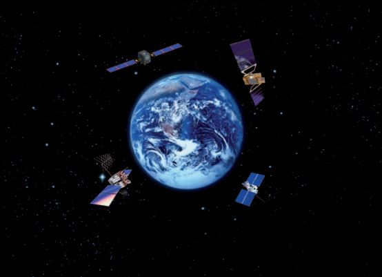
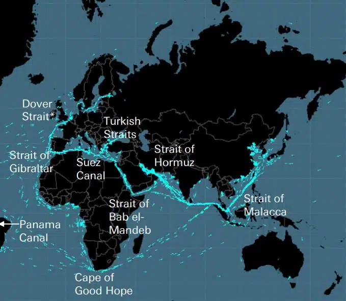
Kabler, rørledninger, veier, sjøsund, flyruter og satellitter danner det skjøre nettverket som den globale økonomien er bygget på. Dette er usynlige nettverk av enorm betydning for den globale forsyningskjeden og det moderne livet, som imidlertid bare huskes når en krig som den i Ukraina eller Israel truer en av disse strategiske […]
DEEPSEA: neste generasjons reiseoptimalisering drevet av Artificial Intelligence (AI) Bruk Artificial Intelligence (AI) Performance Routing for å øyeblikkelig akselerere flåtens avkarboniseringsbane og redusere drivstoffkostnadene. Ytelsesruting vil ha en stor, kvantifiserbar innvirkning på flåtens drivstofforbruk og CII i dag, resultater med høy effekt fra dag én. "DeepSea Vessel Voyage Optimization AI Solution reduserer utslipp, […]
World's most famous Luxurious Marinas: Which are the most luxurious and popular marinas worldwide? Portofino, Monaco, St. Tropez, Ibiza, St. Barts. One of the first images that comes to mind when we think of these places are their iconic marinas. Dignitaries, powerful people of wealth, glamorous Hollywood stars and all those who have made yachting […]
Fishing is changing for the good of the Earth - advanced bio-based plastic solutions (By Tassoula Eptakili - www.kathimerini.gr) Almost 12 million tons of plastic waste end up in the world's oceans every year. Sometimes they travel in the water, creating huge underwater garbage dumps, and sometimes they come ashore. The effects of mindless consumption […]
Google - Data Centers Through 2022, Google has strengthened its commitment in Greece to accelerate sustainable and inclusive development and digital transformation, further intensifying its substantial support to the country. With strategic initiatives, and with a focus on people, the technology company opened a new important chapter in Greece with the announcement of the creation […]
Lloyd's List's One Hundred People, rangering av innflytelse og makt innen skipsfart Individuelle handlinger er fortsatt viktige i skipsfart, selv om skipseiernes makt avtar. Likevel har årets avgjørende øyeblikk kommet fra EU, som har gått forbi IMO som den mest innflytelsesrike kraften i bransjen, ved å ta konkrete tiltak for å håndtere klimaendringer, IT […]
UKHO announced intention to end Paper Nautical Chart production (26 July 2022) (source: UK Hydrographic Office) The UK Hydrographic Office (UKHO) has announced on 26 July 2022 its intention to develop options for the withdrawal from global paper nautical chart production by late 2026 to increase focus on its digital navigation products and services. ("UKHO […]
Helt siden folk begynte å bygge kompliserte ting, innså de at det var behov for et målesystem. Opprinnelig var grunnlaget menneskekroppen. Det revolusjonerende Frankrike skulle produsere det som utviklet seg til det definitive International System of Units (International Measurement System) Egypterne brukte alen som var omtrent 52,4 centimeter, men fordi […]
Arcadia Shipmanagement's Aegean Myth ble anerkjent av DNV som det første verifiserte SEEMP III fartøysklassifiseringsselskapet DNV ga Arcadia Shipmanagement Co Ltd et sertifikat som anerkjenner deres fartøy Aegean Myth som det første skipet globalt som har en SEEMP III-manual. Ship Operational Carbon Intensity Plan eller SEEMP Part III, er en del av […]
Fra august 2022 vil de flygende delfinene fra Hellenic Seaways, som fraktet dusinvis, om ikke hundrevis av millioner av greske og utenlandske passasjerer i Argosaronicos-bukten de siste fem tiårene, gå ned i historien. Assosiert med oppfatningen av de fleste som støyende, men raske kjøretøy for sommeren og ikke bare rømming, hovedsakelig i Argosaronicos, […]
(Marine Shipping Glossary terms are offered by Hellenic Shipping News) press CTRL + F in your web browser to pop up the Search Bar and type the term you want to find... Maritime Dictionary app in Google Play Maritime Dictionary App Marine (app) in google Play Shipping Dictionary (app) in Google Play Naval Terms Dictionary […]
Kartrettelser og oppdateringer Gamle, ikke oppdaterte (siden enda noen få uker) sjøkart skal aldri brukes til maritim navigasjon og reiseplanlegging. Spesielt egenskapene til en elv som er fremstilt på et sjøkart har en tendens til å endre seg kontinuerlig, og kunstige navigasjonshjelpemidler til sjøs eller på kysten kan endres når som helst. Som en […]
NOAA's Nautical Paper Charts (Raster Nautical Charts: both paper and digital Raster Charts) will soon not be produced any more (by 2025) On April 13, the US federal government's National Oceanic & Atmospheric Administration (NOAA) announced it will soon stop printing traditional lithographic (paper) nautical charts - while other forms of nautical charts, such as […]
Nettkarttjenester (sammenligning) Mest populære nettkarttjenester Google Maps Bing Maps MapQuest OpenStreetMap Her WeGo Apple Maps Yandex Maps Sammenligningsliste Funksjon Google Maps Bing Maps MapQuest OpenStreetMap Her WeGo Apple Maps Yandex Maps Lisens Proprietært Proprietært Proprietært ODbL Proprietært ekstra proprietært Tilgjengelighet proprietært Australia, Canada, Kina, Frankrike, Tyskland, Israel, Italia, […]
A catalog of free (not necessarily Open Source) Satellite Navigation (or "GPS") software for a wide range of devices. (Navigation software with free maps - often uses maps from OpenStreetMap project) Satellite Navigation Software- Non-free maps Name Company Type of device[5] Operating system 3rd-party GPS-able?[6] Software with maps? Follows streets? Open-source? Remarks Aqua Map[29] GEC […]
hva er forkortelsene som brukes i sjøkart (admiralitetskart / sjøkart) Bunnkarakteristikk og forkortelser Substantiv Kildekart Substantiv Forkortelse Forkortelse Boulders Blds Blds Clay Cl Cy Coral Co Co Coralhead Cl Hd Cl Hd Grus GG Grass Grs Grs Mud […]
Filipinos: major source of Seafarers for the global maritime sector - One third of the world's seafarers are Filipinos. In the 1970s, the number of seafarers in traditional maritime countries dropped, resulting in a transfer of supply to countries such as India, China, and the Philippines. The Philippines has developed to become a significant producer […]
En sofistikert ny portal for sjøkart og publikasjoner er lansert som ikke har noe abonnement eller minimumskontraktstid, og gratis oppdateringer og rettelser. OpenC247.com svarer på den økende etterspørselen etter digitale teknologier i den maritime sektoren. Den myke lanseringen av portalen har tiltrukket seg mer enn 150 registrerte brukere, fra kapteiner på super […]
European Digital Twin of the Ocean (European DTO) This tool will model the ocean and provide knowledge and understanding of the past and present and will create credible predictions of the ocean's future health. The ILIAD consortium will develop virtual representations of the sea that will integrate earth observing, modelling and digital infrastructures to provide […]
What is the Differences between VECTOR and RASTER Graphics? (right below its treated the difference Raster/Vector in regards to graphics - look further below for the difference between Vector Nautical Charts (VNC) and Raster Nautical Charts (RNC)) There is some confusion to many people when it comes to the differences between vector and raster graphics. […]
(* source: www.sailingissues.com - by Diederik Willemsen) Marine Navigation courses (FREE) Find advanced online course on marine navigation for offshore sailing. All though nowadays most sailors rely on maritime navigation and positioning equipment like the use of GPS / Galileo / GLONASS and Radars to navigate, by navigating by yourself is a lot more fun, Learn navigation to sail […]
(* source: NOAA - the National Oceanic and Atmospheric Administration (USA), the American scientific and regulatory agency - Symbols, Abbreviations and Terms used on Paper and Electronic Nautical Charts ENCs) Paper and Electronic Navigational Charts: Symbols, Abbreviations and Terms used on Marine Navigation Charts see a full list of symbols used on paper nautical charts […]
GLOSSARY of Nautical Charts, terms & abbreviations used in the maritime industry (* source: NOAA - the National Oceanic and Atmospheric Administration (USA), the American scientific and regulatory agency) An authoritative source for terms used in cartography (mapping), marine charting, and geodesy used in the nautical charting program. Terms and definitions are of specific cartographic […]
Finn alle toppleverandører av marinenavigasjonsprodukter og -tjenester for sikker maritim reiseplanlegging