Navionics (Garmin) cartography – (Marine Charts) integrated offshore and inland marine mapping
NAVIONICS CARTOGRAPHY (Garmin), Marine Charts
Navionics cartography provides integrated offshore and inland marine mapping content with rivers, bays and more than 42.000 lakes around the world. This all-in-one solution offers clear, reliable cartography for the widest range of chartplotter brands.
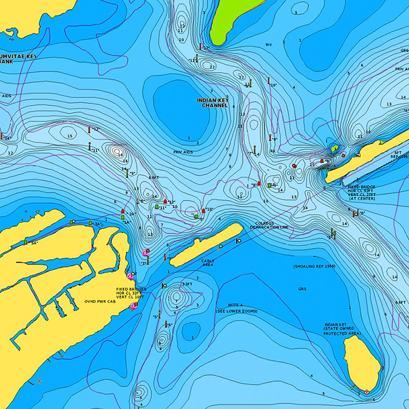
Nautical Charts – comprehensive charts are derived from multiple official, government and private cartography sources, displayed in a familiar look and feel.
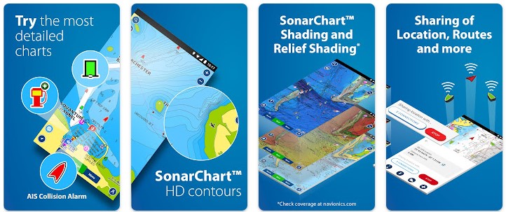
SonarChart HD Bathymetry – innovative 1' (0,5 m) bathymetry charts are created by using Navionics proprietary systems that augment existing content with sonar data contributed by the boating community.
Community Edits – you get useful local knowledge from edits made by users of the Navionics Boating app on your compatible smart device.
Daily Updates – up to 5.000 daily updates to charts provide the most accurate, most current data available. Navionics constantly enhances its nautical charts with new and amended content from official hydrographic sources, public and private surveys, and millions of contributions from boaters, as a result they make up to 5.000 updates every day affecting all Navionics marine chart layers.
Marine Charts suitable for cruising, fishing, sailing, boating.
Navionics Plus Nautical Charts - Regions North Lake Charts SD-MSD
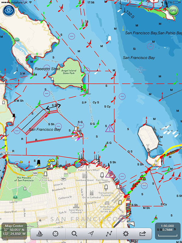
Nautical Charts - Navionics Boating charts
Nautical Charts - COVERAGE AREAS
Worldwide map coverage is available, with integrated content making it easier to select the navigation features and map regions you want. Choose from large coverage areas (Large) to more localized chart cuts (Regular).
Established in 1984, in Viareggio, Italy, Navionics® produces electronic charts for the leisure boating market
Since Garmin® and Navionics came together in 2017, they have been comparing and combining the best of their data and technology to produce superior cartography products
Marine Charts application in google play store - Boating Marine & Lakes app by Navionics
A great Navionics app for cruising, fishing, sailing, diving and all your marine and lake activities. Offers the same detailed marine and lake nautical charts and advanced features as on the best GPS plotters, and more.
TRY FOR FREE: Download the Navionics Boating Marine & Lakes app and try all charts and features for a limited time.
Navionics Marine Charts - Boating marine charts and lakes application
Navionics Marine Charts - Boating marine charts and lakes application
| Navionics: electronic navigation charts of marine areas, lakes, rivers
|
Navionics (Garmin) nautical cartography (Marine Charts) offers integrated offshore and inland marine mapping.
Garmin Navionics+ and Navionics Vision+™ Marine Cartography |
Navionics is an Italian manufacturer of electronic navigational charts, headquartered in Massarosa, Italy. The company operates worldwide with subsidiaries in Wareham, Massachusetts, Plymouth (United Kingdom), Hyderabad (India) and New South Wales (Australia).
Navionics was founded in 1984, when Giuseppe Carnevali and Fosco Bianchetti introduced the world's first marine electronic chart plotter, the Geonav. In 2007, Navionics sold the Geonav product line, to focus solely on the production of electronic nautical charts.
On October 27, 2017, Navionics was acquired by Garmin Ltd.
(source: wikipedia)
Tag
Video
Location
Contact Information
-
March 20, 2022

-
February 14, 2022

-
February 14, 2022
-
February 14, 2022