(* ソース: NOAA – 米国海洋大気庁 (USA)、アメリカの科学および規制当局– 紙および電子海図ENCで使用される記号、略語、および用語)
紙で使用されている記号の完全なリストを参照してください 海図 (およびそれらのデジタルラスターイメージに相当するもの)および描写に使用される対応する記号 電子海図 (ENC)データ 電子海図情報表示装置 (ECDIS)。
https://www.nauticalcharts.noaa.gov/publications/docs/us-chart-1/ChartNo1.pdf
例:
2019年4月15日
米国で共同で作成
商務省–米国海洋大気庁
国防総省–国家地理空間情報局
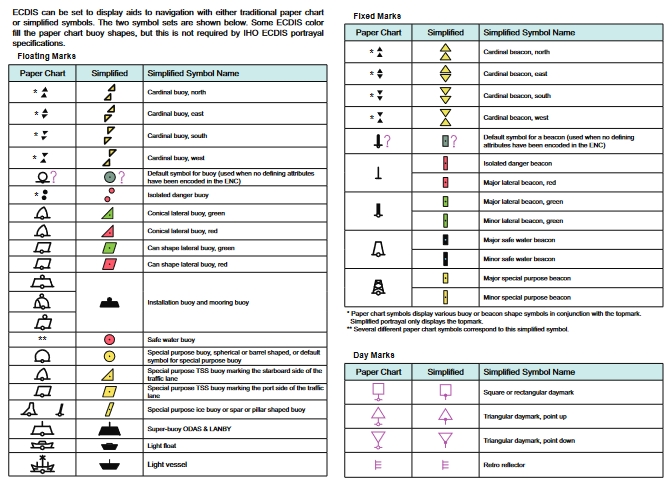
電子海図情報表示装置(ECDIS)で電子海図(ENC)を表示するための記号体系が、米国の海図1に追加されました。
米国海図1の従来の文字セクションに示されているECDIS記号に加えて、ECDISに関する重要な詳細を提供することに専念するいくつかの特別なページがあります。これらのページは、このページの左上隅に示されているように、ECDISアイコンで区別されます。 ECDISページは、目次にイタリック体でリストされています。
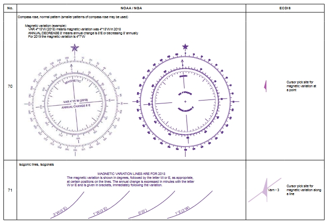
紙海図とENCの使用における大きな違いの1つは、ユーザー設定や船のドラフトなどの他の条件に応じて、ECDISが同じ機能を異なる方法で表示できることです。重要な例は、ECDISが残骸、岩、その他の障害物を、船に設定された安全輪郭の深さ以上の場合、従来の「紙海図」記号で表示することです。浅瀬である危険は、左に示されているユニークなECDIS「孤立した危険」記号で描かれています。 (ECDISの安全輪郭の詳細については、ECDISの深さの描写のページを参照してください。)
ECDISが紙のチャートよりも優れているもう1つの利点は、ユーザーが「カーソルピック」を介して機能に関するより多くの情報を取得できることです。カーソルピックによって取得できるいくつかの機能属性値は、米国のチャートNo. 1全体に記載されています。これは、高さ、垂直方向のクリアランスなどの特定の値がINTシンボルの説明に含まれている場合に特に当てはまります。左に示されているカーソルピックアイコンは、カーソルピックへの参照がいつ行われたかを示すために使用されます。
特に記載されていない、カーソルピックを介してユーザーが取得できる属性値は他にもたくさんあります。これらには、目的、季節性、周期性、ステータス、色、高さ、構造のタイプ、および特徴の視覚的またはレーダーの目立ちやすさが含まれますが、これらに限定されません。ブイの形状、色、または色のパターン。ライトの特性;障害物と難破船のカテゴリ。レーダー波長、無線周波数、通信チャネル、コールサイン。 AIS送信信号の存在;水先案内サービスなどに関する情報。
US Chart No. 1は、 ECDIS ユーザーですが、義務付けられたECDISトレーニングに代わるものではありません。
ECDISのユーザーと開発者のコミュニティは、米国海図1のECDISシンボルと情報の表示を改善するために招待されています。次の版で見たい追加情報をNOAAに知らせてください。
米国海図第1号に関する訂正、コメント、または質問は、ASSIST、NOAA沿岸測量部の利害関係者の関与およびフィードバックのWebサイトを通じて提出できます。 www.nauticalcharts.noaa.gov/customerservice/assist,
または郵送先:
国立海洋局、NOAA(N / CS2)注意:米国チャートNo. 1
1315 East West Highway Silver Spring、MD 20912-3282
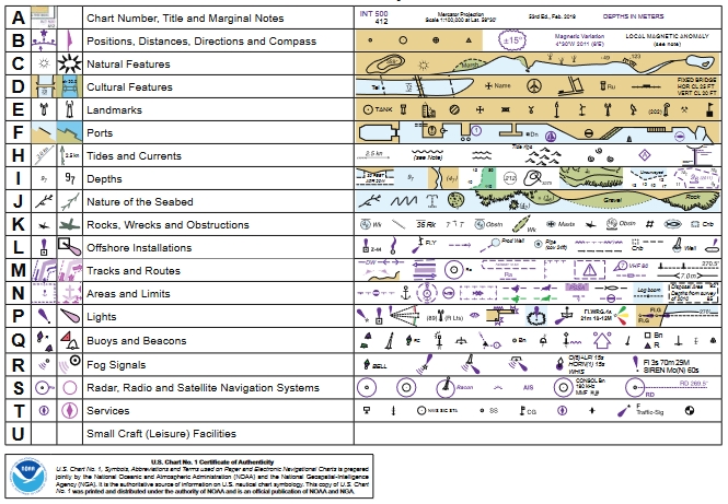
シンボル、 略語と用語
セクションの文書化と ECDISページ
はじめに5
概略レイアウト8
昼、夕暮れ、夜のカラーパレット9
目立つ特徴と目立たない特徴28
ECDISの深さの描写47
ECDIS69のルーティング手段の例
簡略化された従来の紙海図記号90
略語の索引111
インデックス117
付録1、IALA海事浮揚システム128
シンボルセクション
全般的
地形
水路学
ナビゲーション AIDS と サービス
完全なドキュメントを表示–紙および電子海図ENCで使用される記号、略語、および用語)
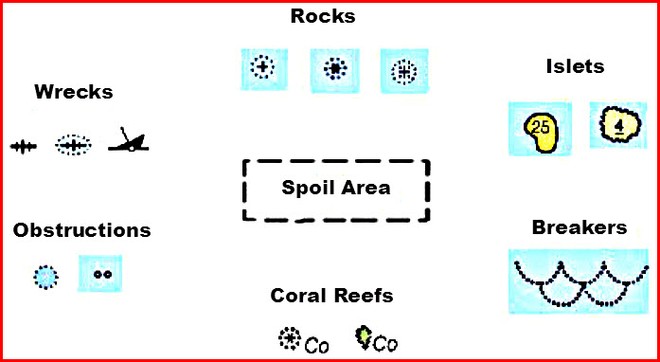
海図の7つの重大な危険シンボルを短時間で特定します。これらは、ボートの船体に穴を開けたり、キールを損傷したり、プロペラシャフトを曲げたり、プロペラを壊したり、座礁したりする可能性があります。.
今日、海図で使用されている危険記号は数十ありますが、ここではより一般的な記号をいくつか紹介します。これらの「船の殺人者」を知って、航海やクルーズを選択した場所ならどこでも、世界の海でより安全に滞在できます。
1.ロックス
塩基性岩の記号がプラス記号のように見えることに注意してください。これは、常に水面下にある岩を意味します。アスタリスクのような記号は、干潮時に岩が露出する(見えるようになる)ことを意味します。隅に点があるプラス記号は、干潮時でも岩が表面のすぐ下にあることを意味します。
2.小島(小さな島)
「小島」と呼ばれる小さな島々は、バハマ、カリブ海、太平洋でよく見られます。実線で囲まれた小島は、すべての潮汐段階で表示されます。数字は満潮時の最大高さ(またはチャートデータム)を示します。波状の波状の線で囲まれた小島は、潮で覆われ、覆われていません。満潮時には、小島が覆われます。数字は、潮汐の低い段階で覆われていないときの水面からの高さを示しています。
3.ブレーカー
ブレーカーは、海のうねりが海底と出会うときに形成されます。海底の高さはわずか1〜2倍です。たとえば、2フィートのうねりが2〜4フィートの深さの底を移動する場合、それは壊れます。
ブレーカーは、舵やプロペラの制御を失う可能性があるため、小さな船には危険です。
上の図に示されているような記号は避けてください。また、記号なしで単独で使用される略語「Br」が表示される場合があります。
4.サンゴ礁
世界で最も人気のあるクルージング場(バハマ、カリブ海の島々、太平洋の環礁)にも、最も危険な海域がいくつかあります。海図を注意深く調べ、岩や小島のシンボルの近くにある「Co」の略語を探します。
5.障害物
航海または電子海図表示では見逃しがちですが、障害物はプロペラ、シャフト、キールに損傷を与える可能性があります。多くの海図では、船員に警告するために略語「Obstn」のみを使用しています。円の周りの点は、未知の危険が表面の下に潜んでいることを意味します。小さな囲まれた円は、壊れた切り株、古い杭の残骸、または水没したポールとポストである可能性があります。
6.難破船
魚の骨と沈んだ船体のイラストは、最も一般的な難破船のシンボルを構成しています。点のない魚の骨は安全に渡ることができます。地図製作者はこれらを海図に載せて、商業用トロール漁船に網を引きずらないように警告し、船が停泊しないように警告します。船体の損傷を避けるために、点または沈んだ船体のシンボルで囲まれた魚の骨に広いバースを与えます。
7.スポイルエリア
疫病よりも致命的であり、「スポイルエリア」、「フィッシュヘブン」、「フィッシュトラップ」、「ダンピンググラウンド」などの説明を含む破線の輪郭を特定し、強調表示して、近づかないようにします。古い車やトラック、建築資材、ゴミがどこに行くのか疑問に思ったことはありませんか?今、あなたは知っています!深さが常に変化するため、スポイルエリアに音が表示されることはありません。
知っておく必要のある危険な略語
上記の記号の有無にかかわらず使用される危険な略語をよく理解してください。一目でわかるまでこれらを調べてください。
Rk、RまたはRks –ロックまたはロック
HkまたはWk–ハルクまたはレック
Obstn –水中障害物
Co –コーラル
ファウル–ファウルグラウンド
これらの追加の略語は、ハザードシンボルと一緒に表示される場合もあれば、単独で表示される場合もあります。たとえば、「Shoal Rep」は、船員によってその位置で浅瀬が報告された(「Rep」)ことを意味しますが、調査されていません。これらの略語でマークされたナビゲーションチャート上の領域には近づかないでください。
PA –おおよその位置
PD –疑わしい位置
ED –存在が疑わしい
担当者–報告
SD –疑わしいですね
これで、世界中の海図にある7つの危険グループのシンボルのいずれかを識別する方法がわかりました。これらのチャートナビゲーションの秘密を使用して、あなたに優位性を与え、あなたがクルーズすることを選択した場所であなたの乗組員を安全で健全に保ちます。
海図の記号と略語の詳細をご覧ください。無料の出版物「海図1:海図の記号、略語、用語」をダウンロードしてください。 ここ.
25年以上の経験を持つジョンジャミソン(キャプテンジョン)は、世界中でより安全な航海に必要な実用的なクルージングスキルを示しています。彼のウェブサイトwww.skippertips.comにアクセスしてください。無料で人気の高い毎週の「キャプテンジョンのセーリングのヒント」にサインアップしてください。何百ものセーリング記事、ビデオ、および電子書籍に即座にアクセスする方法を発見してください!
(出典:https://www.sail-world.com/Australia/Know-these-seven-danger-nautical-chart-symbols/-107197?source = google)
海図の読み方:海図に表示される記号、略語、およびデータの完全なガイド
NAUTICAL CHART SYMBOLS&ABBREVIATIONSアプリ iTunesアプリ
NAUTICAL CHART SYMBOLS&ABBREVIATIONSアプリ (Google Playストア)
スポンサー付きリスティング

安全な海上航海計画のためのマリンナビゲーション製品およびサービスのすべてのトッププロバイダーを検索する


