Testing Sep 2025
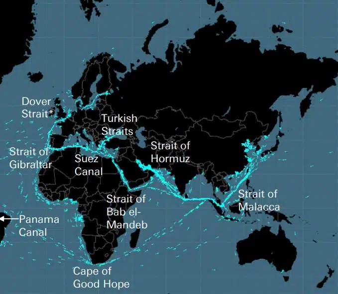
Kabel, jaringan pipa, jalan raya, selat laut, jalur udara dan satelit membentuk jaringan rapuh yang menjadi landasan perekonomian global. Ini adalah jaringan tak terlihat yang sangat penting bagi rantai pasokan global dan kehidupan modern, namun hanya diingat ketika perang seperti yang terjadi di Ukraina atau Israel mengancam salah satu negara strategis ini.
DEEPSEA: optimalisasi pelayaran generasi mendatang yang didukung oleh Kecerdasan Buatan (AI) Gunakan Perutean Kinerja Kecerdasan Buatan (AI) untuk secara instan mempercepat lintasan dekarbonisasi armada Anda, dan mengurangi biaya bahan bakar. Perutean Performa akan memberikan dampak besar yang dapat diukur pada konsumsi bahan bakar dan CII armada Anda hari ini, hasil berdampak tinggi sejak hari pertama. “Solusi AI DeepSea Vessel Optimisation AI mengurangi emisi, […]
World's most famous Luxurious Marinas: Which are the most luxurious and popular marinas worldwide? Portofino, Monaco, St. Tropez, Ibiza, St. Barts. One of the first images that comes to mind when we think of these places are their iconic marinas. Dignitaries, powerful people of wealth, glamorous Hollywood stars and all those who have made yachting […]
Fishing is changing for the good of the Earth - advanced bio-based plastic solutions (By Tassoula Eptakili - www.kathimerini.gr) Almost 12 million tons of plastic waste end up in the world's oceans every year. Sometimes they travel in the water, creating huge underwater garbage dumps, and sometimes they come ashore. The effects of mindless consumption […]
Google - Data Centers Through 2022, Google has strengthened its commitment in Greece to accelerate sustainable and inclusive development and digital transformation, further intensifying its substantial support to the country. With strategic initiatives, and with a focus on people, the technology company opened a new important chapter in Greece with the announcement of the creation […]
Seratus Orang Daftar Lloyd, pengaruh peringkat dan kekuatan dalam pengiriman Tindakan individu masih penting dalam pengiriman, bahkan saat kekuatan pemilik kapal memudar. Namun momen menentukan tahun ini datang dari UE, yang telah mengambil alih IMO sebagai kekuatan paling berpengaruh di industri ini, dengan mengambil tindakan nyata untuk mengatasi perubahan iklim IT […]
UKHO announced intention to end Paper Nautical Chart production (26 July 2022) (source: UK Hydrographic Office) The UK Hydrographic Office (UKHO) has announced on 26 July 2022 its intention to develop options for the withdrawal from global paper nautical chart production by late 2026 to increase focus on its digital navigation products and services. ("UKHO […]
Sejak orang mulai membangun hal-hal yang rumit, mereka menyadari bahwa ada kebutuhan akan sistem pengukuran. Awalnya dasarnya adalah tubuh manusia. Revolusi Prancis adalah untuk menghasilkan apa yang berkembang menjadi Sistem Satuan Internasional definitif (Sistem Pengukuran Internasional) Orang Mesir menggunakan hasta yang berukuran sekitar 52,4 sentimeter , tetapi karena […]
Mitos Aegean Arcadia Shipmanagement diakui oleh DNV sebagai masyarakat Klasifikasi kapal SEEMP III pertama yang terverifikasi. Rencana Intensitas Karbon Operasional Kapal atau SEEMP Bagian III, merupakan bagian dari […]
Mulai Agustus 2022, lumba-lumba terbang di Hellenic Seaways, yang membawa lusinan, bahkan ratusan juta penumpang Yunani dan asing di teluk Argosaronicos selama lima dekade terakhir, akan tercatat dalam sejarah. Terkait dengan persepsi sebagian besar kendaraan berisik tapi cepat untuk musim panas dan tidak hanya lolos, terutama di Argosaronicos, […]
(Marine Shipping Glossary terms are offered by Hellenic Shipping News) press CTRL + F in your web browser to pop up the Search Bar and type the term you want to find... Maritime Dictionary app in Google Play Maritime Dictionary App Marine (app) in google Play Shipping Dictionary (app) in Google Play Naval Terms Dictionary […]
Koreksi & Pembaruan Bagan Lama, tidak diperbarui (bahkan sejak beberapa minggu) Peta Laut tidak boleh digunakan untuk navigasi maritim dan perencanaan pelayaran. Karakteristik sungai, khususnya, yang digambarkan pada peta laut cenderung berubah terus menerus, dan alat bantu navigasi buatan di laut atau pantai dapat berubah setiap saat. Sebagai […]
NOAA's Nautical Paper Charts (Raster Nautical Charts: both paper and digital Raster Charts) will soon not be produced any more (by 2025) On April 13, the US federal government's National Oceanic & Atmospheric Administration (NOAA) announced it will soon stop printing traditional lithographic (paper) nautical charts - while other forms of nautical charts, such as […]
Layanan Peta Web (perbandingan) Layanan Peta Web terpopuler Google Maps Bing Maps MapQuest OpenStreetMap Di Sini WeGo Apple Maps Yandex Maps Daftar perbandingan Fitur Google Maps Bing Maps MapQuest OpenStreetMap Di Sini WeGo Apple Maps Yandex Maps Lisensi Proprietary Proprietary Proprietary ODbL Proprietary Proprietary Proprietary Ketersediaan Fungsi ekstra penuh Australia, Kanada, Cina, Prancis, Jerman, Israel, Italia, […]
A catalog of free (not necessarily Open Source) Satellite Navigation (or "GPS") software for a wide range of devices. (Navigation software with free maps - often uses maps from OpenStreetMap project) Satellite Navigation Software- Non-free maps Name Company Type of device[5] Operating system 3rd-party GPS-able?[6] Software with maps? Follows streets? Open-source? Remarks Aqua Map[29] GEC […]
apa singkatan yang digunakan dalam Nautical Charts (Admiralty Charts / Maritime Charts) Bawah Karakteristik dan Singkatan Kata Benda Source Chart Kata Benda Singkatan Singkatan Boulders Blds Blds Clay Cl Cy Coral Co Co Coralhead Cl Hd Cl Hd Gravel GG Grass Grs Grs Mud MM […]
Filipinos: major source of Seafarers for the global maritime sector - One third of the world's seafarers are Filipinos. In the 1970s, the number of seafarers in traditional maritime countries dropped, resulting in a transfer of supply to countries such as India, China, and the Philippines. The Philippines has developed to become a significant producer […]
Portal baru yang canggih untuk grafik dan publikasi bahari telah diluncurkan yang tidak memiliki langganan atau jangka waktu kontrak minimum, dan pembaruan dan koreksi gratis. OpenC247.com merespons meningkatnya permintaan akan teknologi digital di sektor maritim. Peluncuran lunak portal telah menarik lebih dari 150 pengguna terdaftar, dari kapten super […]
European Digital Twin of the Ocean (European DTO) This tool will model the ocean and provide knowledge and understanding of the past and present and will create credible predictions of the ocean's future health. The ILIAD consortium will develop virtual representations of the sea that will integrate earth observing, modelling and digital infrastructures to provide […]
What is the Differences between VECTOR and RASTER Graphics? (right below its treated the difference Raster/Vector in regards to graphics - look further below for the difference between Vector Nautical Charts (VNC) and Raster Nautical Charts (RNC)) There is some confusion to many people when it comes to the differences between vector and raster graphics. […]
(* source: www.sailingissues.com - by Diederik Willemsen) Marine Navigation courses (FREE) Find advanced online course on marine navigation for offshore sailing. All though nowadays most sailors rely on maritime navigation and positioning equipment like the use of GPS / Galileo / GLONASS and Radars to navigate, by navigating by yourself is a lot more fun, Learn navigation to sail […]
(* source: NOAA - the National Oceanic and Atmospheric Administration (USA), the American scientific and regulatory agency - Symbols, Abbreviations and Terms used on Paper and Electronic Nautical Charts ENCs) Paper and Electronic Navigational Charts: Symbols, Abbreviations and Terms used on Marine Navigation Charts see a full list of symbols used on paper nautical charts […]
GLOSSARY of Nautical Charts, terms & abbreviations used in the maritime industry (* source: NOAA - the National Oceanic and Atmospheric Administration (USA), the American scientific and regulatory agency) An authoritative source for terms used in cartography (mapping), marine charting, and geodesy used in the nautical charting program. Terms and definitions are of specific cartographic […]
Temukan semua penyedia produk & layanan Navigasi Laut teratas untuk Perencanaan Pelayaran Maritim yang aman