Testing Sep 2025
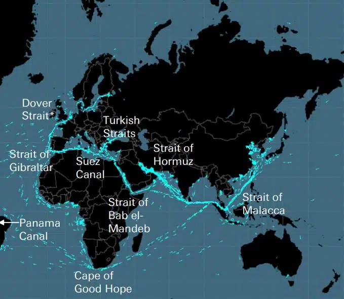
Kabels, pijpleidingen, wegen, zeestraten, luchtroutes en satellieten vormen het kwetsbare netwerk waarop de wereldeconomie is gebouwd. Dit zijn onzichtbare netwerken van enorm belang voor de mondiale toeleveringsketen en het moderne leven, die echter alleen in herinnering worden gebracht wanneer een oorlog zoals die in Oekraïne of Israël een van deze strategische gebieden bedreigt.
DEEPSEA: reisoptimalisatie van de volgende generatie mogelijk gemaakt door kunstmatige intelligentie (AI) Gebruik kunstmatige intelligentie (AI) Performance Routing om het koolstofarme traject van uw vloot onmiddellijk te versnellen en de brandstofkosten te verlagen. Performance Routing zal vandaag een grote, meetbare impact hebben op het brandstofverbruik en de CII van uw wagenpark, met grote impact vanaf de eerste dag. “DeepSea Vessel Voyage Optimization AI-oplossing vermindert de uitstoot, […]
World's most famous Luxurious Marinas: Which are the most luxurious and popular marinas worldwide? Portofino, Monaco, St. Tropez, Ibiza, St. Barts. One of the first images that comes to mind when we think of these places are their iconic marinas. Dignitaries, powerful people of wealth, glamorous Hollywood stars and all those who have made yachting […]
Fishing is changing for the good of the Earth - advanced bio-based plastic solutions (By Tassoula Eptakili - www.kathimerini.gr) Almost 12 million tons of plastic waste end up in the world's oceans every year. Sometimes they travel in the water, creating huge underwater garbage dumps, and sometimes they come ashore. The effects of mindless consumption […]
Google - Data Centers Through 2022, Google has strengthened its commitment in Greece to accelerate sustainable and inclusive development and digital transformation, further intensifying its substantial support to the country. With strategic initiatives, and with a focus on people, the technology company opened a new important chapter in Greece with the announcement of the creation […]
Lloyd's List's One Hundred People, rangschikking van invloed en macht binnen de scheepvaart Individuele acties zijn nog steeds van belang in de scheepvaart, ook al neemt de macht van reders af. Maar het beslissende moment van dit jaar kwam van de EU, die de IMO heeft ingehaald als de meest invloedrijke kracht in de industrie, door tastbare maatregelen te nemen om klimaatverandering IT aan te pakken […]
UKHO announced intention to end Paper Nautical Chart production (26 July 2022) (source: UK Hydrographic Office) The UK Hydrographic Office (UKHO) has announced on 26 July 2022 its intention to develop options for the withdrawal from global paper nautical chart production by late 2026 to increase focus on its digital navigation products and services. ("UKHO […]
Sinds mensen ingewikkelde dingen gingen bouwen, realiseerden ze zich dat er behoefte was aan een meetsysteem. Oorspronkelijk was de basis het menselijk lichaam. Revolutionair Frankrijk zou produceren wat uitgroeide tot het definitieve Internationale Stelsel van Eenheden (Internationaal Meetsysteem). De Egyptenaren gebruikten ellen van ongeveer 52,4 centimeter, maar omdat […]
Arcadia Shipmanagement's Aegean Myth werd door DNV erkend als het eerste geverifieerde SEEMP III-schip. Classificatiebureau DNV overhandigde Arcadia Shipmanagement Co Ltd een certificaat waarin hun schip Aegean Myth werd erkend als het eerste schip ter wereld met een SEEMP III-handleiding. Het Ship Operational Carbon Intensity Plan of SEEMP Part III, maakt deel uit van […]
Vanaf augustus 2022 zullen de vliegende dolfijnen van Hellenic Seaways, die de afgelopen vijf decennia tientallen, zo niet honderden miljoenen Griekse en buitenlandse passagiers in de golf van Argosaronicos hebben vervoerd, de geschiedenis ingaan. Geassocieerd met de perceptie van de meeste als lawaaierige maar snelle voertuigen voor de zomer en niet alleen ontsnappingen, voornamelijk in Argosaronicos, […]
(Marine Shipping Glossary terms are offered by Hellenic Shipping News) press CTRL + F in your web browser to pop up the Search Bar and type the term you want to find... Maritime Dictionary app in Google Play Maritime Dictionary App Marine (app) in google Play Shipping Dictionary (app) in Google Play Naval Terms Dictionary […]
Kaartcorrecties en updates Oude, niet bijgewerkte (sinds enkele weken) Zeekaarten mogen nooit worden gebruikt voor maritieme navigatie en reisplanning. Met name de kenmerken van een rivier die op een zeekaart wordt weergegeven, hebben de neiging voortdurend te veranderen, en kunstmatige navigatiehulpmiddelen op zee of op de kust kunnen op elk moment worden gewijzigd. Als een […]
NOAA's Nautical Paper Charts (Raster Nautical Charts: both paper and digital Raster Charts) will soon not be produced any more (by 2025) On April 13, the US federal government's National Oceanic & Atmospheric Administration (NOAA) announced it will soon stop printing traditional lithographic (paper) nautical charts - while other forms of nautical charts, such as […]
Web Map-services (vergelijking) Meest populaire Web Map-services Google Maps Bing Maps MapQuest OpenStreetMap Here WeGo Apple Maps Yandex Maps Vergelijkingslijst Feature Google Maps Bing Maps MapQuest OpenStreetMap Here WeGo Apple Maps Yandex Maps Licentie Proprietary Proprietary Proprietary ODbL Proprietary Proprietary Proprietary Beschikbaarheid Volledige extra functionaliteit Australië, Canada, China, Frankrijk, Duitsland, Israël, Italië, […]
A catalog of free (not necessarily Open Source) Satellite Navigation (or "GPS") software for a wide range of devices. (Navigation software with free maps - often uses maps from OpenStreetMap project) Satellite Navigation Software- Non-free maps Name Company Type of device[5] Operating system 3rd-party GPS-able?[6] Software with maps? Follows streets? Open-source? Remarks Aqua Map[29] GEC […]
wat zijn de afkortingen die worden gebruikt in Nautical Charts (Admiralty Charts / Maritime Charts) Bodemkenmerken en afkortingen Zelfstandige naamwoorden Bronkaart Zelfstandig naamwoord Afkorting Afkorting Boulders Blds Blds Clay Cl Cy Coral Co Co Coralhead Cl Hd Cl Hd Gravel GG Grass Grs Grs Mud MM […]
Filipinos: major source of Seafarers for the global maritime sector - One third of the world's seafarers are Filipinos. In the 1970s, the number of seafarers in traditional maritime countries dropped, resulting in a transfer of supply to countries such as India, China, and the Philippines. The Philippines has developed to become a significant producer […]
Er is een geavanceerd nieuw portaal voor zeekaarten en publicaties gelanceerd zonder abonnement of minimale contractduur, en gratis updates en correcties. OpenC247.com speelt in op de groeiende vraag naar digitale technologieën in de maritieme sector. De zachte lancering van de portal heeft meer dan 150 geregistreerde gebruikers aangetrokken, van kapiteins van super […]
European Digital Twin of the Ocean (European DTO) This tool will model the ocean and provide knowledge and understanding of the past and present and will create credible predictions of the ocean's future health. The ILIAD consortium will develop virtual representations of the sea that will integrate earth observing, modelling and digital infrastructures to provide […]
What is the Differences between VECTOR and RASTER Graphics? (right below its treated the difference Raster/Vector in regards to graphics - look further below for the difference between Vector Nautical Charts (VNC) and Raster Nautical Charts (RNC)) There is some confusion to many people when it comes to the differences between vector and raster graphics. […]
(* source: www.sailingissues.com - by Diederik Willemsen) Marine Navigation courses (FREE) Find advanced online course on marine navigation for offshore sailing. All though nowadays most sailors rely on maritime navigation and positioning equipment like the use of GPS / Galileo / GLONASS and Radars to navigate, by navigating by yourself is a lot more fun, Learn navigation to sail […]
(* source: NOAA - the National Oceanic and Atmospheric Administration (USA), the American scientific and regulatory agency - Symbols, Abbreviations and Terms used on Paper and Electronic Nautical Charts ENCs) Paper and Electronic Navigational Charts: Symbols, Abbreviations and Terms used on Marine Navigation Charts see a full list of symbols used on paper nautical charts […]
GLOSSARY of Nautical Charts, terms & abbreviations used in the maritime industry (* source: NOAA - the National Oceanic and Atmospheric Administration (USA), the American scientific and regulatory agency) An authoritative source for terms used in cartography (mapping), marine charting, and geodesy used in the nautical charting program. Terms and definitions are of specific cartographic […]
Vind alle topaanbieders van Marine Navigation-producten en -diensten voor veilige maritieme reisplanning