Testing Sep 2025
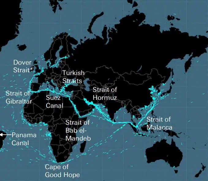
Ang mga cable, pipeline, kalsada, sea straits, air route at satellite ay bumubuo sa marupok na network kung saan itinayo ang pandaigdigang ekonomiya. Ang mga ito ay hindi nakikitang mga network na napakalaking kahalagahan sa pandaigdigang supply chain at modernong buhay, na, gayunpaman, ay naaalala lamang kapag ang isang digmaan tulad ng sa Ukraine o Israel ay nagbabanta sa isa sa mga estratehikong ito […]
DEEPSEA: next-generation voyage optimization na pinapagana ng Artificial Intelligence (AI) Gumamit ng Artificial Intelligence (AI) Performance Routing para agad na mapabilis ang decarbonization trajectory ng iyong fleet, at bawasan ang mga gastos sa gasolina. Ang Pagruruta ng Pagganap ay gagawa ng malaki, nasusukat na epekto sa pagkonsumo ng gasolina ng iyong fleet at CII ngayon, mga resultang may mataas na epekto mula sa unang araw. “Ang DeepSea Vessel Voyage Optimization AI Solution ay nagbabawas ng mga emisyon, […]
World's most famous Luxurious Marinas: Which are the most luxurious and popular marinas worldwide? Portofino, Monaco, St. Tropez, Ibiza, St. Barts. One of the first images that comes to mind when we think of these places are their iconic marinas. Dignitaries, powerful people of wealth, glamorous Hollywood stars and all those who have made yachting […]
Fishing is changing for the good of the Earth - advanced bio-based plastic solutions (By Tassoula Eptakili - www.kathimerini.gr) Almost 12 million tons of plastic waste end up in the world's oceans every year. Sometimes they travel in the water, creating huge underwater garbage dumps, and sometimes they come ashore. The effects of mindless consumption […]
Google - Data Centers Through 2022, Google has strengthened its commitment in Greece to accelerate sustainable and inclusive development and digital transformation, further intensifying its substantial support to the country. With strategic initiatives, and with a focus on people, the technology company opened a new important chapter in Greece with the announcement of the creation […]
Isang Daang Tao ng Lloyd's List, impluwensya sa pagraranggo at kapangyarihan sa loob ng pagpapadala Mahalaga pa rin ang mga indibidwal na aksyon sa pagpapadala, kahit na humihina ang kapangyarihan ng mga may-ari ng barko. Ngunit ang tiyak na sandali sa taong ito ay nagmula sa EU, na nalampasan ang IMO bilang ang pinaka-maimpluwensyang puwersa sa industriya, sa pamamagitan ng pagsasagawa ng nasasalat na aksyon upang matugunan ang pagbabago ng klima IT [...]
UKHO announced intention to end Paper Nautical Chart production (26 July 2022) (source: UK Hydrographic Office) The UK Hydrographic Office (UKHO) has announced on 26 July 2022 its intention to develop options for the withdrawal from global paper nautical chart production by late 2026 to increase focus on its digital navigation products and services. ("UKHO […]
Mula nang magsimula ang mga tao sa pagbuo ng mga kumplikadong bagay, napagtanto nila na kailangan ng isang sistema ng pagsukat . Orihinal na ang batayan ay ang katawan ng tao. Ang Rebolusyonaryong France ay gagawa ng kung ano ang nagbago sa tiyak na International System of Units (International Measurement System) Gumamit ang mga Ehipsiyo ng mga siko na mga 52,4 sentimetro, ngunit dahil […]
Ang Aegean Myth ng Arcadia Shipmanagement ay kinilala ng DNV bilang ang unang na-verify na SEEMP III vessel Classification society DNV ay nagpakita sa Arcadia Shipmanagement Co Ltd ng isang sertipiko na kinikilala ang kanilang sasakyang Aegean Myth bilang ang unang barko sa buong mundo na may SEEMP III manual. Ang Ship Operational Carbon Intensity Plan o SEEMP Part III, ay bahagi ng […]
Mula Agosto 2022, ang mga lumilipad na dolphin ng Hellenic Seaways, na nagdala ng dose-dosenang, kung hindi man daan-daang milyong mga pasaherong Greek at dayuhan sa Argosaronicos gulf sa nakalipas na limang dekada, ay mawawala sa kasaysayan. Nauugnay sa pang-unawa ng karamihan bilang maingay ngunit mabibilis na sasakyan para sa tag-araw at hindi lamang tumatakas, pangunahin sa Argosaronicos, […]
(Marine Shipping Glossary terms are offered by Hellenic Shipping News) press CTRL + F in your web browser to pop up the Search Bar and type the term you want to find... Maritime Dictionary app in Google Play Maritime Dictionary App Marine (app) in google Play Shipping Dictionary (app) in Google Play Naval Terms Dictionary […]
Mga Pagwawasto at Update sa Chart Luma, hindi na-update (mula pa sa ilang linggo) Ang mga Nautical Chart ay hindi dapat gamitin para sa maritime navigation at pagpaplano ng paglalakbay. Ang mga katangian ng isang ilog, sa partikular, na inilalarawan sa isang marine chart ay may posibilidad na patuloy na magbago, at ang mga artipisyal na tulong sa paglalayag sa dagat o baybayin ay maaaring mabago anumang oras. Bilang isang […]
NOAA's Nautical Paper Charts (Raster Nautical Charts: both paper and digital Raster Charts) will soon not be produced any more (by 2025) On April 13, the US federal government's National Oceanic & Atmospheric Administration (NOAA) announced it will soon stop printing traditional lithographic (paper) nautical charts - while other forms of nautical charts, such as […]
Mga serbisyo sa Web Map (paghahambing) Pinakatanyag na mga serbisyo sa Web Map Google Maps Bing Maps MapQuest OpenStreetMap Dito WeGo Apple Maps Yandex Maps Listahan ng paghahambing Tampok Google Maps Bing Maps MapQuest OpenStreetMap Dito WeGo Apple Maps Yandex Maps License Proprietary Proprietary Proprietary ODbL Proprietary Proprietary Proprietary Full functionality Australia, Canada, China, France, Germany, Israel, Italy, […]
A catalog of free (not necessarily Open Source) Satellite Navigation (or "GPS") software for a wide range of devices. (Navigation software with free maps - often uses maps from OpenStreetMap project) Satellite Navigation Software- Non-free maps Name Company Type of device[5] Operating system 3rd-party GPS-able?[6] Software with maps? Follows streets? Open-source? Remarks Aqua Map[29] GEC […]
ano ang mga abbreviation na ginamit sa Nautical Charts (Admiralty Charts / Maritime Charts) Bottom Characteristics and Abbreviations Nouns Source Chart Noun Abbreviation Abbreviation Boulders Blds Blds Clay Cl Cy Coral Co Co Coralhead Cl Hd Cl Hd Gravel GG Grass Grs Grs Mud MM […]
Filipinos: major source of Seafarers for the global maritime sector - One third of the world's seafarers are Filipinos. In the 1970s, the number of seafarers in traditional maritime countries dropped, resulting in a transfer of supply to countries such as India, China, and the Philippines. The Philippines has developed to become a significant producer […]
Ang isang sopistikadong bagong portal para sa mga nautical chart at publikasyon ay inilunsad na walang subscription o minimum na termino ng kontrata, at mga libreng update at pagwawasto. Tumutugon ang OpenC247.com sa lumalaking pangangailangan para sa mga digital na teknolohiya sa sektor ng maritime. Ang malambot na paglulunsad ng portal ay umakit ng higit sa 150 rehistradong gumagamit, mula sa mga kapitan ng super […]
European Digital Twin of the Ocean (European DTO) This tool will model the ocean and provide knowledge and understanding of the past and present and will create credible predictions of the ocean's future health. The ILIAD consortium will develop virtual representations of the sea that will integrate earth observing, modelling and digital infrastructures to provide […]
What is the Differences between VECTOR and RASTER Graphics? (right below its treated the difference Raster/Vector in regards to graphics - look further below for the difference between Vector Nautical Charts (VNC) and Raster Nautical Charts (RNC)) There is some confusion to many people when it comes to the differences between vector and raster graphics. […]
(* source: www.sailingissues.com - by Diederik Willemsen) Marine Navigation courses (FREE) Find advanced online course on marine navigation for offshore sailing. All though nowadays most sailors rely on maritime navigation and positioning equipment like the use of GPS / Galileo / GLONASS and Radars to navigate, by navigating by yourself is a lot more fun, Learn navigation to sail […]
(* source: NOAA - the National Oceanic and Atmospheric Administration (USA), the American scientific and regulatory agency - Symbols, Abbreviations and Terms used on Paper and Electronic Nautical Charts ENCs) Paper and Electronic Navigational Charts: Symbols, Abbreviations and Terms used on Marine Navigation Charts see a full list of symbols used on paper nautical charts […]
GLOSSARY of Nautical Charts, terms & abbreviations used in the maritime industry (* source: NOAA - the National Oceanic and Atmospheric Administration (USA), the American scientific and regulatory agency) An authoritative source for terms used in cartography (mapping), marine charting, and geodesy used in the nautical charting program. Terms and definitions are of specific cartographic […]
Hanapin ang lahat ng nangungunang provider ng mga produkto at serbisyo ng Marine Navigation para sa ligtas na Maritime Voyage Planning