Testing Sep 2025
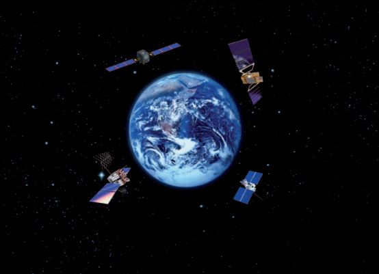
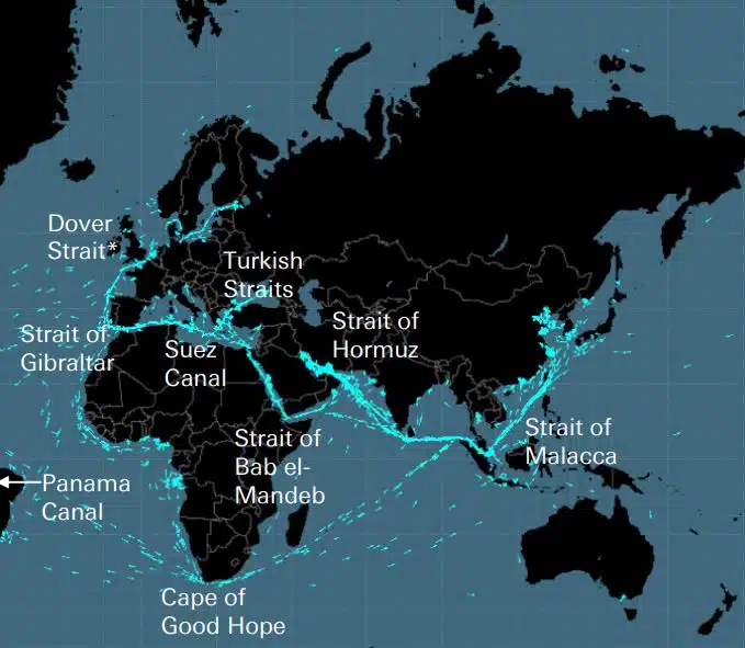
Кабелі, трубопроводи, дороги, морські протоки, повітряні маршрути та супутники утворюють крихку мережу, на якій побудована світова економіка. Це невидимі мережі, які мають величезне значення для глобального ланцюга поставок і сучасного життя, про які, однак, згадують лише тоді, коли війна, подібна до тієї, що в Україні чи Ізраїлі, загрожує одному з цих стратегічних […]
DEEPSEA: оптимізація подорожі наступного покоління на основі штучного інтелекту (ШІ) Використовуйте функцію штучного інтелекту (ШІ) Performance Routing, щоб миттєво прискорити траєкторію декарбонізації вашого флоту та зменшити витрати на паливо. Performance Routing зробить суттєвий, кількісно виміряний вплив на споживання палива та CII вашого автопарку вже сьогодні, результати з значним впливом з першого дня. «Рішення штучного інтелекту DeepSea Vessel Voyage Optimization зменшує викиди, […]
World's most famous Luxurious Marinas: Which are the most luxurious and popular marinas worldwide? Portofino, Monaco, St. Tropez, Ibiza, St. Barts. One of the first images that comes to mind when we think of these places are their iconic marinas. Dignitaries, powerful people of wealth, glamorous Hollywood stars and all those who have made yachting […]
Fishing is changing for the good of the Earth - advanced bio-based plastic solutions (By Tassoula Eptakili - www.kathimerini.gr) Almost 12 million tons of plastic waste end up in the world's oceans every year. Sometimes they travel in the water, creating huge underwater garbage dumps, and sometimes they come ashore. The effects of mindless consumption […]
Google - Data Centers Through 2022, Google has strengthened its commitment in Greece to accelerate sustainable and inclusive development and digital transformation, further intensifying its substantial support to the country. With strategic initiatives, and with a focus on people, the technology company opened a new important chapter in Greece with the announcement of the creation […]
Сто людей зі списку Ллойда, рейтинг впливу та влади в судноплавстві Індивідуальні дії все ще мають значення в судноплавстві, навіть якщо влада судновласників слабшає. Проте вирішальним моментом цього року став ЄС, який випередив IMO як найвпливовіша сила в галузі, вживаючи відчутних заходів для вирішення проблеми зміни клімату ІТ […]
UKHO announced intention to end Paper Nautical Chart production (26 July 2022) (source: UK Hydrographic Office) The UK Hydrographic Office (UKHO) has announced on 26 July 2022 its intention to develop options for the withdrawal from global paper nautical chart production by late 2026 to increase focus on its digital navigation products and services. ("UKHO […]
З тих пір, як люди почали будувати складні речі, вони зрозуміли, що існує потреба в системі вимірювання. Спочатку основою було тіло людини. Революційна Франція мала виробити те, що перетворилося на остаточну Міжнародну систему одиниць (Міжнародну систему вимірювання). Єгиптяни використовували лікті, які становили приблизно 52,4 сантиметри, але оскільки […]
Aegean Myth від Arcadia Shipmanagement було визнано DNV першим перевіреним судном SEEMP III. Класифікаційне товариство DNV вручило Arcadia Shipmanagement Co Ltd сертифікат, що визнає їхнє судно Aegean Myth першим у світі судном, яке має інструкцію SEEMP III. Експлуатаційний план викиду вуглецю на судні або SEEMP, частина III, є частиною […]
З серпня 2022 року літаючі дельфіни Hellenic Seaways, які за останні п’ять десятиліть перевезли десятки, якщо не сотні мільйонів грецьких та іноземних пасажирів у затоці Аргосаронікос, увійдуть в історію. Пов’язане зі сприйняттям більшості як галасливих, але швидких транспортних засобів для літа, а не лише для втечі, головним чином в Аргосаронікосі, […]
(Marine Shipping Glossary terms are offered by Hellenic Shipping News) press CTRL + F in your web browser to pop up the Search Bar and type the term you want to find... Maritime Dictionary app in Google Play Maritime Dictionary App Marine (app) in google Play Shipping Dictionary (app) in Google Play Naval Terms Dictionary […]
Виправлення та оновлення карт Старі, неоновлені (навіть кілька тижнів) морські карти ніколи не повинні використовуватися для морської навігації та планування рейсів. Характеристики річки, зокрема, зображені на морській карті, мають тенденцію постійно змінюватися, і штучні навігаційні засоби на морі або берегах можуть бути змінені в будь-який час. Як […]
NOAA's Nautical Paper Charts (Raster Nautical Charts: both paper and digital Raster Charts) will soon not be produced any more (by 2025) On April 13, the US federal government's National Oceanic & Atmospheric Administration (NOAA) announced it will soon stop printing traditional lithographic (paper) nautical charts - while other forms of nautical charts, such as […]
Картографічні веб-сервіси (порівняння) Найпопулярніші картографічні веб-сервіси Google Maps Bing Maps MapQuest OpenStreetMap Here WeGo Apple Maps Yandex Maps Список порівняння Функція Google Maps Bing Maps MapQuest OpenStreetMap Here WeGo Apple Maps Ліцензія Карти Yandex Proprietary Proprietary Proprietary Proprietary Propriet Propriet Propriet Додаткова функція ODbL Pro Австралія, Канада, Китай, Франція, Німеччина, Ізраїль, Італія, […]
A catalog of free (not necessarily Open Source) Satellite Navigation (or "GPS") software for a wide range of devices. (Navigation software with free maps - often uses maps from OpenStreetMap project) Satellite Navigation Software- Non-free maps Name Company Type of device[5] Operating system 3rd-party GPS-able?[6] Software with maps? Follows streets? Open-source? Remarks Aqua Map[29] GEC […]
які абревіатури використовуються в морських картах (адміралтейські карти / морські карти) Нижня характеристика та скорочення Іменники Джерело діаграми Абревіатура іменника Абревіатура Валуни Blds Blds Clay Cl Cy Coral Co Co Coralhead Cl Hd Cl Hd Гравій GG Grass Grs MM […]
Filipinos: major source of Seafarers for the global maritime sector - One third of the world's seafarers are Filipinos. In the 1970s, the number of seafarers in traditional maritime countries dropped, resulting in a transfer of supply to countries such as India, China, and the Philippines. The Philippines has developed to become a significant producer […]
Запущено новий складний портал для навігаційних карт і публікацій, який не має передплати чи мінімального терміну договору, а також безкоштовне оновлення та виправлення. OpenC247.com відповідає на зростаючий попит на цифрові технології в морському секторі. М’який запуск порталу залучив понад 150 зареєстрованих користувачів, від капітанів супер […]
European Digital Twin of the Ocean (European DTO) This tool will model the ocean and provide knowledge and understanding of the past and present and will create credible predictions of the ocean's future health. The ILIAD consortium will develop virtual representations of the sea that will integrate earth observing, modelling and digital infrastructures to provide […]
What is the Differences between VECTOR and RASTER Graphics? (right below its treated the difference Raster/Vector in regards to graphics - look further below for the difference between Vector Nautical Charts (VNC) and Raster Nautical Charts (RNC)) There is some confusion to many people when it comes to the differences between vector and raster graphics. […]
(* source: www.sailingissues.com - by Diederik Willemsen) Marine Navigation courses (FREE) Find advanced online course on marine navigation for offshore sailing. All though nowadays most sailors rely on maritime navigation and positioning equipment like the use of GPS / Galileo / GLONASS and Radars to navigate, by navigating by yourself is a lot more fun, Learn navigation to sail […]
(* source: NOAA - the National Oceanic and Atmospheric Administration (USA), the American scientific and regulatory agency - Symbols, Abbreviations and Terms used on Paper and Electronic Nautical Charts ENCs) Paper and Electronic Navigational Charts: Symbols, Abbreviations and Terms used on Marine Navigation Charts see a full list of symbols used on paper nautical charts […]
GLOSSARY of Nautical Charts, terms & abbreviations used in the maritime industry (* source: NOAA - the National Oceanic and Atmospheric Administration (USA), the American scientific and regulatory agency) An authoritative source for terms used in cartography (mapping), marine charting, and geodesy used in the nautical charting program. Terms and definitions are of specific cartographic […]
Знайдіть усіх провідних постачальників продуктів і послуг для морської навігації для безпечного планування морських подорожей