Testing Sep 2025
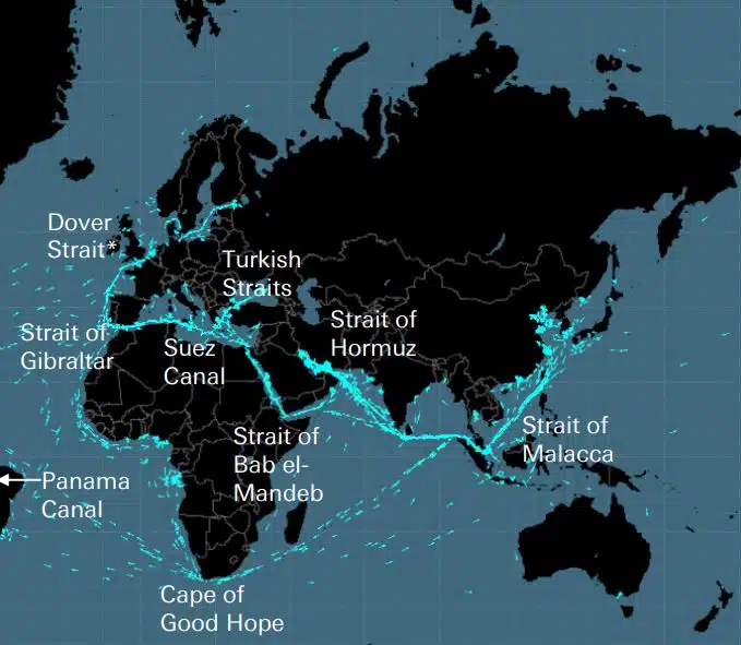
כבלים, צינורות, כבישים, מיצרי ים, נתיבי אוויר ולוויינים מהווים את הרשת השברירית שעליה בנויה הכלכלה העולמית. אלו הן רשתות בלתי נראות בעלות חשיבות עצומה לשרשרת האספקה העולמית והחיים המודרניים, אשר, עם זאת, זכורות רק כאשר מלחמה כמו זו באוקראינה או בישראל מאיימת על אחת מהאסטרטגיות הללו […]
DEEPSEA: אופטימיזציה של הפלגות מהדור הבא המופעלת על ידי בינה מלאכותית (AI) השתמש בניתוב ביצועים של בינה מלאכותית (AI) כדי להאיץ באופן מיידי את מסלול שחרור הפחמן של הצי שלך ולהפחית את עלויות הדלק. ניתוב ביצועים ישפיע משמעותית וניתנת לכימות על צריכת הדלק וה-CII של הצי שלך היום, תוצאות בעלות השפעה מהיום הראשון. "פתרון בינה מלאכותית לאופטימיזציה של מסעות כלי שיט עמוקים מפחית פליטות, […]
World's most famous Luxurious Marinas: Which are the most luxurious and popular marinas worldwide? Portofino, Monaco, St. Tropez, Ibiza, St. Barts. One of the first images that comes to mind when we think of these places are their iconic marinas. Dignitaries, powerful people of wealth, glamorous Hollywood stars and all those who have made yachting […]
Fishing is changing for the good of the Earth - advanced bio-based plastic solutions (By Tassoula Eptakili - www.kathimerini.gr) Almost 12 million tons of plastic waste end up in the world's oceans every year. Sometimes they travel in the water, creating huge underwater garbage dumps, and sometimes they come ashore. The effects of mindless consumption […]
Google - Data Centers Through 2022, Google has strengthened its commitment in Greece to accelerate sustainable and inclusive development and digital transformation, further intensifying its substantial support to the country. With strategic initiatives, and with a focus on people, the technology company opened a new important chapter in Greece with the announcement of the creation […]
מאה האנשים של לויד'ס רשימת, דירוג השפעה וכוח בספנות פעולות בודדות עדיין חשובות בספנות, אפילו כשכוחם של בעלי הספינות הולך ופוחת. עם זאת, הרגע המכונן של השנה הגיע מהאיחוד האירופי, שעקף את ה-IMO ככוח המשפיע ביותר בתעשייה, על ידי נקיטת פעולה מוחשית לטיפול בשינויי אקלים IT […]
UKHO announced intention to end Paper Nautical Chart production (26 July 2022) (source: UK Hydrographic Office) The UK Hydrographic Office (UKHO) has announced on 26 July 2022 its intention to develop options for the withdrawal from global paper nautical chart production by late 2026 to increase focus on its digital navigation products and services. ("UKHO […]
מאז שאנשים התחילו לבנות דברים מסובכים, הם הבינו שיש צורך במערכת מדידה. במקור הבסיס היה גוף האדם. צרפת המהפכנית הייתה אמורה לייצר את מה שהתפתח למערכת היחידות הבינלאומית (מערכת מדידה בינלאומית) המצרים השתמשו בקוביות שהיו בערך 52,4 סנטימטרים, אבל בגלל […]
ה-Aegean Myth של Arcadia Shipmanagement הוכר על ידי DNV כחברת סיווג כלי השיט SEEMP III המאומתת הראשונה DNV הציגה ל-Aradia Shipmanagement Co Ltd תעודה המזהה את כלי השיט שלהם Aegean Myth כספינה הראשונה בעולם שיש לה מדריך SEEMP III. תוכנית עוצמת הפחמן התפעולית של הספינה או SEEMP חלק III, היא חלק מ- […]
מאוגוסט 2022, הדולפינים המעופפים של Hellenic Seaways, אשר נשאו עשרות, אם לא מאות מיליוני נוסעים יוונים וזרים במפרץ ארגוסרוניקוס במהלך חמשת העשורים האחרונים, ייכנסו להיסטוריה. קשור לתפיסה של רוב כלי רכב רועשים אך מהירים לקיץ ולא רק בריחות, בעיקר ב-Argosaronicos, […]
(Marine Shipping Glossary terms are offered by Hellenic Shipping News) press CTRL + F in your web browser to pop up the Search Bar and type the term you want to find... Maritime Dictionary app in Google Play Maritime Dictionary App Marine (app) in google Play Shipping Dictionary (app) in Google Play Naval Terms Dictionary […]
תיקוני תרשים ועדכונים ישנים, לא מעודכנים (מאז כמה שבועות) לעולם אין להשתמש בתרשימים ימיים עבור ניווט ימי ותכנון מסע. המאפיינים של נהר, במיוחד, המתוארים במפה ימית נוטים להשתנות ללא הרף, ועזרי ניווט מלאכותיים בים או בחופים עשויים להשתנות בכל עת. כ […]
NOAA's Nautical Paper Charts (Raster Nautical Charts: both paper and digital Raster Charts) will soon not be produced any more (by 2025) On April 13, the US federal government's National Oceanic & Atmospheric Administration (NOAA) announced it will soon stop printing traditional lithographic (paper) nautical charts - while other forms of nautical charts, such as […]
שירותי מפות אינטרנט (השוואה) שירותי מפות אינטרנט הפופולריים ביותר שירותי מפות אינטרנט Google Maps Bing Maps MapQuest OpenStreetMap Here WeGo Apple Maps Yandex Maps רשימת השוואת תכונה Google Maps Bing Maps MapQuest OpenStreetMap כאן WeGo Apple Maps Yandex Maps רישיון קנייני קנייני קנייני ODbL קנייני פונקציונלי קנייני מלא אוסטרליה, קנדה, סין, צרפת, גרמניה, ישראל, איטליה, […]
A catalog of free (not necessarily Open Source) Satellite Navigation (or "GPS") software for a wide range of devices. (Navigation software with free maps - often uses maps from OpenStreetMap project) Satellite Navigation Software- Non-free maps Name Company Type of device[5] Operating system 3rd-party GPS-able?[6] Software with maps? Follows streets? Open-source? Remarks Aqua Map[29] GEC […]
מהם הקיצורים המשמשים בתרשימים ימיים (תרשימים אדמירליות / תרשימים ימיים) מאפיינים תחתונים וקיצורים תרשים מקור שמות עצם קיצור קיצור קיצור Boulders Blds Blds Clay Cl Cy Coral Co Co Coralhead Cl Hd Cl Hd Gravel GG Grass Grs Grs Mud […]
Filipinos: major source of Seafarers for the global maritime sector - One third of the world's seafarers are Filipinos. In the 1970s, the number of seafarers in traditional maritime countries dropped, resulting in a transfer of supply to countries such as India, China, and the Philippines. The Philippines has developed to become a significant producer […]
הושק פורטל חדש ומתוחכם לתרשימים ופרסומים ימיים שאין לו מנוי או תקופת חוזה מינימלית, ועדכונים ותיקונים בחינם. OpenC247.com עונה לביקוש הגובר לטכנולוגיות דיגיטליות במגזר הימי. ההשקה הרכה של הפורטל משכה יותר מ-150 משתמשים רשומים, מקפטנים של סופר […]
European Digital Twin of the Ocean (European DTO) This tool will model the ocean and provide knowledge and understanding of the past and present and will create credible predictions of the ocean's future health. The ILIAD consortium will develop virtual representations of the sea that will integrate earth observing, modelling and digital infrastructures to provide […]
What is the Differences between VECTOR and RASTER Graphics? (right below its treated the difference Raster/Vector in regards to graphics - look further below for the difference between Vector Nautical Charts (VNC) and Raster Nautical Charts (RNC)) There is some confusion to many people when it comes to the differences between vector and raster graphics. […]
(* source: www.sailingissues.com - by Diederik Willemsen) Marine Navigation courses (FREE) Find advanced online course on marine navigation for offshore sailing. All though nowadays most sailors rely on maritime navigation and positioning equipment like the use of GPS / Galileo / GLONASS and Radars to navigate, by navigating by yourself is a lot more fun, Learn navigation to sail […]
(* source: NOAA - the National Oceanic and Atmospheric Administration (USA), the American scientific and regulatory agency - Symbols, Abbreviations and Terms used on Paper and Electronic Nautical Charts ENCs) Paper and Electronic Navigational Charts: Symbols, Abbreviations and Terms used on Marine Navigation Charts see a full list of symbols used on paper nautical charts […]
מילון מונחים של מפות ימיות, מונחים וקיצורים המשמשים בתעשייה הימית (*מקור: NOAA - המינהל הלאומי לאוקיינוסים ואטמוספירה (ארה"ב), הסוכנות המדעית והרגולטורית האמריקאית) מקור סמכותי למונחים המשמשים בקרטוגרפיה (מיפוי), מיפוי ימי וגיאודזיה המשמשים בתוכנית המיפוי הימי. מונחים והגדרות הם של קרטוגרפיה ספציפית […]
מצא את כל הספקים המובילים של מוצרים ושירותי ניווט ימי לתכנון מסע ימי בטוח