catalogue of a selection of the best marine navigation Apps for boaters, sailors and marine people: boats, cruise ships, yachts and superyachts and commercial ship vessels

Best Marine Navigation Apps

marine navigation app - c map

C-MAP

The C-MAP app provides high-quality nautical maps along with navigation, traffic and weather information to help you plan your next trip on the water.

Chart Features: Weather Along the Route - HRB with Autorouting - Points of Interest - Custom Depth Shading

Autorouting - Points of Interest - High Resolution Bathymetry - Custom Depth Shading - GPX Import & Export - Anchoring Alert

Free Download of C-MAP App:
C-MAP marine app on iTunes App Store 
C-MAP marine app on Google Play
C-MAP marine navigation app
marine navigation app - Navionics boating App

Navionics Boating app

Navionics lays claim to being the most popular boating app available, and its navigational features and functions are comprehensive, to say the least. In fact, it offers many features that some modern chartplotters can’t match. Navionics Marine & Lakes is one of the best navigation apps available for Android and IOS devices. Incorporates the excellent Navionics Gold vector charts with map, satellite and terrain overlays, all for free.  Navionics Marine & Lakes app is free (you need though to purchase local marine chart regions and other upgrades). If you already have Navionics Marine & Lakes app, it will update your Navionics Boating app for free.
NAVIONICS marine navigation app
marine navigation app - Savvy Navvy App

Savvy Navvy

Savvy Navvy marine navigation app is a Google maps for boats - savvy navvy gives you charts, tides, weather, everything you need for sailing and motorboat navigation in one place. Llicences UKHO, NOAA and other official hydrographic office marine charts from around the globe. App is build from the ground up to show essential marine information with a clean and easy-to-view interface. Offers tide data from over 8,000 tidal stations around the world, GPS Active Tracking, Wind Maps, Weather Forecast, Route Planning, Fuel Efficiency and many more great features.

Savvy Navvy navigation app in Google Store
Savvy Navvy navigation app in Apple store
SAVVY NAVVY navigation app
marine navigation app - Seapilot

Seapilot

Seapilot app is free to download and incorporates professional navigation technologies, AIS boat tracking and up-to-date nautical charts. Seapilot Navigation App uses vectorized S-57 chart data from national maritime administrations from 25 countries. Nautical charts are purchased directly in the Seapilot app. Features Automatic Identification System (AIS) and built in weather forecasts, when within a mobile network.

SEAPILOT navigation app in Google Store
SEAPILOT navigation app in Apple store
SEAPILOT marine navigation app
marine navigation app - iSalor

iSailor

Wärtsilä iSailor is an easy-to-use marine and river navigation application for amateur seafarers. iSailor provides a clear presentation of navigational information, electronic charts and additional content. Works well as an extension to your boat's onboard systems. It will connect to the NMEA system and internet AIS.
iSALOR marine navigation app
marine navigation app - inavx

iNavx

iNavx is a very popular (handheld) chartplotter app that works on both iOS and Android devices. Pay a small charge to download the iNavx app, you can then download NOAA raster charts for free. iNavX works also with vector charts, including nautical charts from Navionics, Waterway Guides, NV Charts, and more, (extra charge applies for downloading these)
iNAVX marine navigation app
marine navigation app - Garmin blue chart

Garmin Blue Chart

Garmin offer a suite of 9 marine navigation apps, Garmin's BlueChart Mobile is among the quickest to learn marine navigation apps by punching around on the buttons and menus and the easiest to use once you are familiarized. All navigation functions one would expect are available on Garmin BlueChart Mobile.
GARMIN marine navigation app
marine navigation app -  SeaNav

SeaNav

Use SeaNav to plan and sail routes. In-app tools let you measure distances and bearings and record waypoints on routes to sail. Explore, plan and navigate your boating trips in real time and outstanding high-resolution using digital charts derived from the latest NOAA and UKHO data.
SEANAV marine navigation app
MAPTECH iplot - marine navigation app

Maptech iPlot

The Maptech iPlot app is simple to use chart plotter app that utilizes many of the same routing functions that Maptech uses in their digital software.
iPLOT marine navigation app
MX MARINER - marine navigation app

MX Mariner

MX Mariner is an easy to use mobile marine navigator / chart plotter.
MX MARINER navigation app
ARGO - marine navigation app

Argo app

Argo is a FREE easy-to-use navigation and social boating app that helps you find and route to new destinations, share local knowledge, and connect with other boaters. Argo marine navigation app is Free to Download & Use, you get navigation and routing, local boating knowledge and social boating features all in one app.
ARGO marine navigation app
Marinetraffic ship navigation tracking app

MarineTraffic ship tracking app

MarineTraffic displays near real-time positions of ships and yachts worldwide. Connected to the largest network of land-based AIS receivers, the app covers most major ports and shipping routes. MarineTraffic Live Ships Map: discover information and vessel positions for vessels around the world.
MarineTraffic ship locating app
Navily - marine navigation app

Navily app

Navily - Your Cruising Guide: with more than 500.000 users worldwide, Navily app is the ideal companion for all your boat trips :
- Cruising guide with 25.000+ marinas and anchorages
- 200.000 photos and comments from the community
- Easy booking in 700+ marinas across Europe
- InApp chat with users and marinas
- Real time warnings on anchorages and Emergency SOS feature with the community
NAVILY marine navigation app
NV Charts App - marine navigation app

NV Charts GPS Navigation AIS

MarineTraffic displays near real-time positions of ships and yachts worldwide. Connected to the largest network of land-based AIS receivers, the app covers most major ports and shipping routes. MarineTraffic Live Ships Map: discover information and vessel positions for vessels around the world.
NV Charts GPS Navigation AIS app
i-Boating Marine Navigation app

i-Boating Navigation app

i-Boating Marine Charts & Lake Maps GPS App offers offline nautical charts, inland river navigation charts, and lake contour maps for kayaking, yachting & sailing.
First marine navigation app to have boat route assistance with Voice Prompts. All features of a Marine Chart plotter in one app! It supports Nautical Charts course up orientation. i-Boating Marine Charts App includes Tide Charts & Currents prediction for nautical navigation. Create new boat routes / waypoints, or import existing GPX/KML routes on device. Has Marine AIS (NMEA) support.
i-Boating marine navigation app
WinGPS marine navigation app

WinGPS™ Marine

WinGPS Marine app helps you unlock the full capabilities of your personal navigation system. You will be able to plot routes, download GRIB files, save previous tracks and connect AIS and GPS. Use the handy time table to view the predicted wind, rain, air pressure and AIS targets
WinGPS™ marine navigation app
Marine Navigation AppsApple Store - nautical applications previewBest Marine Navigation Apps

Various Applications / marine navigation apps


Argo - Boating Navigation

BaseMap: Hunting GPS Maps

C-MAP: Boating

Dockwa

Earthmate

Freedom Boat Club

Garmin ActiveCaptain®

i-Boating: Marine Charts & Gps

iNavX: Marine Navigation

KnowWake

Link: Connect Your Boat

Lowrance: Fishing & Navigation

MarineTraffic - Ship Tracking

Polaris®

PRO CHARTS - Marine Navigation

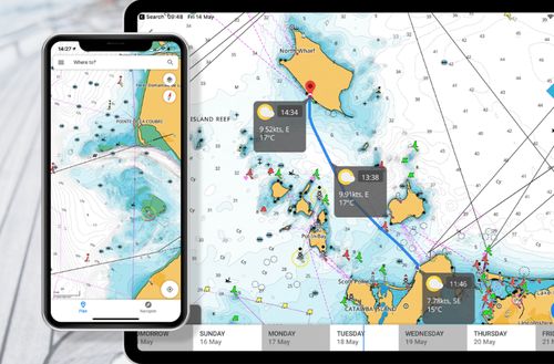
savvy navvy - Smarter Boating

Simrad: Boating & Navigation

TZ iBoat – Marine Navigation

VesselView Mobile

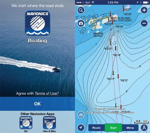
Wavve Boating: Easy Marine GPS

Various Applications / marine navigation apps


More sources related to Marine Navigation Apps

Maritime Navigation

Comparison of free off-line satellite navigation software

List with free (not necessarily open source) Satellite Navigation (or "GPS") software for a range of devices (PC, laptop, tablet, mobile phone, handheld PC (Pocket PC, Palm))

(SOURCE: Wikipedia: Comparison of free off-line satellite navigation software)

Satellite navigation software

Satellite navigation software or GPS navigation software usually falls into one of the following two categories:

Navigation with route calculation and directions from the software to the user of the route to take, based on a vector-based map, normally for motorized vehicles with some motorized forms added on as an afterthought.

 Navigation tracking, often with a map "picture" in the background, but showing where you have been, and allowing "routes" to be preprogrammed, giving a line you can follow on the screen. This type can also be used for geocaching.

(SOURCE: Wikipedia: Satellite Navigation Software)
Everything You Need For Your Back Of Bridge Maritime Voyage Planning, Nautical Navigation and the Marine Sector in General

Maritime Navigation Services and Products DIRECTORY

DIGITAL Nautical Charts

list of the best marine electronic chart solutions, digital vector and raster maritime navigation charts for your passage planning, from commercial ships to leisure vessels
SEE MORE

PAPER Nautical Charts

list of the best printed marine chart providers & paper nautical charts sales agents worldwide for all needs: voyage planning for commercial fleets, leisure ships, yachts, superyachts
SEE MORE

Nautical Charts CORRECTIONS

selection of nautical charts corrections & updates solutions from premium providers across the globe. A critical service for safe passage planning everywhere in the sea world
SEE MORE

Nautical PUBLICATIONS

directory list of selected premium Nautical Publications, paper and digital marine publications from the best providers worldwide to help mariners with day to day passage plan
SEE MORE

Find all top providers of Marine Navigation products & services for safe Maritime Voyage Planning

apartmentpencilcogfilm-playbookmaptabletlaptop-phoneearth
en_USEnglish