DIRECTORY OF Paper Nautical Charts, also called Standard Nautical Charts (SNC) marine charts
Paper nautical charts

Paper Nautical Charts (also called Standard Nautical Charts - SNC)

a Nautical Chart is a graphic representation of a sea area and adjacent coastal regions. Depending on the scale of the chart, it may show depths of water and heights of land (topographic map), natural features of the seabed, details of the coastline, navigational hazards, locations of natural and human-made aids to navigation, information on tides and currents, local details of the Earth's magnetic field, and human-made structures such as harbors, buildings, and bridges. Nautical Charts are essential tools for marine navigation; many countries require vessels, especially commercial ships, to carry them. Nautical charting may take the form of charts printed on paper (raster navigational charts - RNC) or computerized electronic navigational charts (ENC). Recent technologies have made available paper charts which are printed "on demand" with cartographic data that has been downloaded to the commercial printing company as recently as the night before printing. With each daily download, critical data such as Local Notices to Mariners are added to the on-demand chart files so that these charts are up to date at the time of printing.

(SOURCE: Wikipedia - Nautical Charts)
marine charts - background image

List of sources of PAPER Nautical Charts providers & manufacturers (Standard Nautical Charts SNCs)

NAVTOR nautical charts

Navtor Paper Charts

an International Admiralty Chart Agent, NAVTOR Nautic carries an extensive array of maritime products. Worldwide coverage of Paper Charts and marine publications are always kept in stock, as are publications from IMO, ITU, and other UN organisations
Lyssos paper nautical charts

Lyssos Enterprises - paper charts

Lyssos Enterprises has a wide and more than 30 years' accredited experience. Full range of Admiralty paper publications stocked including mandatory titles such as Sailing Directions, List of Radio Signals, List of Lights, Tide Tables, as well as other Admiralty titles including "The Mariners Handbook"
VANOS nautical charts

Vanos Paper Charts

Vanos has divided the World Map in 30 distinguished folios of Paper Nautical Charts for easy guidance. This can be used in case you require us to monitor specific Voyage Areas of your fleet


Kartverket Norway - Norvegian nautical charts

Kartverket - Norvegian nautical charts

Kartverket - the General Chart Series comprises a total of 12 charts, covering the North Sea, the Norwegian Sea, Svalbard, the Barents Sea, the Greenland Sea, Iceland, Eastern Greenland, the North Atlantic and Antarctica
Australian Hydrographic Office

Australian Hydrographic Office (AHO) - paper charts

the Australian Hydrographic Office (AHO) publishes and updates official paper nautical charts.Aus Paper Charts. Coverage includes:
- Australian, Timor Leste and Australian Antarctic Territory waters published as 'Aus' charts - Papua New Guinea waters published as ‘PNG’ charts - Solomon Islands waters published as 'SLB' charts.
AHO paper charts are official nautical products published by the Australian Hydrographic Office (AHO), Australia’s national charting authority
Riviera Charts, Nautical Stationary & Flags

Riviera Charts - paper nautical charts

Riviera Charts maintains a substantial stock of official paper charts published by British ADMIRALTY and French SHOM. ADMIRALTY standard paper nautical charts comply with Safety of Life at Sea (SOLAS chapter V) regulations and are the de facto standard for commercial shipping, useful for passage planning, ocean crossings, coastal navigation and entering port. Paper and digital navigation and publication solutions. Riviera Charts also operates a print on demand service (POD)

For leisure navigators, Riviera Charts also distributes charts from suppliers including: Imray, Eagle Ray, SHOM, NV Charts
Admiralty - digital nautical charts (ENCs)

ADMIRALTY Paper Charts

ADMIRALTY comprehensive, official paper marine navigational chart coverage of the world's commercial shipping routes & ports, an extensive range of planning charts to support passage planning tasks. UK Hydrographic Office (UKHO) is a world-leading hydrography centre, specialising in marine geospatial data. Admiralty Standard Nautical Charts (SNCs) offers over 3.500 paper charts. ​​​​​​​​​​Its Standard Nautical Charts (SNCs) are the world's most trusted, widely used official paper charts. The range includes comprehensive paper coverage of commercial shipping routes, ports and harbours to help bridge crews safely navigate in accordance with SOLAS regulations
SHOM French marine charts

French Hydrographic Service (HNHS)

Paper nautical charts by the French Naval Hydrographic and Oceanographic Service (SHOM). SHOM performs general hydrography duties for all seafarers to meet France’s international obligations under the international SOLAS Convention for the Safety of Life at Sea and the United Nations convention on the Law of the Sea. SHOM collects, archives produces and distributes official information necessary for maritime navigation. Shom produces the nautical charts & nautical works necessary to ensure the safety of navigation in French maritime areas as well as the areas under the cartographic responsibility of France. Shom has a catalog of paper charts
TODD marine navigation

TODD Navigation Charts

TODD paper charts: Admiralty Standard Nautical Charts (SNCs) are the world's most trusted and widely used official paper nautical charts. The charts range includes comprehensive paper coverage of commercial shipping routes, ports and harbours to help bridge crews safely navigate in accordance with SOLAS regulations. Over 3.500 nautical charts with coverage appropriate for navigation of deep sea, coastal passages, port approaches and harbour berthing
Imray marine paper charts

IMRAY Paper Charts

Imray Nautical paper charts for leisure sailors: Imray skilled cartographers customise the latest official data from international Hydrographic Offices including UKHO, SHOM, BSH to show the most relevant information for leisure and small craft sailors. Paper Nautical Charts are printed on water-resistant paper designed for sailors and packaged in a sturdy recycled PVC wallet
AMnautical American Nautical Services

AMnautical - American Nautical Services

AMnautical provides over 3.500 Admiralty standard nautical charts (SNCs) with coverage appropriate for navigation of deep sea, coastal passages, port approaches and harbour berthing. A range of scales to provide appropriate levels of detail and increase situational awareness, including: Large-scale Paper Nautical Charts (PNCs) for main ports and harbours, medium scale charts for coastal navigation and small-scale charts for offshore navigation. Weekly updates and new editions to help maintain high levels of accuracy, safety & compliance
Danish Hydrographic Office - Danish Geodata Agency-500x259

Danish GeoData Agency

Paper Charts of the Danish waters and around Greenland, are published when deemed necessary. This happens when either the number or complexity of corrections dictates a new print or the chart is sold out. The Danish waters are covered by 63 marine charts and the waters around Greenland are covered by 94 charts. Great circle charts - Harbour charts & Special scale charts - Approach Charts - Coastal Charts - Passage/landfall Charts

Hartis marine paper charts

Hartis paper marine chart

HARTIS Paper Nautical Charts (PNC) for the Greek seas. Guides and Paper Marine Navigational Charts for Sailing in Greece.

Nautical charts are the most important aid for the navigator. However, it is important that they are used in conjunction with nautical instructions (Pilot), an essential supplement to nautical charts.
Also offfers authentic copies of the first, antic Nautical Charts published by the Hellenic Navy Hydrographic Service
NOAA - National Oceanic Atmospheric Administration

NOAA paper charts

The US Office of Coast Survey (OCS) has been involved in the development NOAA's paper navigational charts in four formats: Paper nautical chart - Full-size nautical chart - BookletChart™ - Raster navigational chart (RNC). Note: All traditional NOAA's paper nautical charts will be canceled by Jan 2025. NOAA has stopped making charts and will shut down all production, maintenance of paper charts, the associated raster chart products & services by 2025. Mariners are encouraged to use the electronic nautical charts (NOAA ENC®)
HNHS - Hellenic Navy Hydrographic Service

HNHS - Hellenic Navy Hydrographic Service (Greece) 

HNHS produces Paper Nautical Charts (PNC), which are in line with IMO’s Safety of Life at Sea (SOLAS) provisions and with IHO’s S-4 standard. HNHS’s paper charts are suitable for both professional use (by vessels not required to use ECDIS) and recreational shipping (leisure boats). The Greek Paper Nautical Charts folio includes a total of 184 charts in various scales which cover the entire Greek territory. Updates are provided monthly by issuing Notices to Mariners (NtM) publications
Electronic Marine Charts by openc247

OpenC247 paper charts

OpenC247 Paper Nautical Charts (PNCs), Chart Corrections and Marine Publications. No Subscription. No Commitment. Complete Flexibility - 24/7. OpenC247 marine charts are available online 365/24/7 on any device (mobile / tablet / desktop). A fresh concept in access to Paper or Digital Charts and Publications for your bridge. Perfect for every captain of a leisure or commercial ship, any vessel – from a super yacht to a super tanker
stanfords maritime paper maps

Stanfords nautical charts

Stanfords paper nautical charts (PNCs). UK's leading specialist retailer of printed nautical maps, travel books and other travel accessories (Ordnance Survey mapping for professionals and planning applications). Established in 1853 by Edward Stanford. After 118 years at our Long Acre address our flagship store relocated to our new London home in Covent Garden, where we pride ourselves on the depth of our stock, sourced by experts, from all over the world. Expanding range of both paper mapping and map data for businesses
NV nautical digital charts ENC

NV Charts

For more than 40 years, NVcharts Nautical Publications’ team of hydrographers, cartographers, geographers and professional mariners has been producing paper charts of the Baltic Sea, European Inland Waters, the Mediterranean, the Caribbean, the Bahamas and since 2009 of the US east coast by conducting their own surveys and designing charts. NV Charts nautical charts are remarkably detailed nautical charts of high quality
Canadian Hydrographic Service ENCs

Canadian Hydrographic Service

Paper nautical charts, publications and survey results from the Canadian Hydrographic Service. Purchase paper marine charts for navigational use or download sample charts in a various formats. Canadian Hydrographic Service offers a wide range of nautical publications that are indispensable companions to charts, enhancing safety at sea
JHA - Japan Hydrographic Association

JHA - Japan Hydrographic Association 

Marine charts (PNCs) for Japan by the Japanese Japan Hydrographic Association (Japan Hydrographic Office), a public corporation distributing marine charts, nautical publications, marine data, and does R&D maritime rleated activities. Visit Japan's Nautical Chart Web Shop, search for Japanese Charts by main ports and routes to get your Paper Navigational Charts and Maritime Publications online
Nautical Charts Online

NauticalChartsOnline

NauticalChartsOnline paper marine charts collection, NOAA and international navigational paper charts. For over a decade, Nautical Charts Online has worked as an experienced printer to provide boaters with a vast selection of charts to help them navigate safely. In order to ensure that boaters always have the most up-to-date charts, Nautical Charts Online offers print-on-demand charts. Plus, Specialty Charts - Hurricane - Bathymetric - Historical - Training Charts - Canoe Charts - Satellite Charts


Novaco Bridge nautical charts

Novaco bridge charts

Novaco charts offers up-to-date nautical charts. Access all the catalogues of charts and publications published by the Admiralty, other hydrographic offices and public or private organisations. Catalogues are updated weekly and help identify new editions as they emerge. 

Novaco’s Instant Permit Service (IPS) provides new permit files to unlock ADMIRALTY AVCS, ADP and AeNP products instantly

OceanGrafix paper marine charts (PNC) - Standard Nautical Charts (SNCs) for mariners

OceanGrafix paper charts

Minnesota-based OceanGrafix provides commercial and recreational boaters with the very best in nautical charts. From NOAA navigational charts to those used for hurricane tracking, we pride ourselves on consistently providing high quality products that help keep boaters safe - and improve their boating experience. OceanGrafix provides the most accurate, up to date nautical paper charts for NOAA, NGA, Historical, Bathymetric, Hurricane and more
Maryland Nautical

Maryland Nautical - paper marine charts 

Maryland Nautical has in stock a worldwide selection of Nautical Charts - British Admiralty, OceanGrafix NOAA print on demand charts, Canadian Hydrographic Service standard nautical charts (SNCs) & much more. Maryland Nautical is one of the largest nautical chart agents in the United States. Online purchase of nautical charts, books and other navigational resources
Mexican Hydrographic Office charts (SEMAR - Secretaría de Marina Armada de México)

SEMAR - Secretaría de Marina Armada de México

Mexican Hydrographic Office charts SEMAR (Secretaría de Marina Armada de México). Paper Marine charts for Mexican seas and surounding areas - paper marine navigation charts for the coastlines and coastal waters of Mexico 
West Marine nautical charts

Westmarine paper charts

Westmarine Print-On-Demand paper charts: provide the latest updated information, and have become the standard for timely accuracy. Westmarine paper charts include all the latest local & regional Notices To Mariners corrections, accurate at the time of printing. Because of this guaranteed up-to-date accuracy, they add an important level of safety for mariners (charts are approved by NOAA, meet USCG carriage requirements for commercial vessels, and are SOLAS compliant)
Danish Hydrographic Office marine charts

Danish Hydrographic Office - paper charts

Danish Nautical charts by DHO (Danish Hydrographic Office). The nautical chart catalog of the Danish Hydrographic Office offers a very complete selection of Greenland nautical charts that comply with SOLAS regulations (Safety of Life at Sea) and are perfectly suitable for professional, commercial or leisure use
HKHO Honk Kong Hydrographic Office

Hong Kong Hydrographic Office - paper charts

Hong Kong Hydrographic Office Paper Charts - bilingual (Chinese and English) paper nautical charts are produced in accordance with the specifications of the International Hydrographic Organization (IHO). The positions on the chart are referred to the WGS84 Datum. The depths are in metres and reduced to the Chart Datum, which is approximately the Lowest Astronomical Tide. The buoyage system in Hong Kong follows the IALA Maritime Buoyage System (Region A)
BSH Federal Maritime and Hydrographic Agency

BSH - Federal Maritime and Hydrographic Agency

Paper charts of the BSH, the BSH produces printed nautical charts for the territory covered by the German Traffic Regulations for Navigable Maritime Waterways. Paper charts depict, among other things, sea routes, coastlines, navigational aids, depth information, obstructions, prohibited areas in a certain sea area to enable safe navigation and planning for shipping (includes rivers, the territorial sea, the German EEZ, including some areas of neighbouring countries)
Maptech marine maps

MapTech Nautical Maps

Maptech® is the publisher of Maptech® ChartKits®, Richardsons' Chartbooks, Embassy Cruising Guides, and Maptech® Marine navigation software and Electronic Charts.
Maptech® Waterproof Chartbooks & Marine Digital Software. Maptech's ChartKit® books are color reproductions of NOAA marine charts bundled together in large cruising regions. ChartKit® has been a mainstay of boating for generations (more than 1 million ChartKit® books have been sold in the past 40 years)
Captainsnautical standard nautical charts SNC

Captainsnautical paper charts

Captain's Supplies (Captain's Nautical Books & Charts) is the oldest nautical chart dealer in Seattle. Today, is a Print-On-Demand dealer of up-to-date NOAA Marine Charts, Canadian Charts, and British Admiralty Charts. CaptainsNautical also carry Imray recreational cruising charts, NGA worldwide charts, bathymetric fishing charts. An ISO 9001 Certified Company
DEFENDER Waterproof Chart Books

DEFENDER Waterproof Chart Books

Waterproof Chartbooks Navigational Charts: go old school with paper marine charts (standard Nautical Charts SNCs) for just about any navigable area from the Pacific Northwest to the Bahamas to the Coastal Canadian Maritimes. 

Chart sleeves and zippers chart bags are available to protect your chart books or go wild with waterproof chart books or folded waterproof charts

LIST OF NATIONAL HYDROGRAPHIC OFFICES WORLDWIDE

search more paper marine navigational charts (PNCs) all over the world in the full catalogue of National Hydrographic Offices worldwide and find their accredited paper charts selling agent that supplies their charts - HYDROGRAPHIC OFFICES
Paper Nautical Standard Charts

Use of Digital Nautical Charts (ENCs) is increasing - while use of Paper Nautical Charts is in serious decline...

Whilst ENC (electronic nautical charts) use is constantly increasing, the use of traditional paper nautical charts is decreasing. Sales of NOAA paper nautical charts have dropped nearly 60% since 2010, sustaining a downward trend that started over two decades ago (see Figures below). The IHO Nautical Cartography Working Group documented similar declining sales of paper charts published by many other hydrographic offices around the world in their “Future of the Paper Nautical Chart Final Report”, released in August 2020.

USA - NOAA Paper Nautical Chart sales 2000-2020

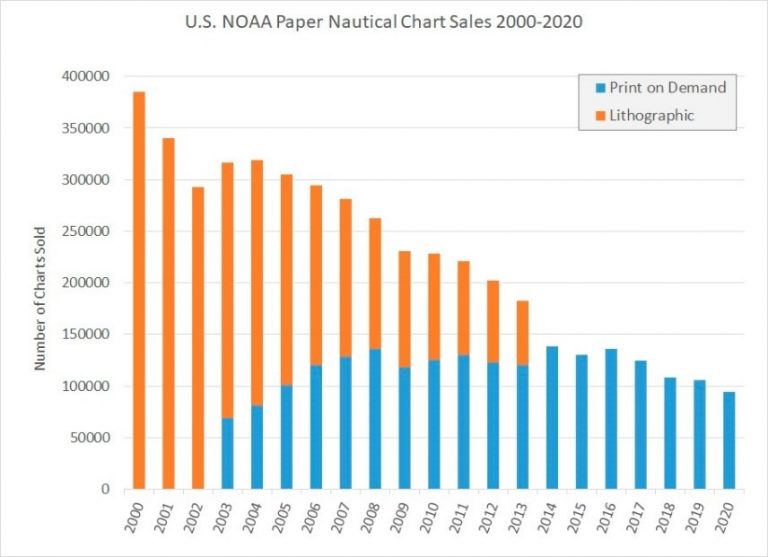
(Stats figures by N.O.A.A.) - NOAA has distributed paper nautical charts exclusively through commercial print -on-demand partners since 2014. Sales of both lithographic and print-on-demand paper charts have been declining for over two decades as the sales stats above demonstrate.
Guided by these trends, NOAA initiated a program to phase out its traditional paper nautical charts and their corresponding raster chart products and services

(source: International Hydrographic Organization (IHO) - https://ihr.iho.int/articles/the-end-of-traditional-paper-charts-the-final-transition-to-electronic-navigational-charts/ )

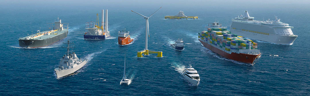
ENC data is produced by many countries and used by mariners around the world. In addition to the ECDIS (Electronic Chart Display & Information Systems) equipment used by large ocean-going vessels, ENCs can also be used in a growing variety of electronic chart systems (ECS), chart plotters, and mobile devices by professional mariners and leisure craft owners alike. Use of ENCs also enables real-time vessel positioning and automated alarms or indications of unsafe conditions during voyage planning and while underway – safety features that paper charts cannot provide. These are clear indications that ENCs are already an important part of the marine navigation “ecosystem” and will be even more so in the future.

Whilst ENC (electronic nautical charts) use is constantly increasing, the use of traditional paper nautical charts is decreasing. Sales of NOAA paper nautical charts have dropped nearly 60% since 2010, sustaining a downward trend that started over two decades ago (see Figures below). The IHO Nautical Cartography Working Group documented similar declining sales of paper charts published by many other hydrographic offices around the world in their “Future of the Paper Nautical Chart Final Report”, released in August 2020.

Antic marine navigation charts

Sources and Publication of Nautical Charts

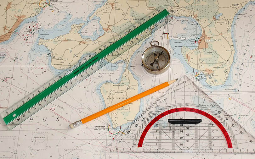
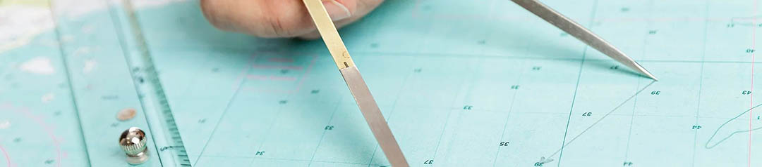
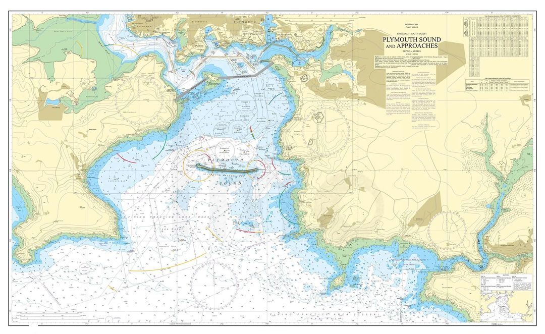
Nautical Charts (Paper Nautical Charts / Standard Nautical Charts (SNC)) are based on hydrographic surveys. As surveying is laborious and time-consuming, hydrographic data for many areas of sea may be dated and are sometimes unreliable. Depths are measured in a variety of ways. Historically the sounding line was used. In modern times, echo sounding is used for measuring the seabed in the open sea. When measuring the safe depth of water over an entire obstruction, such as a shipwreck, the minimum depth is checked by sweeping the area with a length of horizontal wire. This ensures that difficult to find projections, such as masts, do not present a danger to vessels navigating over the obstruction.

Nautical charts are issued by power of the National Hydrographic Offices in many countries. These charts are considered "official" in contrast to those made by commercial publishers. Many hydrographic offices provide regular, sometimes weekly, manual updates of their charts through their sales agents. Individual hydrographic offices produce national chart series and international chart series. Coordinated by the International Hydrographic Organization, the international chart series is a worldwide system of charts ("INT" chart series), which is being developed with the goal of unifying as many chart systems as possible.

There are also commercially published charts, some of which may carry additional information of particular interest, e.g. for yacht skippers.

(SOURCE: wikipedia - Nautical Charts)

Admiralty standard nautical charts (SNCs) - paper nautical chartsworldwide nautical electronic charts for ships ferries yachts boats navy and all maritime vesselsOcean nautical charts
Everything You Need For Your Back Of Bridge Maritime Voyage Planning, Nautical Navigation and the Marine Sector in General

Maritime Navigation Services and Products DIRECTORY

DIGITAL Nautical Charts

list of the best marine electronic chart solutions, digital vector and raster maritime navigation charts for your passage planning, from commercial ships to leisure vessels
SEE MORE

PAPER Nautical Charts

list of the best printed marine chart providers & paper nautical charts sales agents worldwide for all needs: voyage planning for commercial fleets, leisure ships, yachts, superyachts
SEE MORE

Nautical Charts CORRECTIONS

selection of nautical charts corrections & updates solutions from premium providers across the globe. A critical service for safe passage planning everywhere in the sea world
SEE MORE

Nautical PUBLICATIONS

directory list of selected premium Nautical Publications, paper and digital marine publications from the best providers worldwide to help mariners with day to day passage plan
SEE MORE

Find all top providers of Marine Navigation products & services for safe Maritime Voyage Planning

apartmentpencilcogfilm-playbookmaptabletlaptop-phoneearth
en_USEnglish