What is an Electronic Navigational Chart (ENC)? Electronic Navigational Charts (ENC), also known as digital vector nautical charts, are data sets to support all types of nautical navigation. An electronic navigational chart or ENC is an official database created by a national hydrographic office for use with an Electronic Chart Display and Information System (ECDIS). An electronic nautical chart must conform to standards stated in the International Hydrographic Organization (IHO) Publication S-57 before it can be certified as an ENC. Only ENCs can be used within ECDIS to meet the International Maritime Organization (IMO) performance standard for ECDIS. ENCs are available for wholesale distribution to chart agents and resellers from Regional Electronic Navigational Chart Centres (RENCs). The RENCs are not-for-profit organizations made up of ENC-producer countries. RENCs independently check each ENC submitted by the contributing countries to ensure that they conform to the relevant IHO standards. The RENCs also act collectively as one-stop wholesalers of most of the world's ENCs.
IHO Publication S-63 developed by the IHO Data Protection Scheme Working Group is used to encrypt and digitally sign ENC data. Chart data is captured based on standards stated in IHO Publication S-57, and is displayed according to a display standard set out in IHO Publication S-52 to ensure consistency of data rendering between different systems. IMO adopted compulsory carriage of ECDIS and ENCs on new high speed craft from 1 July 2010 and progressively for other craft from 2012 to 2018.
List of Digital VECTOR nautical charts and Digital RASTER nautical charts - both being sub-categories of ENCs (Electronic Nautical Charts / Digital Nautical Charts)
Established in 1984, in Viareggio, Italy, Navionics® produces electronic charts for the leisure boating market - Navionics had introduced the world's first marine electronic chart plotter, the Geonav. Navionics's cartography database is among the world's largest and includes oceans, seas, rivers and more than 40.000 lakes. Navionics makes its unique and valuable content available to boaters for use in GPS chartplotters and within its Navionics app for Apple® and Android™ devices. Navionics charts are electronic charts providing 3D, hydrographic data for ship captains, mariners and government agencies. Offering global coverage of all waterways, Navionics charts can be customized to enhance water bottom and depth details using proprietary bathymetry charts developed exclusively by Navionics: Navionics+ Nacionics+ Regions Navionics Platinum+ Navionics Hotmaps Platinum Navionics Updates
The Office of Coast Survey (OCS) has been involved in the development of a NOAA Electronic Navigational Chart (NOAA ENC) suite to support the marine transportation infrastructure and coastal management for a number of years. The NOAA ENC will support all types of marine navigation by providing the official database for electronic charting systems (ECS), including the Electronic Chart Display and Information System (ECDIS). NOAA ENCs support real-time navigation as well as collision and grounding avoidance needs of the mariner, and accommodate a real-time tide and current display capability that is essential for large vessel navigation. NOAA ENCs will also provide fully integrated vector base maps for use in geographic information systems (GIS) that are used for coastal management or other purposes. The NOAA ENCs are in the International Hydrographic Office (IHO) S-57 international exchange format and comply with the ENC Product Specification
HNHS compiles the official Electronic Navigational Charts (ENCs) of Greece (in S-57 Ed 3.1 standard of the International Hydrographic Organization - IHO), for professional use by Electronic Chart Display Information Systems (ECDIS).
ENCs for ECDIS are encrypted with IHO S-63 standard, can be used by any other non-ECDIS system that reads S-63 encrypted S57 Ed. 3.1 data (ECS systems). HNHS portal provides online services, and an E-Shop for online purchases. HNHS offers: Electronic Navigational Charts (ENCs), Paper Nautical Charts, Nautical Publications, Historical Nautical Charts, AMLs
Nautical Charts (Digital & Paper), Chart Corrections and Marine Publications. No Subscription. No Commitment. Complete Flexibility - 24/7
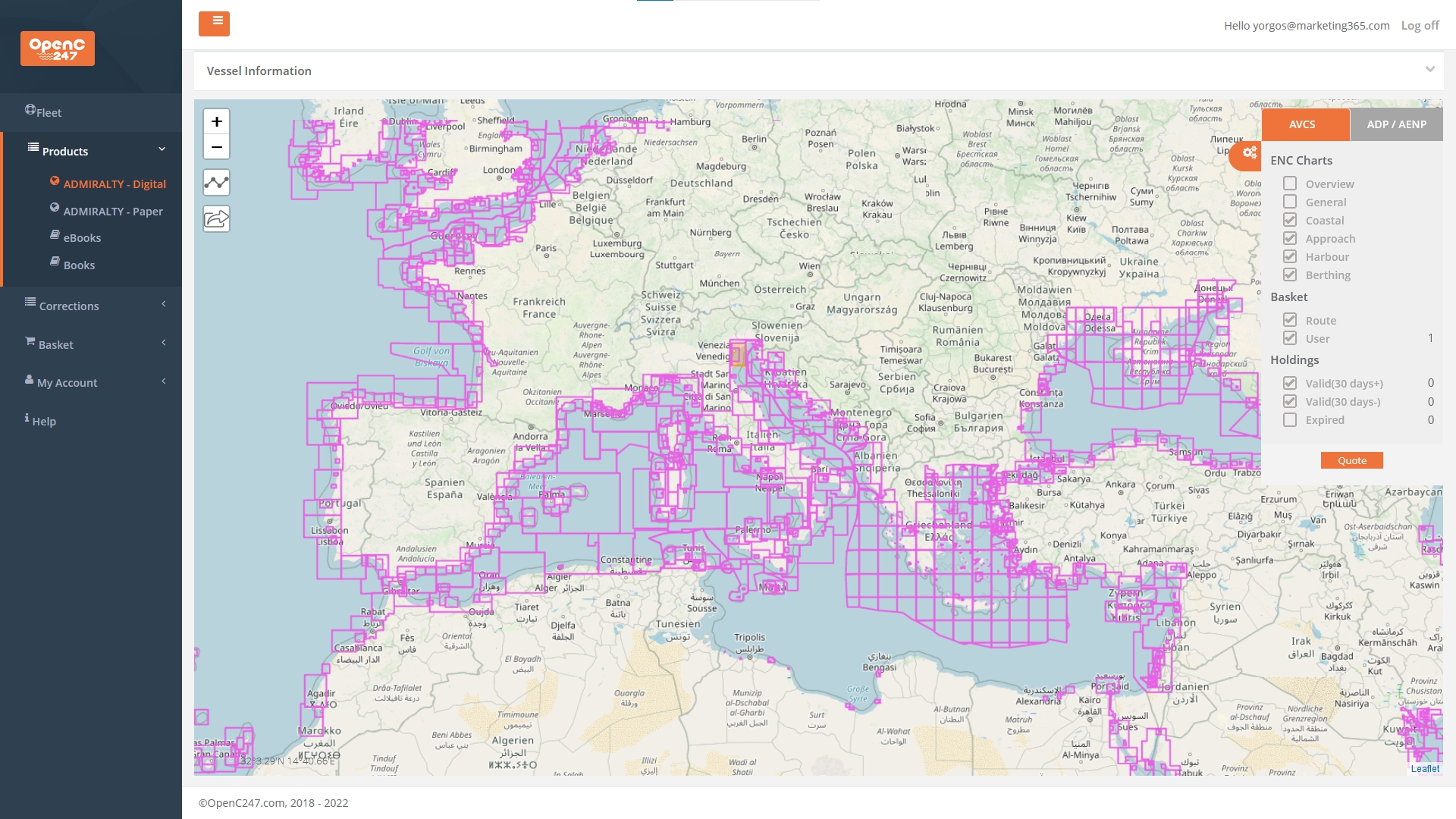
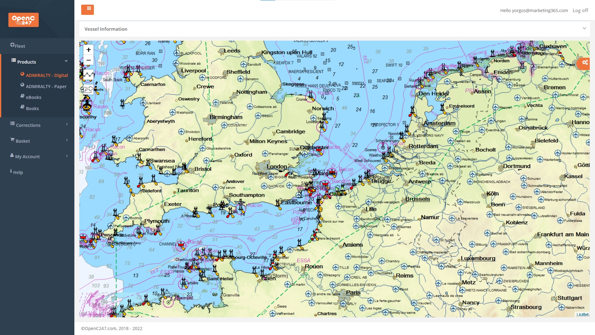
OpenC247 marine charts are available online 365/24/7 on any device (mobile / tablet / desktop). A fresh concept in access to Digital Charts and Paper Charts and Publications for your bridge passage planning tasks. Perfect for every captain of a leisure or commercial ship, any vessel – from a super yacht to a super tanker. You can get immediate access to what you need without subscription or hassle. Remain compliant, save time, save money. Simply register (Registration is FREE - No Subscription / No Recuring Fees), try the FREE service, see transparent pricing and pay online only for the nautical charts you use. Plus, compiled charts corrections and updates are completely free.
Riviera Charts maintains a substantial stock of official paper charts published by British ADMIRALTY and French SHOM. ADMIRALTY standard nautical charts comply with Safety of Life at Sea (SOLAS chapter V) regulations and are the de facto standard for commercial shipping, useful for passage planning, ocean crossings, coastal navigation and entering port. Paper and digital navigation and publication solutions. Riviera Charts also operates a print on demand service (POD). For leisure navigators, Riviera Charts also distributes ENC charts from suppliers including: Imray, Eagle Ray, SHOM, NV Charts
AMnautical (American Nautical Services) is a private company that has been in the industry for 45 years. AMnautical company currently specializes in the Maritime area (an ISO 9001 Certified Marine Surveying & Consulting firm and Nautical Chart Agent). Electronic navigational charts are one of the two key elements of electronic navigation. An ECDIS functions as the hardware, while an ENC contains the dataset of relevant information for a voyage. Together, these two components create a powerful digital navigation solution
Raymarine navigation displays give you the power to explore, plan, and navigate the open water, with confidence. High definition displays and quad-core performance brings electronic charts from leading map makers to life. Enjoy fully-featured vector charts, high-quality raster charts, plus advanced features like 3D maps, satellite overlays and automatic routing options. Raymarine LightHouse Charts offer superior visual presentation, combined with rich detail and accurate navigation from official hydrographic global sources. Available are a variety of chart styles, matched with color pallets. LightHouse Premium: unlocks data-rich points of interest (POI), high-res satellite aerial overlays by Mapbox, regular chart updates
The Electronic Chart Centre (ECC) was originally a maritime division of the Norwegian Mapping Authority (NMA). Electronic Chart Centre AS is Norwegian government enterprise created in 1999 to create and publish nautical charts for use by ships & boats. ECC is a centre of expertise for the collection, validation, distribution and visualisation of electronic charts and maps. Its vision is to contribute to greater safety and security, lower costs and enhanced efficiency at sea. Electronic navigational charts provide your ECDIS with the external, journey-specific data to function properly.
TIMEZERO offers one of the most complete and accurate marine chart data. Through MapMedia, a subsidiary specialized in digital cartography and Raster data treatment, TIMEZERO offers more than 6.000 nautical charts from around the world, including Vector charts (included are Vector Nautical Charts from C-Map Data). Raster vs Vector - High Resolution Satellite Photos - High Resolution Tidal Currents - Sedimentary Charts - Worldwide Charts Pack. Whether you are a professional or a passionate sailor, whatever your navigation type and your activity, your navigation area and your destination, you can display the specific chart data you need with your marine navigation software
Bundesamt für Seeschifffahrt und Hydrographie (BSH) - Germany. The German Federal Maritime and Hydrographic Agency is a higher federal authority coming under the jurisdiction of the Federal Ministry for Digital & Transport. BSH produces electronic navigational charts (ENCs) for its area of responsibility: the German territorial sea up to the border of the Exclusive Economic Zone, the Baltic Sea, and parts of the Southern Ocean. The ENCs contain all nautical chart information required for safe navigation. In addition, these digital charts contain supplementary information not found in the paper chart (eg: instructions for navigation)
ADMIRALTY comprehensive, official electronic & paper chart coverage of the world's commercial shipping routes & ports, an extensive range of planning charts to support passage planning tasks. Offrs among the world's most comprehensive official maritime chart coverage. UK Hydrographic Office (UKHO) is a world-leading hydrography centre, specialising in marine geospatial data. - ADMIRALTY Vector Chart Services (the world's most chosen ENC service for ECDIS) - ADMIRALTY Raster Chart Service (Electronic raster chart coverage of international shipping routes) - ADMIRALTY ECDIS & ENC Reference Publications (Practical guidance to support the use and implementation of ECDIS & ENCs) - AVCS & ARCS Updates & Support
French Naval Hydrographic and Oceanographic Service (SHOM). SHOM performs general hydrography duties for all seafarers to meet France’s international obligations under the international SOLAS Convention for the Safety of Life at Sea and the United Nations convention on the Law of the Sea. SHOM collects, archives produces and distributes official information necessary for maritime navigation. Shom produces the nautical charts & nautical works necessary to ensure the safety of navigation in French maritime areas as well as the areas under the cartographic responsibility of France. Shom has a catalog of mainly electronic nautical charts (and paper formats): nautical instructions, light books, navigator's guides. Shom's electronic charts (ENC) are distributed by PRIMAR regional coordination center.
Wärtsilä Nautical Chart Collection: developed by Wärtsilä Voyage in partnership with the United Kingdom Hydrographic Office (UKHO), the service delivers global marine chart coverage with a range of carefully considered additional data services. Get all nautical charts, maritime publications and services directly into your ECDIS and customised specifically to your needs. With remote maintenance, updates, issue detection and troubleshooting avoid costly on‑site visits and related costs.
Novaco charts offers up-to-date digital nautical charts. Access all the catalogues of charts and marine publications published by the Admiralty, other hydrographic offices and public or private organisations. Catalogues are updated weekly and help identify new editions as they emerge.
Novaco’s Instant Permit Service (IPS) provides new permit files to unlock ADMIRALTY AVCS, ADP and AeNP products instantly.
GARMIN (through its subsidiary, Navionics) creates marine navigation charts for GPS chartplotters and mobile devices, on GPS plotter or mobile, view seabed or lake bottom from multiple perspectives. Navionics charts are electronic charts providing 3D, hydrographic data for ship captains, mariners and government agencies. Offers global coverage of all waterways, charts can be customized to enhance water bottom and depth details using proprietary bathymetry charts. Via boating apps charts are available for Canada, USA, Pacific Islands, Africa, Asia and Brazil to the Caribbean too
PRIMAR marine navigational charts is an international cooperation for the provision of a consistent and reliable Electronic Navigational Chart (ENC) service. It is a worldwide ENC service operated by the Norwegian Hydrographic Service on a non-profit basis to deliver official electronic navigational charts (ENC) for use in ECDIS & ECS. Primar's ENCs meet SOLAS charts and carriage requirements. Updates are provided online or on CD Rom. PRIMAR Portal Chart Catalogues: Web based online order tool for marine charts and services (PRIMAR Portal)
C-Map offers the most personal, stress-free, end to end marine experience by providing high-quality digital nautical maps along with navigation, traffic and weather information to easily plan marine trips. C-MAP charts offer detailed coverage in multiple formats for lakes, coasts and oceans to help you navigate wherever you are in the world. C-MAP digital charts are loaded with precision data from multiple sources, frequently updated
NV Charts nautical charts are remarkably detailed nautical charts of high quality in paper, digital electronic nautical charts on pc/tablet, andoid, apple ios. Practical and easy to use, NV Charts are the first marine charts of their kind that are easy to view, are more robust than traditional paper nautical charts, and which can be used in conjunction with the handy NV Charts App which is a great tool to help you navigate on mobile devices with NV charts marine boating cartography
Nautical charts, publications and survey results from the Canadian Hydrographic Service. Purchase digital marine charts for navigational use or download sample charts in a variety of formats. Canadian Hydrographic Service offers a wide range of nautical publications that are indispensable companions to charts, enhancing safety at sea
Japan Hydrographic Association (Japan Hydrographic Office), a public corporation distributing marine charts, nautical publications, marine data, and does R&D maritime rleated activities. Visit Japan's Nautical Chart Web Shop, search for Japanese Charts by main ports and routes to get your Electronic Navigational Charts(ENC) or Paper Charts and Maritime Publications online
ChartWorld marine charts shop offers more than 50.000 different electronic marine charts and chart products in different formats. In order to conveniently select the correct and most suitable charts for your voyage, you can use the Graphical Chart Selection Tool or select your chart product from the menu online
OpenSeaMap - the free digital nautical charts. OpenSeaMap is a software project collecting freely usable nautical information and geospatial data to create a worldwide nautical chart. A worldwide open-source project for visualisation of a free nautical database using OpenStreetMap data. The OpenSeaMap chart is available on the OpenSeaMap website, and can also be downloaded for use as an electronic navigational chart for offline applications
Danish Nautical charts by DHO - Danish Hydrographic Office. The nautical chart catalog of the Danish Hydrographic Office offers a very complete selection of Greenland nautical charts that comply with SOLAS regulations (Safety of Life at Sea) and are perfectly suitable for professional, commercial or leisure use
i-Boating: Free Marine Navigation Charts & Fishing Maps - this online marine chart viewer (charts included) requires javascript. Once enabled you can view lake depth contour maps, electronic navigation charts (ENCs) in your browser. Is the first marine navigation app to offer vector marine charts & lake maps on iOS, Android, Windows, MacOS BB & free web nautical app
Sources and publication of Nautical Charts
A nautical chart is a graphic representation of a sea area and adjacent coastal regions. Depending on the scale of the chart, it may show depths of water and heights of land (topographic map), natural features of the seabed, details of the coastline, navigational hazards, locations of natural and human-made aids to navigation, information on tides and currents, local details of the Earth's magnetic field, and human-made structures such as harbours, buildings, and bridges. Nautical charts are essential tools for marine navigation; many countries require vessels, especially commercial ships, to carry them. Nautical charting may take the form of charts printed on paper (raster navigational charts) or computerized electronic navigational charts (ENCs). Recent technologies have made available paper charts which are printed "on demand" with cartographic data that has been downloaded to the commercial printing company as recently as the night before printing. With each daily download, critical data such as Local Notices to Mariners are added to the on-demand chart files so that these charts are up to date at the time of printing.
Nautical charts are based on hydrographic surveys. As surveying is laborious and time-consuming, hydrographic data for many areas of sea may be dated and are sometimes unreliable. Depths are measured in a variety of ways. Historically the sounding line was used. In modern times, echo sounding is used for measuring the seabed in the open sea. When measuring the safe depth of water over an entire obstruction, such as a shipwreck, the minimum depth is checked by sweeping the area with a length of horizontal wire. This ensures that difficult to find projections, such as masts, do not present a danger to vessels navigating over the obstruction.
Nautical charts are issued by power of the National Hydrographic Offices in many countries. These charts are considered "official" in contrast to those made by commercial publishers. Many hydrographic offices provide regular, sometimes weekly, manual updates of their charts through their sales agents. Individual hydrographic offices produce national chart series and international chart series. Coordinated by the International Hydrographic Organization, the international chart series is a worldwide system of charts ("INT" chart series), which is being developed with the goal of unifying as many chart systems as possible.
There are also commercially published charts, some of which may carry additional information of particular interest, e.g. for yacht skippers. (SOURCE: wikipedia - NAUTICAL CHARTS)
FEATURED Digital Nautical Charts provider - OPENC247
buy nautical charts online - No Subscription / No Recuring Fees - pay online only for the nautical charts you use
OPENC247 - the smarter way to sail! PAPER & DIGITAL & NAUTICAL CHARTS
Nautical Charts, Charts Corrections and Marine Publications
No Subscription. No Commitment. Complete Flexibility - 24/7
INSTANT PERMITS
FREE CORRECTIONS & UPDATES
NO SUBSCRIPTIONS !
AVAILABLE ONLINE 365/24/7 ON ANY DEVICE (mobile / tablet / desktop)
A fresh concept in access to Digital Charts and Paper Charts and Publications for your bridge. Perfect for every captain of a leisure or commercial ship, any vessel – from a super yacht to a super tanker
You can get immediate access to what you need without subscription or hassle. Remain compliant, save time, save money.
Simply register (Registration is FREE - No Subscription / No Recuring Fees), try the FREE service, see transparent pricing and pay online only for the nautical charts you use. Plus, compiled charts corrections and updates are completely free.
In addition to the ECDIS equipments used by large ocean-going vessels, ENCs (Electronic Navigation Charts) can also be used in a growing variety of electronic chart systems (ECS), chart plotters, and mobile devices by professional mariners and leisure craft owners alike
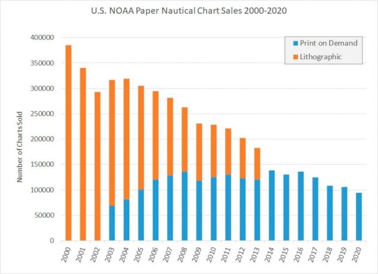
While the use of Digital Nautical Charts (ENCs) is increasing - use of Paper Nautical Charts is in dramatic decline...
ENC data is produced by many countries and used by mariners around the world. In addition to the ECDIS equipment used by large ocean-going vessels, ENCs can also be used in a growing variety of electronic chart systems (ECS), chart plotters, and mobile devices by professional mariners and leisure craft owners alike.
Use of ENCs also enables real-time vessel positioning and automated alarms or indications of unsafe conditions during voyage planning and while underway – safety features that paper charts cannot provide. The IHO has developed a new “S-101 ENC”7 that will eventually replace the “S-57 ENC” data currently used for navigation. The new ENC product specification enables interoperability with a growing family of maritime related products that comply with the IHO’s S-100 Universal Hydrographic Data Model. As hydrographic offices, including NOAA, start to produce S-101 format ENCs in the coming years, some systems will likely use the ENC as a “base map” over which other S-100 based products, such as marine protected areas, navigational warnings, surface currents, and other types of data, might be displayed. These are clear indications that ENCs are already an important part of the marine navigation “ecosystem” and will be even more so in the future.
Whilst ENC (electronic nautical charts) use is increasing, the use of traditional paper nautical charts is decreasing. Sales of NOAA paper nautical charts have dropped nearly 60% since 2010, sustaining a downward trend that started over two decades ago (see Figures below). The IHO Nautical Cartography Working Group documented similar declining sales of paper charts published by many other hydrographic offices around the world in their “Future of the Paper Nautical Chart Final Report”, released in August 2020.
(Stats figures by N.O.A.A.) - NOAA has distributed paper nautical charts exclusively through commercial print -on-demand partners since 2014. Sales of both lithographic and print-on-demand paper charts have been declining for over two decades as the sales stats above demonstrate. Guided by these trends, NOAA initiated a program to phase out its traditional paper nautical charts and their corresponding raster chart products and services
(source: International Hydrographic Organization (IHO) - https://ihr.iho.int/articles/the-end-of-traditional-paper-charts-the-final-transition-to-electronic-navigational-charts/ )
list of the best marine electronic chart solutions, digital vector and raster maritime navigation charts for your passage planning, from commercial ships to leisure vessels
list of the best printed marine chart providers & paper nautical charts sales agents worldwide for all needs: voyage planning for commercial fleets, leisure ships, yachts, superyachts
selection of nautical charts corrections & updates solutions from premium providers across the globe. A critical service for safe passage planning everywhere in the sea world
directory list of selected premium Nautical Publications, paper and digital marine publications from the best providers worldwide to help mariners with day to day passage plan
We use cookies on our website to give you the most relevant experience by remembering your preferences and repeat visits. By clicking “Accept All”, you consent to the use of ALL the cookies. However, you may visit "Cookie Settings" to provide a controlled consent.
This website uses cookies to improve your experience while you navigate through the website. Out of these, the cookies that are categorized as necessary are stored on your browser as they are essential for the working of basic functionalities of the website. We also use third-party cookies that help us analyze and understand how you use this website. These cookies will be stored in your browser only with your consent. You also have the option to opt-out of these cookies. But opting out of some of these cookies may affect your browsing experience.
Necessary cookies are absolutely essential for the website to function properly. These cookies ensure basic functionalities and security features of the website, anonymously.
Cookie
Duration
Description
cookielawinfo-checkbox-analytics
11 months
This cookie is set by GDPR Cookie Consent plugin. The cookie is used to store the user consent for the cookies in the category "Analytics".
cookielawinfo-checkbox-functional
11 months
The cookie is set by GDPR cookie consent to record the user consent for the cookies in the category "Functional".
cookielawinfo-checkbox-necessary
11 months
This cookie is set by GDPR Cookie Consent plugin. The cookies is used to store the user consent for the cookies in the category "Necessary".
cookielawinfo-checkbox-others
11 months
This cookie is set by GDPR Cookie Consent plugin. The cookie is used to store the user consent for the cookies in the category "Other.
cookielawinfo-checkbox-performance
11 months
This cookie is set by GDPR Cookie Consent plugin. The cookie is used to store the user consent for the cookies in the category "Performance".
viewed_cookie_policy
11 months
The cookie is set by the GDPR Cookie Consent plugin and is used to store whether or not user has consented to the use of cookies. It does not store any personal data.
Functional cookies help to perform certain functionalities like sharing the content of the website on social media platforms, collect feedbacks, and other third-party features.
Performance cookies are used to understand and analyze the key performance indexes of the website which helps in delivering a better user experience for the visitors.
Analytical cookies are used to understand how visitors interact with the website. These cookies help provide information on metrics the number of visitors, bounce rate, traffic source, etc.
Advertisement cookies are used to provide visitors with relevant ads and marketing campaigns. These cookies track visitors across websites and collect information to provide customized ads.