Testing Sep 2025
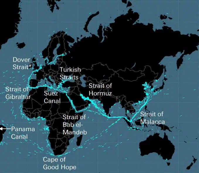
کابل ها، خطوط لوله، جاده ها، تنگه های دریایی، مسیرهای هوایی و ماهواره ها شبکه شکننده ای را تشکیل می دهند که اقتصاد جهانی بر روی آن ساخته شده است. اینها شبکههای نامرئی هستند که اهمیت زیادی برای زنجیره تأمین جهانی و زندگی مدرن دارند، اما تنها زمانی به یاد میآیند که جنگی مانند اوکراین یا اسرائیل یکی از این استراتژیکهای استراتژیک را تهدید کند.
DEEPSEA: نسل بعدی بهینه سازی سفر با استفاده از هوش مصنوعی (AI) از مسیریابی عملکرد هوش مصنوعی (AI) استفاده کنید تا فوراً مسیر کربن زدایی ناوگان خود را تسریع کنید و هزینه سوخت را کاهش دهید. مسیریابی عملکرد تأثیر عمده و قابل سنجشی بر مصرف سوخت ناوگان و CII امروز شما خواهد گذاشت، نتایج پر تأثیر از روز اول. راه حل هوش مصنوعی بهینه سازی سفر کشتی های عمیق باعث کاهش انتشار گازهای گلخانه ای می شود، […]
World's most famous Luxurious Marinas: Which are the most luxurious and popular marinas worldwide? Portofino, Monaco, St. Tropez, Ibiza, St. Barts. One of the first images that comes to mind when we think of these places are their iconic marinas. Dignitaries, powerful people of wealth, glamorous Hollywood stars and all those who have made yachting […]
Fishing is changing for the good of the Earth - advanced bio-based plastic solutions (By Tassoula Eptakili - www.kathimerini.gr) Almost 12 million tons of plastic waste end up in the world's oceans every year. Sometimes they travel in the water, creating huge underwater garbage dumps, and sometimes they come ashore. The effects of mindless consumption […]
Google - Data Centers Through 2022, Google has strengthened its commitment in Greece to accelerate sustainable and inclusive development and digital transformation, further intensifying its substantial support to the country. With strategic initiatives, and with a focus on people, the technology company opened a new important chapter in Greece with the announcement of the creation […]
صد نفر از لیست لویدز، رتبه بندی نفوذ و قدرت در کشتیرانی، حتی با کاهش قدرت مالکان کشتی، اقدامات فردی همچنان در کشتیرانی اهمیت دارد. با این حال، لحظه تعیین کننده امسال از سوی اتحادیه اروپا آمده است، که با انجام اقدامات ملموس برای مقابله با تغییرات اقلیمی فناوری اطلاعات، IMO را به عنوان تأثیرگذارترین نیرو در صنعت پشت سر گذاشته است.
UKHO announced intention to end Paper Nautical Chart production (26 July 2022) (source: UK Hydrographic Office) The UK Hydrographic Office (UKHO) has announced on 26 July 2022 its intention to develop options for the withdrawal from global paper nautical chart production by late 2026 to increase focus on its digital navigation products and services. ("UKHO […]
از زمانی که مردم شروع به ساختن چیزهای پیچیده کردند، متوجه شدند که نیاز به یک سیستم اندازه گیری وجود دارد. در اصل اساس بدن انسان بود. فرانسه انقلابی قرار بود چیزی را تولید کند که به سیستم قطعی بینالمللی واحدها (سیستم اندازهگیری بینالمللی) تبدیل شد.
اسطوره Aegean متعلق به Arcadia Shipmanagement توسط DNV به عنوان اولین کشتی تایید شده SEEMP III جامعه طبقه بندی کشتی DNV به Arcadia Shipmanagement Co Ltd گواهینامه ای ارائه کرد که کشتی خود را Egean Myth به عنوان اولین کشتی در سراسر جهان که دارای راهنمای SEEMP III است به رسمیت می شناسد. طرح شدت کربن عملیاتی کشتی یا SEEMP قسمت III، بخشی از […]
از آگوست 2022، دلفین های پرنده هلنیک سی وییز که ده ها، اگر نگوییم صدها میلیون مسافر یونانی و خارجی را در خلیج آرگوسارونیکو در پنج دهه گذشته حمل کردند، در تاریخ ثبت خواهند شد. در تصور بیشتر آنها به عنوان وسایل نقلیه پر سر و صدا اما سریع برای تابستان و نه تنها فرار، عمدتاً در آرگوسارونیکو، […]
(Marine Shipping Glossary terms are offered by Hellenic Shipping News) press CTRL + F in your web browser to pop up the Search Bar and type the term you want to find... Maritime Dictionary app in Google Play Maritime Dictionary App Marine (app) in google Play Shipping Dictionary (app) in Google Play Naval Terms Dictionary […]
اصلاحات و به روز رسانی های نمودار نمودارهای دریایی قدیمی و غیر به روز (حتی از چند هفته) هرگز نباید برای ناوبری دریایی و برنامه ریزی سفر استفاده شوند. ویژگیهای یک رودخانه، بهویژه، که در نمودار دریایی به تصویر کشیده میشود، به طور مداوم تغییر میکند و کمکهای ناوبری مصنوعی در دریا یا سواحل ممکن است در هر زمان تغییر کنند. به عنوان یک […]
NOAA's Nautical Paper Charts (Raster Nautical Charts: both paper and digital Raster Charts) will soon not be produced any more (by 2025) On April 13, the US federal government's National Oceanic & Atmospheric Administration (NOAA) announced it will soon stop printing traditional lithographic (paper) nautical charts - while other forms of nautical charts, such as […]
خدمات نقشه وب (مقایسه) محبوبترین خدمات نقشه وب Google Maps Bing Maps MapQuest OpenStreetMap Here WeGo Apple Maps Yandex Maps فهرست مقایسه ویژگی نقشههای گوگل نقشههای بینگ MapQuest OpenStreetMap در اینجا WeGo نقشههای اپل نقشههای Yandex مجوز اختصاصی اختصاصی ویژگی اختصاصی کامل استرالیا، کانادا، چین، فرانسه، آلمان، اسرائیل، ایتالیا، […]
A catalog of free (not necessarily Open Source) Satellite Navigation (or "GPS") software for a wide range of devices. (Navigation software with free maps - often uses maps from OpenStreetMap project) Satellite Navigation Software- Non-free maps Name Company Type of device[5] Operating system 3rd-party GPS-able?[6] Software with maps? Follows streets? Open-source? Remarks Aqua Map[29] GEC […]
اختصارات مورد استفاده در نمودارهای دریایی چیست (نمودار دریاسالاری / نمودارهای دریایی) مشخصات پایین و اختصارات اسم ها منبع نمودار اسم مخفف Boulders Blds Blds Clay Cl Cy Coral Co Co Coralhead Cl Hd Cl Hd Gravel GG Grass Grs Grs Mud […]
Filipinos: major source of Seafarers for the global maritime sector - One third of the world's seafarers are Filipinos. In the 1970s, the number of seafarers in traditional maritime countries dropped, resulting in a transfer of supply to countries such as India, China, and the Philippines. The Philippines has developed to become a significant producer […]
یک پورتال جدید پیچیده برای نمودارها و نشریات دریایی راه اندازی شده است که بدون اشتراک یا حداقل مدت قرارداد و به روز رسانی و اصلاحات رایگان است. OpenC247.com به تقاضای فزاینده برای فناوری های دیجیتال در بخش دریایی پاسخ می دهد. راه اندازی نرم این پورتال بیش از 150 کاربر ثبت نام شده را از کاپیتان های فوق العاده جذب کرده است.
European Digital Twin of the Ocean (European DTO) This tool will model the ocean and provide knowledge and understanding of the past and present and will create credible predictions of the ocean's future health. The ILIAD consortium will develop virtual representations of the sea that will integrate earth observing, modelling and digital infrastructures to provide […]
What is the Differences between VECTOR and RASTER Graphics? (right below its treated the difference Raster/Vector in regards to graphics - look further below for the difference between Vector Nautical Charts (VNC) and Raster Nautical Charts (RNC)) There is some confusion to many people when it comes to the differences between vector and raster graphics. […]
(* source: www.sailingissues.com - by Diederik Willemsen) Marine Navigation courses (FREE) Find advanced online course on marine navigation for offshore sailing. All though nowadays most sailors rely on maritime navigation and positioning equipment like the use of GPS / Galileo / GLONASS and Radars to navigate, by navigating by yourself is a lot more fun, Learn navigation to sail […]
(* source: NOAA - the National Oceanic and Atmospheric Administration (USA), the American scientific and regulatory agency - Symbols, Abbreviations and Terms used on Paper and Electronic Nautical Charts ENCs) Paper and Electronic Navigational Charts: Symbols, Abbreviations and Terms used on Marine Navigation Charts see a full list of symbols used on paper nautical charts […]
GLOSSARY of Nautical Charts, terms & abbreviations used in the maritime industry (* source: NOAA - the National Oceanic and Atmospheric Administration (USA), the American scientific and regulatory agency) An authoritative source for terms used in cartography (mapping), marine charting, and geodesy used in the nautical charting program. Terms and definitions are of specific cartographic […]
همه ارائه دهندگان برتر محصولات و خدمات ناوبری دریایی را برای برنامه ریزی سفر دریایی ایمن پیدا کنید