Testing Sep 2025
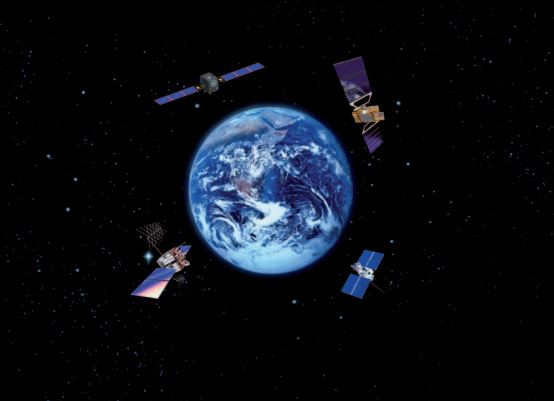
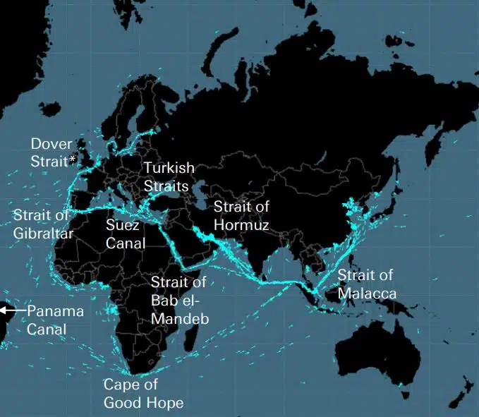
Cavi, condutture, strade, stretti marittimi, rotte aeree e satelliti costituiscono la fragile rete su cui è costruita l’economia globale. Si tratta di reti invisibili di enorme importanza per la catena di fornitura globale e per la vita moderna, che però vengono ricordate solo quando una guerra come quella in Ucraina o Israele minaccia uno di questi […]
DEEPSEA: ottimizzazione del viaggio di nuova generazione alimentata dall'Intelligenza Artificiale (AI) Utilizza Performance Routing dell'Intelligenza Artificiale (AI) per accelerare istantaneamente la traiettoria di decarbonizzazione della tua flotta e ridurre i costi del carburante. Performance Routing avrà oggi un impatto importante e quantificabile sul consumo di carburante e sul CII della tua flotta, risultati ad alto impatto sin dal primo giorno. “La soluzione AI per l'ottimizzazione del viaggio in nave in acque profonde riduce le emissioni, […]
World's most famous Luxurious Marinas: Which are the most luxurious and popular marinas worldwide? Portofino, Monaco, St. Tropez, Ibiza, St. Barts. One of the first images that comes to mind when we think of these places are their iconic marinas. Dignitaries, powerful people of wealth, glamorous Hollywood stars and all those who have made yachting […]
Fishing is changing for the good of the Earth - advanced bio-based plastic solutions (By Tassoula Eptakili - www.kathimerini.gr) Almost 12 million tons of plastic waste end up in the world's oceans every year. Sometimes they travel in the water, creating huge underwater garbage dumps, and sometimes they come ashore. The effects of mindless consumption […]
Google - Data Centers Through 2022, Google has strengthened its commitment in Greece to accelerate sustainable and inclusive development and digital transformation, further intensifying its substantial support to the country. With strategic initiatives, and with a focus on people, the technology company opened a new important chapter in Greece with the announcement of the creation […]
Lloyd's List's One Hundred People, classifica dell'influenza e del potere all'interno della navigazione Le azioni individuali contano ancora nella navigazione, anche se il potere degli armatori sta diminuendo. Eppure il momento decisivo di quest'anno è arrivato dall'UE, che ha superato l'IMO come forza più influente nel settore, intraprendendo azioni tangibili per affrontare il cambiamento climatico […]
UKHO announced intention to end Paper Nautical Chart production (26 July 2022) (source: UK Hydrographic Office) The UK Hydrographic Office (UKHO) has announced on 26 July 2022 its intention to develop options for the withdrawal from global paper nautical chart production by late 2026 to increase focus on its digital navigation products and services. ("UKHO […]
Da quando le persone hanno iniziato a costruire cose complicate, si sono rese conto che era necessario un sistema di misurazione. Originariamente la base era il corpo umano. La Francia rivoluzionaria doveva produrre ciò che si è evoluto nel definitivo Sistema Internazionale di Unità (Sistema Internazionale di Misurazione) Gli Egiziani usavano cubiti che erano circa 52,4 centimetri, ma perché […]
L'Aegean Myth di Arcadia Shipmanagement è stata riconosciuta da DNV come la prima nave SEEMP III verificata La società di classificazione DNV ha presentato ad Arcadia Shipmanagement Co Ltd un certificato che riconosce la propria nave Aegean Myth come la prima nave al mondo ad avere un manuale SEEMP III. Il piano operativo di intensità di carbonio della nave o SEEMP parte III, fa parte di […]
Dall'agosto 2022, i delfini volanti di Hellenic Seaways, che negli ultimi cinquant'anni hanno trasportato decine, se non centinaia di milioni di passeggeri greci e stranieri nel Golfo di Argosaronico, passeranno alla storia. Associato nella percezione della maggior parte dei veicoli rumorosi ma veloci per fughe estive e non solo, principalmente ad Argosaronicos, […]
(Marine Shipping Glossary terms are offered by Hellenic Shipping News) press CTRL + F in your web browser to pop up the Search Bar and type the term you want to find... Maritime Dictionary app in Google Play Maritime Dictionary App Marine (app) in google Play Shipping Dictionary (app) in Google Play Naval Terms Dictionary […]
Correzioni e aggiornamenti delle carte Carte nautiche vecchie, non aggiornate (anche da poche settimane) non dovrebbero mai essere utilizzate per la navigazione marittima e la pianificazione del viaggio. Le caratteristiche di un fiume, in particolare, raffigurate su una carta nautica tendono a cambiare continuamente e gli aiuti artificiali alla navigazione in mare o in riva possono essere modificati in qualsiasi momento. Come un […]
NOAA's Nautical Paper Charts (Raster Nautical Charts: both paper and digital Raster Charts) will soon not be produced any more (by 2025) On April 13, the US federal government's National Oceanic & Atmospheric Administration (NOAA) announced it will soon stop printing traditional lithographic (paper) nautical charts - while other forms of nautical charts, such as […]
Servizi Web Map (confronto) Servizi Web Map più popolari Google Maps Bing Maps MapQuest OpenStreetMap Here WeGo Mappe Apple Mappe Yandex Elenco di confronto Funzionalità Google Maps Mappe Bing MapQuest OpenStreetMap Here WeGo Mappe Apple Mappe Yandex Licenza Proprietario Proprietario Proprietario ODbL Proprietario Proprietario Disponibilità Pieno funzionalità extra Australia, Canada, Cina, Francia, Germania, Israele, Italia, […]
A catalog of free (not necessarily Open Source) Satellite Navigation (or "GPS") software for a wide range of devices. (Navigation software with free maps - often uses maps from OpenStreetMap project) Satellite Navigation Software- Non-free maps Name Company Type of device[5] Operating system 3rd-party GPS-able?[6] Software with maps? Follows streets? Open-source? Remarks Aqua Map[29] GEC […]
quali sono le abbreviazioni usate nelle Carte Nautiche (Carte dell'Ammiragliato / Carte Marittime) Caratteristiche e abbreviazioni del fondale Nomi Fonte Grafico Abbreviazione Abbreviazione Boulders Blds Blds Clay Cl Cy Coral Co Co Coralhead Cl Hd Cl Hd Gravel GG Grass Grs Grs Mud MM […]
Filipinos: major source of Seafarers for the global maritime sector - One third of the world's seafarers are Filipinos. In the 1970s, the number of seafarers in traditional maritime countries dropped, resulting in a transfer of supply to countries such as India, China, and the Philippines. The Philippines has developed to become a significant producer […]
E' stato lanciato un nuovo sofisticato portale di carte e pubblicazioni nautiche che non prevede abbonamento o durata minima contrattuale, aggiornamenti e correzioni gratuiti. OpenC247.com risponde alla crescente domanda di tecnologie digitali nel settore marittimo. Il soft launch del portale ha attirato più di 150 utenti registrati, da capitani di super […]
European Digital Twin of the Ocean (European DTO) This tool will model the ocean and provide knowledge and understanding of the past and present and will create credible predictions of the ocean's future health. The ILIAD consortium will develop virtual representations of the sea that will integrate earth observing, modelling and digital infrastructures to provide […]
What is the Differences between VECTOR and RASTER Graphics? (right below its treated the difference Raster/Vector in regards to graphics - look further below for the difference between Vector Nautical Charts (VNC) and Raster Nautical Charts (RNC)) There is some confusion to many people when it comes to the differences between vector and raster graphics. […]
(* source: www.sailingissues.com - by Diederik Willemsen) Marine Navigation courses (FREE) Find advanced online course on marine navigation for offshore sailing. All though nowadays most sailors rely on maritime navigation and positioning equipment like the use of GPS / Galileo / GLONASS and Radars to navigate, by navigating by yourself is a lot more fun, Learn navigation to sail […]
(* source: NOAA - the National Oceanic and Atmospheric Administration (USA), the American scientific and regulatory agency - Symbols, Abbreviations and Terms used on Paper and Electronic Nautical Charts ENCs) Paper and Electronic Navigational Charts: Symbols, Abbreviations and Terms used on Marine Navigation Charts see a full list of symbols used on paper nautical charts […]
GLOSSARY of Nautical Charts, terms & abbreviations used in the maritime industry (* source: NOAA - the National Oceanic and Atmospheric Administration (USA), the American scientific and regulatory agency) An authoritative source for terms used in cartography (mapping), marine charting, and geodesy used in the nautical charting program. Terms and definitions are of specific cartographic […]
Trova tutti i principali fornitori di prodotti e servizi di navigazione marittima per una pianificazione sicura del viaggio marittimo