کابل ها، خطوط لوله، جاده ها، تنگه های دریایی، مسیرهای هوایی و ماهواره ها شبکه شکننده ای را تشکیل می دهند که اقتصاد جهانی بر روی آن ساخته شده است. اینها شبکه های نامرئی هستند که اهمیت زیادی برای زنجیره تامین جهانی و زندگی مدرن دارند، اما تنها زمانی به یاد می آیند که جنگی مانند اوکراین یا اسرائیل یکی از این نقاط استراتژیک را تهدید کند. مطالعه دویچه بانک پنج حلقه ضعیف اقتصاد جهانی را روشن می کند. یعنی زیرساخت هایی که با جایگزینی جایگزین نمی شوند و بنابراین می توانند زنجیره تامین جهانی را مسدود کنند.
آسیب پذیری هایی در اقتصاد جهانی وجود دارد که کم و بیش برای همه شناخته شده است، مانند کارخانه های نیمه هادی تایوان، مراکز مالی جهانی و 0.5% ایستگاه های مترو در لندن و پاریس که می تواند نیمی از شبکه را مسدود کند.
اما شبکههای نامرئی اما بسیار مهمی نیز وجود دارند، همانطور که با آسیب وارد شده به خط لوله گاز زیردریایی و کابل مخابراتی بین فنلاند و استونی در 10 اکتبر نشان داد که یادآور خرابکاری خط لوله نورد استریم یک سال پیش است. دویچه بانک خاطرنشان می کند که در سال 2010، فوران یک آتشفشان در ایسلند یک ثانیه از ترافیک هوایی اروپا را به مدت 8 روز متوقف کرد.
هم اوکراین و هم اسرائیل در نزدیکی چنین نقاط مهمی برای اقتصاد جهانی قرار دارند.
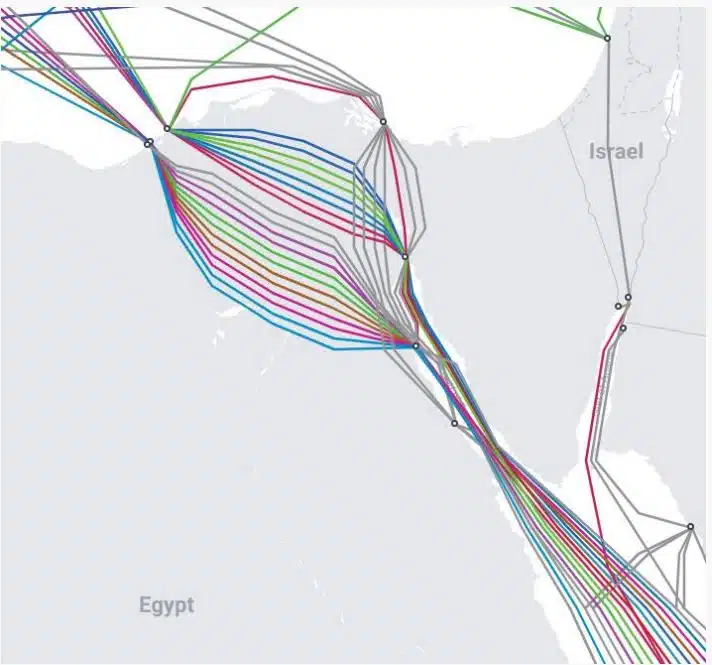
– کابل های داده: تا 99% از ارتباطات دیجیتال جهان و همچنین 10 تریلیون تراکنش مالی. دلار، از طریق کابل های فیبر نوری واقع در کف دریا عبور کنید. تقریباً 550 کابل فعال و برنامه ریزی شده وجود دارد که 1.4 میلیون کیلومتر را پوشش می دهد. دویچه بانک توضیح می دهد که بسیاری از آنها به سختی ضخیم تر از یک قوطی آبیاری هستند. این کابل ها در برابر جاسوسی و خرابکاری و آسیب های تصادفی آسیب پذیر هستند.

– کابل های برق زیر دریا: اتصالات برق به کشورها این امکان را می دهد که با آب و هوای مطلوب تر، افزایش امنیت عرضه و مدیریت بهتر تقاضا، برق بادی یا خورشیدی ارزان تری از همسایگان خود خریداری کنند. اما، آنها می توانند با خرابکاری یا تصادف از بین بروند.
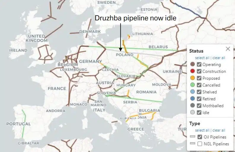
– خطوط لوله گاز طبیعی: اروپا برای تامین بیشتر گاز طبیعی خود به خطوط لوله وابسته است. در سال 2020 تقریباً 401 TP3 تن از گاز طبیعی خود را از روسیه وارد کرد و از آن زمان به بعد مجبور شد به خطوط لوله از نروژ متکی باشد و LNG وارد کند. همانطور که انفجارهای نورد استریم نشان داد، این خطوط لوله در برابر خرابکاری آسیب پذیر هستند.

– خطوط لوله نفت: بیشتر خطوط لوله نفت جهان در اروپا و آسیا واقع شده و از روسیه شروع می شود. یک خط لوله معمولی نفت حدود 50 سانتی متر قطر دارد و می تواند بیش از 1 میلیون لیتر (یا 6.300 بشکه در ساعت) را حمل کند. در مقایسه، یک بشکه می تواند کمتر از 200 بشکه را در یک زمان حمل کند. خطوط لوله از فولاد ساخته شده و در صورت امکان در زمین مدفون می شوند. مانند خطوط لوله گاز طبیعی، در برابر آسیب، زلزله و خرابکاری آسیب پذیر هستند.
برخی از راهآهنها و جادهها در مکانهای دوردست، سهم نامتناسب زیادی از منابع حیاتی برای اقتصاد جهانی را بدون هیچ جایگزینی حمل میکنند. برای مثال، منطقه وسیعی در کنگو و زامبیا، بزرگترین تولیدکننده مس آفریقا است و دو سوم تولید کبالت جهان را به خود اختصاص داده است. اما برای انتقال این مواد خام از معادن به بنادر نامیبیا، آفریقای جنوبی، موزامبیک و تانزانیا، تنها چهار جاده وجود دارد که همگی بد و شلوغ هستند. چیزی مشابه در مورد سویای برزیل که صادرکننده شماره 1 جهان است، در حال وقوع است. در دو سال گذشته، خشکسالی رودخانههایی را که آبراههای حیاتی هستند، تحت تأثیر قرار داده است و نشان میدهد که این حملونقل چقدر آسیبپذیر است.
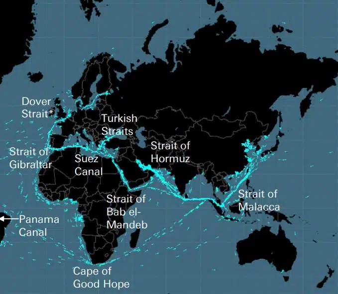
همراه با دماغه امید خوب، 8 تنگه مهم برای حمل و نقل دریایی وجود دارد. همانطور که دویچه بانک توضیح می دهد، اگر تنگه دوور برداشته شود و کانال پاناما، تنگه ترکیه، تنگه باب المادب و تنگه هرمز به آن اضافه شود، این پنج کلید برای امپراتوری بریتانیا باز شد. . به عنوان مثال، در نفت، بیش از 60% عرضه از طریق دریا حمل می شود که تنگه هرمز مهمترین نقطه برای بازار است، زیرا یک پنجم مصرف جهان (و یک سوم LNG) از آن عبور می کند. تنگه هرمز در باریک ترین نقطه خود تنها 33 کیلومتر عرض دارد.
این تنگه ها در برابر محاصره، برخورد کشتی ها یا زمینگیر شدن، دزدان دریایی، حملات تروریستی، جنگ ها و حوادثی مانند نشت نفت آسیب پذیر هستند.
حمل و نقل هوایی وابسته به شبکه نامرئی از راهروها است که می تواند توسط آب و هوا، جنگ یا رویدادهای غیرعادی مختل شود، مانند زمانی که حریم هوایی اسپانیا در نوامبر گذشته بسته شد تا یک موشک چینی بتواند وارد جو زمین شود. اعتصابهای کنترلکنندههای ترافیک هوایی امسال باعث ایجاد مشکلات عمده حملونقل در اروپا شده است، در حالی که بزرگترین محاصره ترافیک هوایی پس از جنگ در سال 2010 رخ داد، زمانی که آتشفشان در ایسلند فوران کرد.
جهان بسیار به سیستم موقعیت یاب جهانی ایالات متحده (GPS) وابسته است. این تقریباً از 30 ماهواره موقعیتیابی، ناوبری و زمانبندی (PNT) در مدار زمین استفاده میکند که سیگنالهایی را به بیش از 4 میلیارد کاربر در سراسر جهان ارسال میکند. اما این سیگنالها ضعیف و مستعد تداخل هستند و تخمین زده میشود که اگر GPS قطع شود، هزینه آن از $1 میلیارد در روز فراتر میرود، فقط برای ایالات متحده.
(منبع: https://www.moneyreview.gr/business-and-finance/125480/deutsche-bank-ta-aorata-diktya-poy-kinoyn-tin-pagkosmia-oikonomia-oi-5-adynamoi-krikoi/)


همه ارائه دهندگان برتر محصولات و خدمات ناوبری دریایی را برای برنامه ریزی سفر دریایی ایمن پیدا کنید