케이블, 파이프라인, 도로, 해협, 항공로 및 위성은 세계 경제를 구축하는 취약한 네트워크를 형성합니다. 이는 글로벌 공급망과 현대 생활에 엄청나게 중요한 보이지 않는 네트워크이지만, 우크라이나나 이스라엘과 같은 전쟁이 이러한 전략적 지점 중 하나를 위협할 때만 기억됩니다. Deutsche Bank의 연구는 세계 경제의 5가지 약한 고리를 조명합니다. 즉, 어떤 대안으로 대체할 수 없는 인프라가 글로벌 공급망을 차단할 수 있다는 것입니다.
대만의 반도체 공장, 글로벌 금융센터, 런던과 파리의 지하철 0.5% 등 모두가 잘 알고 있는 글로벌 경제에는 하프 네트워크를 차단할 수 있는 몇 가지 취약점이 있습니다.
그러나 10월 10일 핀란드와 에스토니아 간 해저 가스 파이프라인과 통신 케이블에 가해진 손상에서 알 수 있듯이 눈에 보이지 않지만 매우 중요한 네트워크도 있습니다. 이는 1년 전 Nord Stream 파이프라인의 방해 행위를 연상시킵니다. 2010년에 아이슬란드의 화산 폭발로 인해 8일 동안 유럽 항공 교통량이 1초 동안 "정지"되었다고 Deutsche Bank는 지적합니다.
우크라이나와 이스라엘은 모두 세계 경제에 있어서 중요한 지점 근처에 위치하고 있습니다.
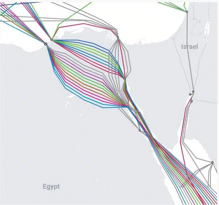
– 데이터 케이블: 전 세계 디지털 통신은 최대 99%, 금융 거래는 10조 건에 달합니다. 달러는 해저에 위치한 광섬유 케이블을 통과합니다. 140만 킬로미터에 걸쳐 약 550개의 활성 및 계획 케이블이 있습니다. 많은 것들이 물뿌리개보다 거의 두껍지 않다고 Deutsche Bank는 설명합니다. 이러한 케이블은 간첩 행위, 파괴 행위, 사고로 인한 손상에 취약합니다.

– 해저 전력 케이블: 전력 인터커넥터를 통해 국가는 날씨가 더 좋은 이웃으로부터 더 저렴한 풍력 또는 태양광 발전을 구매할 수 있어 공급 보안이 강화되고 수요 관리가 더 잘됩니다. 그러나 방해 행위나 사고로 인해 파괴될 수 있습니다.
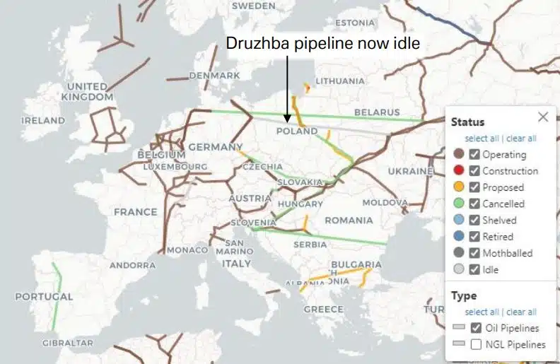
– 천연가스 파이프라인: 유럽은 천연가스 공급의 대부분을 파이프라인에 의존하고 있습니다. 2020년에는 러시아에서 약 40%의 천연가스를 수입했으며, 그 이후로는 노르웨이의 파이프라인과 LNG 수입에 의존해야 했습니다. Nord Stream 폭발 사고에서 알 수 있듯이 이러한 파이프라인은 방해 행위에 취약합니다.

– 송유관: 전 세계 송유관의 대부분은 유럽과 아시아에 위치하고 있으며 러시아에서 시작됩니다. 일반적인 송유관은 직경이 약 50cm이고 100만 리터(또는 시간당 6,300배럴) 이상을 운반할 수 있습니다. 이에 비해 배럴은 한 번에 200개 미만의 배럴을 운반할 수 있습니다. 파이프라인은 강철로 만들어지며 가능하면 땅에 매설됩니다. 천연가스 파이프라인과 마찬가지로 이 파이프라인도 손상, 지진, 파괴 행위에 취약합니다.
멀리 떨어진 곳에 있는 일부 철도와 도로는 세계 경제에 중요한 공급품을 불균형적으로 많이 운반하고 있으며 대안이 없습니다. 예를 들어, 콩고와 잠비아의 광대한 지역은 아프리카 최대의 구리 생산지이며 세계 코발트 생산량의 2/3를 차지합니다. 그러나 이러한 원자재를 광산에서 나미비아, 남아프리카, 모잠비크, 탄자니아의 항구까지 운송하는 도로는 모두 열악하고 혼잡한 4개뿐입니다. 세계 1위 수출국인 브라질의 콩에서도 비슷한 일이 일어나고 있습니다. 지난 2년 동안 중요한 수로인 강에 가뭄이 닥쳐 이러한 교통 수단이 얼마나 취약한지 보여줍니다.
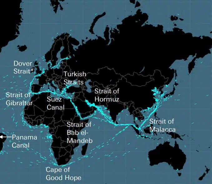
희망봉과 함께 해상 운송에 중요한 8개의 “해협”이 있습니다. 도이체방크(Deutsche Bank)가 설명했듯이, 도버 해협이 제거되고 파나마 운하, 터키 해협, 바브엘마데브 해협, 호르무즈 해협이 추가된다면 이는 대영제국의 5가지 “세계를 여는 열쇠”입니다. . 예를 들어, 석유의 경우 60% 이상의 공급량이 바다로 운송되며, 호르무즈 해협은 시장에서 가장 중요한 지점입니다. 전 세계 소비량의 5분의 1(LNG의 3분의 1)이 이곳을 통과하기 때문입니다. 호르무즈 해협의 가장 좁은 지점은 폭이 33㎞에 불과하다.
이 해협은 봉쇄, 선박 충돌 또는 좌초, 해적, 테러 공격, 전쟁 및 기름 유출과 같은 사고에 취약합니다.
항공 운송은 날씨, 전쟁 또는 지난 11월 중국 미사일이 지구 대기권에 진입할 수 있도록 스페인 영공이 폐쇄되는 등의 비정상적인 사건으로 인해 중단될 수 있는 보이지 않는 통로 네트워크에 의존합니다. 항공 교통 관제사의 파업은 올해 유럽에서 큰 교통 문제를 일으켰고, 전후 최대 규모의 항공 교통 봉쇄는 2010년 아이슬란드 화산 폭발로 발생했습니다.
세계는 미국 GPS(Global Positioning System)에 크게 의존하고 있습니다. 이는 약 30개의 지구 궤도 PNT(위치 확인, 항법 및 시간 측정) 위성을 사용하여 전 세계 40억 명 이상의 사용자에게 신호를 보냅니다. 그러나 이러한 신호는 약하고 간섭을 받기 쉬우므로 GPS가 "끊어지면" 미국에서만 하루 비용이 $10억을 초과할 것으로 추산됩니다.
(출처: https://www.moneyreview.gr/business-and-finance/125480/deutsche-bank-ta-aorata-diktya-poy-kinoyn-tin-pagkosmia-oikonomia-oi-5-adynamoi-krikoi/)

안전한 해상 항해 계획을 위한 해상 항법 제품 및 서비스의 모든 최고 제공업체 찾기


