舊的,未更新的(甚至幾個星期以來) 海圖 絕不能用於海上航行和航程規劃。特別是在海圖上描繪的河流的特徵往往會不斷變化,海上或海岸的人工航標可能隨時發生變化。因此,切勿使用過時或不正確的海圖進行導航和航路規劃。每個海圖製造商還包括一個系統,用於通知海員海圖的更改、需要應用到海圖的更正和更新。
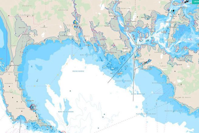
海圖是海域和鄰近沿海地區的圖形表示。根據圖表的比例,它可能會顯示 水深 和 土地高度 (地形圖),自然特徵 海底, 的細節 海岸線, 導航 危害, 的位置 天然和人造助劑 導航,信息 潮汐 電流,地球的局部細節 磁場,以及人造結構,例如 港口, 建築物, 和 橋樑.航海圖是航海必不可少的工具;許多國家需要船隻,尤其是商船來運載它們。海圖可以採用打印在紙上的海圖或計算機化電子海圖的形式。最近的技術已經可用 紙質圖表 哪個是 “按需”印刷 包含最近在印刷前一天晚上下載到商業印刷公司的製圖數據。每次每日下載時,關鍵數據(例如 給水手的地方通告 被添加到按需海圖文件中,以便這些海圖在打印時是最新的。 (資源: 海圖 en.wikipedia.org)
值得記住:正如《水手手冊》中所述,“沒有任何圖表是絕對可靠的。每張海圖都可能不完整”。
船橋上用於航路規劃的高級船員使用的航海圖必須不斷更新,以始終反映最新的 通知海員更正.如果發生海上事故,不這樣做將被視為疏忽,船長、管理人員和船東都可能被追究損害賠償責任。
深度變化、導航燈缺失以及新的沉船和障礙物只是水道上不斷變化的挑戰中的一小部分。很多這些變化對人眼來說是不可見的。商業船舶水手和休閒划船者都依賴海圖。
“與商業水手不同,休閒划船者不需要攜帶海圖。但隨著對我們的水道提出更多要求,繁忙的海岸意味著更多的事故風險,”美國國家海洋和大氣管理局海岸調查辦公室主任約翰洛厄爾上尉說,他補充說:“通過使用最新的圖表,人們有更好的機會避免潛在的擱淺和其他海上事故”。

由於海上和水下的條件不斷變化,我們必須擁有最新的數據以確保我們在海上的安全。最近有沒有沉船事故?如果有,它在哪裡,這樣我們就可以遠離它?是否有被暴風雨損壞的浮標,如果有,我們是否知道它以避免在夜間撞毀它?是否在特定區域報告了較淺的深度,如果是,我們怎麼知道?因為信息總是在變化,所以一個萬無一失的、受控的、 認證海圖校正系統 是必須的。除海圖外,此更正和更新系統還包含所有水文測量出版物。
美國各政府部門通過以下方式提供海圖更正和新版本通知 給水手的通知, 給水手的當地通知, 更正摘要, 向水手廣播通知.通過無線電廣播提前通知水手緊急更正。
美國國家海洋和大氣管理局 出版“POD”(按需印刷)NOAA 海圖的美國印刷合作夥伴,其中包括印刷海圖時的最新更正和通知。
一個 海圖和出版物更正記錄卡系統 是跟踪修正的有效方法。當一個新的 給水手的通知 到達時,導航器不會立即更新投資組合中的每個圖表,而是為每個圖表創建一張卡片並在這張卡片上記錄更正。
當需要使用圖表時,他將其連同圖表卡片一起從抽屜中取出,並對圖表進行必要的修改。這種方法可確保所有圖表在使用前都得到正確糾正。
各種各樣的 水手系統的數字通知, 如 數字追踪, 航海者, 要么 圖表公司,可在市場上修改英國海軍部和 NOAA 圖表。只有船舶特定的更正通過電子郵件或網絡下載發送,從而減少了海事安全信息對每個圖表的修訂進行分類的時間。同時,提供跟踪以幫助更正。
這 加拿大海岸警衛隊 發布海員通知,通知海員有關影響加拿大水域的主要航行安全問題。該電子文檔可從 水手須知 (NOTMAR) 網站每月一次。海員須知中的信息以更易於修改的方式排列 紙質圖表 和 航海刊物.
最近給水手的通知和檔案 希臘海軍水文服務: 2022 年年度(永久)通知、當前航海出版物更正清單、海員通知累積清單、飛行員修正案、 水手須知 – 存檔
免費下載海員通知和修正區 – 日本海員電子通知 NtM 每週五發布。
澳大利亞水手須知 是澳大利亞水文局 (AHO) 出版的紙質航海圖和紙質航海出版物的更正機構。
這 更正摘要 (與給海員的通知 – NtM 密切相關)分為五個部分。每個部分(卷)涵蓋了全球的一大片區域,包括海圖的多個區域和多個子區域。第 5 卷中還包含經航海通知 (NtM) 修訂的特殊海圖和出版物。
更正摘要包含累積的海圖更正,使用適當數量的更正摘要和所有隨後的海員通知任何海圖(無論其打印日期如何)都可以使用摘要進行更正。
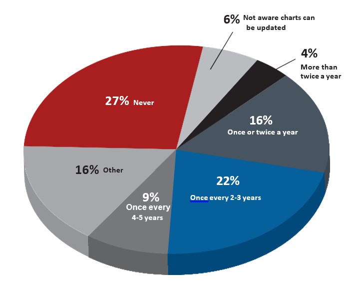
如果您是一個謹慎的航海者並且沒有記錄更正並且您的海圖已經超過幾週了,那麼您應該得到一個新的、更新的航海圖。
有多種方法可以糾正 電子海圖 (ENC) 也。
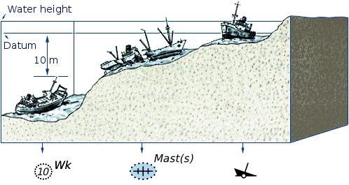
海圖基於水文測量。由於測量費時費力,許多海域的水文數據 可能會過時 和 並不總是可靠的.深度以多種方式測量。歷史上使用了測深線。在現代,回波測深用於測量公海中的海床。在測量整個障礙物(例如沉船)上的安全水深時,通過用一段水平線掃過該區域來檢查最小深度。這確保難以找到的突出物(例如桅杆)不會對航行在障礙物上的船隻造成危險。
海圖是由權力發布的 國家水文局 在很多國家。與商業出版商製作的圖表相比,這些圖表被認為是“官方的”。許多水文辦公室通過他們的銷售代理定期(有時是每週)手動更新他們的圖表。個別水文局生產 國家海圖系列 和 國際海圖系列.由協調 國際水文組織, 國際海圖系列是一個全球性海圖系統 (“INT”圖表系列),它的開發目標是盡可能多地統一海圖系統。
也有商業出版的圖表,其中一些可能包含特別感興趣的附加信息,例如游艇船長。
(來源: en.wikipedia.org)

這 海圖和出版物目錄 每年都會發布最新版本和更新版本的海圖,但是,如果在這一年中,每週 海員須知 (NtM) 指明任何新版本或新海圖,這些應由船隻的航行官插入海圖目錄中 (閱讀更多…)
修正和更新航海圖的過程是一項持續不斷的、永無止境的任務。在發布金鐘(航海)海圖後,必鬚髮布不斷變化的航行特徵和輔助設備以及其他相關信息,以使船舶在這些區域的航行海圖保持最新。海圖更正和更新提供給海船 電子的 或在 紙, 打印格式。
Admiralty Notices to Mariners (NtM) 以及每週通知,只是用於修改和更新海圖的一些方法,有幾種方法可以更正和更新航海圖 - 列表是:
(閱讀更多…)
一個 海圖 是水手可以擁有的最重要的工具之一。海圖是海洋導航圖,詳細描繪了海岸線和海底的結構。它包括有關水深、存在航行危險的位置、助航設施、錨地的位置和特徵以及其他特徵和元素的信息。
為了安全的海上航行和航行計劃,海圖是必不可少的。海員使用海圖以安全有效的方式規劃航次和航行船舶。商船在通過美國水域時必須攜帶電子或打印海圖。
使電子和紙質海圖保持最新是划船者在水上保持安全的一種簡單方法。
隨著衛星、聲納、激光雷達和 GPS 的出現,今天的製圖對於地圖製作者來說變得更快、更準確。此外,划船者可以利用電子海圖更新和 按需打印紙質圖表 包含最新的更新和通知。如今,海員可以輕鬆訪問海圖更新。
——
給海員的通知 (NtM) 是對海圖和出版物的更正。 NtM 僅包含對海上安全至關重要的信息。海員有義務通過在他們的航海圖和出版物上應用海員通告 (NtM) 來使他們的產品保持最新——直到發布新版本


