Old, non updated (since even few weeks) Nautical Charts should never be used for maritime navigation and voyage planning. The characteristics of a river, in particular, portrayed on a marine chart tends to change continuously, and artificial navigational aids at sea or shores may be altered at any time. As a result, never use obsolete or incorrect nautical charts for navigation and passage planning. Every manufacturer of nautical charts also includes a system for notifying seafarers of changes to the chart, correctios and updates needed to be applied to the chart.
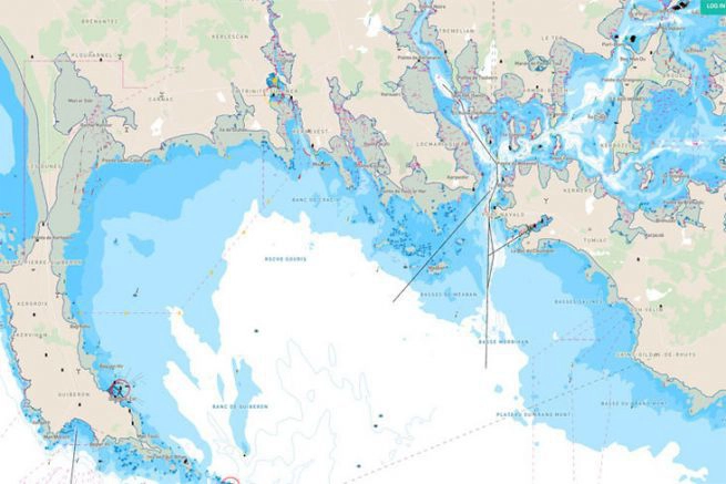
A nautical chart is a graphic representation of a sea area and adjacent coastal regions. Depending on the scale of the chart, it may show depths of water and heights of land (topographic map), natural features of the seabed, details of the coastline, navigational hazards, locations of natural and human-made aids to navigation, information on tides currents, local details of the Earth’s magnetic field, and human-made structures such as harbors, buildings, and bridges. Nautical Charts are essential tools for marine navigation; many countries require vessels, especially commercial ships, to carry them. Nautical charting may take the form of charts printed on paper or computerized electronic navigational charts. Recent technologies have made available paper charts which are printed “on demand” with cartographic data that has been downloaded to the commercial printing company as recently as the night before printing. With each daily download, critical data such as Local Notices to Mariners are added to the on-demand chart files so that these marine charts are up to date at the time of printing. (source: Nautical Chart en.wikipedia.org)
Worth to remember: as stated in the Mariners Handbook, “No chart is infallible. Every nautical chart is liable to be incomplete”.
The navigational chart in use by the officers on the vessels’ bridge for the passage planning must continually be updated to always reflect the most recent Notices to Mariners corrections. In the event of a marine accident, failure to do so will be considered negligence and the captains, managers, and vessel owners may all be held accountable for damages.
Changes in depth, missing navigational lights, and new wrecks and obstructions are just a few of the challenges that are continuously changing on the waterways. A lot of these alterations aren’t visible to the human eye. Commercial ship mariners and recreational boaters both rely on nautical charts.
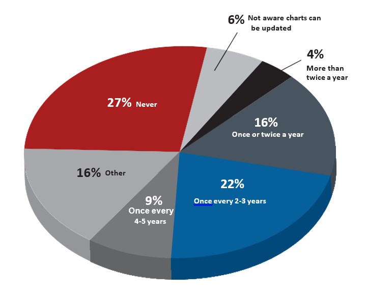
“Recreational boaters, unlike commercial mariners, are not required to carry nautical charts. But as more demands are put on our waterways, busy coasts mean more risk for accidents,” says Capt. John Lowell, director of NOAA’s Office of Coast Survey who added: “By using charts that are current, people have a better chance of avoiding potential groundings and other sea accidents”.

Because conditions at sea and beneath the water are constantly changing, we must have the most up-to-date data to ensure our safety at sea. Is there a recent wreck, and if so, where is it so we can stay away from it? Is there a buoy that has been damaged by a storm, and if so, do we know about it so that we can avoid crashing with it at night? Are shallower depths reported in a specific region, and if so, how do we know? Because information is always changing, a foolproof, controlled, and certified system of chart correction is required. Beside the charts, this corrections and updates system encompasses all hydrographic survey publications as well.
Various governmental departments in e.g. the United States give Chart Corrections and notices of new editions via Notice to Mariners, Local Notice to Mariners, Summary of Corrections, Broadcast Notice to Mariners. Mariners are given advance notice of urgent corrections via radio broadcasts.
NOAA’s printing partner in the United States that publishes “POD” (print on demand) NOAA nautical charts, which include the most recent corrections and notifications at the time of printing of the Marine Chart.
A Chart and Publication Correction Record Card system is an effective approach to keep track of corrections. When a new Notice to Mariners arrives, the navigator does not immediately update every chart in the portfolio, he instead creates a card for each chart and records the correction on this card.
When it’s time to use the chart, he pulls it out of the drawer, along with the chart’s card, and makes the necessary modifications on the chart. This approach ensures that all charts are correctly rectified before being used.
Various Digital Notices to Mariners systems, such as Digitrace, Voyager, or ChartCo, are available on the market to amend British Admiralty and NOAA charts. Only vessel-specific corrections are sent by e-mail or web download, cutting down on the time Maritime Safety Information takes to sort through revisions for each chart. At the same time, tracings to aid corrections are provided.
The Canadian Coast Guard publishes the Notice to Mariners, which notifies mariners about major navigational safety issues that affect Canadian waters. This electronic document is available for download from the Notices to Mariners (NOTMAR) Web site on a monthly basis. The information in the Notice to Mariners is laid out in a way that makes it easier to modify Paper Charts and Nautical Publications.
Recent Notice to Mariners and archive of the Hellenic Navy Hydrographic Service: Annual (Permanent) Notices 2022, Current List of Corrections of Nautical Publications, Cumulative List of Notice to Mariners, Amendments to pilots, Notices to Mariners – Archive
Free Download of Notice to Mariners & Correction Blocks – Japanese Electronic Notice to Mariners NtM is issued every Friday.
Australian Notices to Mariners are the authority for correcting paper navigational charts and paper nautical publications published by the Australian Hydrographic Office (AHO).
The Summary of Corrections (close companion to the Notice to Mariners – NtM) is divided into five parts. Each part (volume) covers a large area of the globe, including multiple regions and numerous sub-regions of nautical charts. Special charts and publications revised by the Notice to Mariners (NtM) are also included in Volume 5.
Summaries of Corrections contain cumulative chart corrections, using the appropriate volume of the Summary of Corrections and all subsequent Notices to Mariners any chart – irrespectively of its print date – can be corrected using the summaries.
If you are a prudent mariner and have not kept note of corrections and your marine chart is more than several weeks old, you he should get a new, updated, Nautical Navigation Chart.
A variety of ways exist for the correction of Electronic Navigational Charts (ENCs) too.
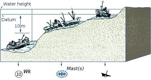
Marine Charts are based on hydrographic surveys. As surveying is laborious and time-consuming, hydrographic data for many areas of sea may be dated and not always reliable. Depths are measured in a variety of ways. Historically the sounding line was used. In modern times, echo sounding is used for measuring the seabed in the open sea. When measuring the safe depth of water over an entire obstruction, such as a shipwreck, the minimum depth is checked by sweeping the area with a length of horizontal wire. This ensures that difficult to find projections, such as masts, do not present a danger to vessels navigating over the obstruction.
Nautical charts are issued by power of the national hydrographic offices in many countries. These charts are considered “official” in contrast to those made by commercial publishers. Many hydrographic offices provide regular, sometimes weekly, manual updates of their charts through their sales agents. Individual hydrographic offices produce national nautical chart series and international nautical chart series. Coordinated by the International Hydrographic Organization, the international chart series is a worldwide system of charts (“INT” chart series), which is being developed with the goal of unifying as many nautical chart systems as possible.
There are also commercially published charts, some of which may carry additional information of particular interest, e.g. for yacht skippers.
(source: en.wikipedia.org)

The Catalogue of Admiralty Charts and Publications is published every year with current and updated editions of marine charts, however, if during the year the Weekly Notices to Mariners (NtM) indicate any new editions or new charts, these should be inserted in the chart catalogue by the vessel’s navigating officer (read more…)
The process for correcting and have the nautical navigational charts up-to-date is a constant, never ending task. Following the publication of an Admiralty (Nautical) Chart, continually changing navigational features and aids, as well as other pertinent information, must be promulgated in order to keep ships navigating charts in those areas up to date. Charts Corrections and Updates are provided to sea vessels electronically or in paper, print format.
Admiralty Notices to Mariners (NtM), as well as Weekly Notices, are just some of the ways used to revise and update charts, there are several methods for correcting and updating navigation charts – the list is:
A nautical chart is among the most important tools a mariner can have. Charts are marine navigational maps that draws in detail how the shoreline and seafloor are structured. It includes information on water depths, location with navigational hazards, the locations and characteristics of navigational aids, anchorages, and other features and elements.
For safe maritime navigation and voyage planning, a nautical chart is indispensable. Charts are used by mariners to plan voyages and sail ships in a safe and efficient manner. Commercial vessels must carry electronic or print nautical charts while transiting US waters.
Keeping electronic and paper charts up to date is a simple method for boaters to stay safe on the water.
Charting today is faster and more accurate for mapmakers with the advent of satellites, sonar, LIDAR, and GPS. Additionally, boaters can take advantage of electronic chart updates and print-on-demand paper charts that incorporate the latest updates and notices. Nowadays mariners can easily access chart updates.
– – –
Notices to Mariners (NtM) are corrections to nautical charts and publications. NtM only contain information which is vitally important to safety at sea. Mariners are obliged to keep their products up-to-date by applying the Notices to Mariners (NtM) on their nautical charts and publications – until a new edition is issued


Find all top providers of Marine Navigation products & services for safe Maritime Voyage Planning