(right below its treated the difference Raster/Vector in regards to graphics – look further below for the difference between Vector Nautical Charts (VNC) and Raster Nautical Charts (RNC))
There is some confusion to many people when it comes to the differences between vector and raster graphics. Its relatively easy to explaining the distinction, pros and cons.
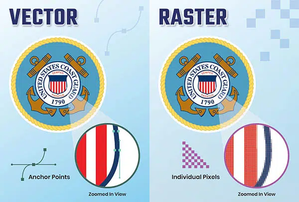
A raster image is similar to a pixel mosaic.
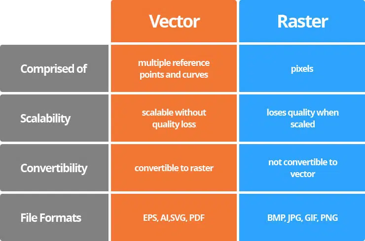
Each pixel is a tiny square with a specific color assigned to it, and they are combined in a mosaic-like pattern to generate an image. And more pixels per unit are equals higher resolution.
Individual pixels are usually not visible unless the resolution is low or you zoom close on a raster image.
When you zoom in to isolate individual pixels, you can use a tool like Adobe Photoshop to modify photographs with extreme precision. Simply delete or modify the color of individual pixels until you get the desired result.
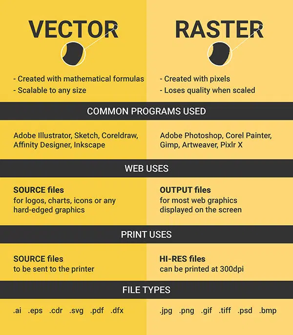
When it’s vital to display a seamless movement of shades and colors, such as in images, raster graphics are optimal. Catalogs, flyers, postcards, stationery, and other everyday projects benefit greatly from raster graphics.
Even when they appear to be identical, raster images take up more hard disk space than vector ones.
Because raster files contain information on each pixel in the visual, this is the case. Although compression techniques can help with this, if space is an issue, these graphics may be difficult to work with. .bmp, .gif, .jpeg, .jpg, .png, .psd, and .tif are examples of raster graphic file formats.
Raster graphics have the following advantages: they are simple to use, produce fine color gradations, and are easy to edit using common tools like Photoshop and Microsoft Paint. The main drawback of raster graphics is that they are not always suitable for producing high-quality printed goods, particularly when the desired end product is a book.
Graphics in vector format
A vector graphic is built up of pathways, each with a vector or mathematical formula controlling its shape and color. Control points with curves between them can be seen in a vector graphic, just like in a child’s connect the dots game.
The vectors are as follows.
Vector graphics are scalable because the vectors are mathematically defined. They may be blown up to any size without losing clarity or acquiring the fuzzy, pixelated features that you notice when zooming in on raster images. As a result, vector drawings are great for logos and other projects that require sharpness at a variety of sizes.
The most common vector graphics editors are Adobe Illustrator and CorelDraw. .ai, .cdr, and .eps are examples of common vector file formats. Vector graphics are most typically utilized in the printing of brochures, business cards, large signage, logos, window graphics, and other projects that include designs, logos, symbols, and/or text—anything that isn’t pictures or sophisticated, multi-hued designs that require fine color gradations.
Vector graphics have the advantage of producing the most exact and clear designs at any scale.
Vector graphics, on the other hand, necessitate expert design tools and skill in ability to use these.
The advantages and disadvantages of rasters and vectors
When should I use raster graphics and when should I use vector graphics?
Raster images and Adobe Photoshop are required for pictures; vector images and Adobe Illustrator are required for letterhead, typography, logos, and other simple graphic elements. Follow these guidelines if you’re not sure which type of graphic to use.
If you’re working on a photo with numerous colors, raster images are the way to go. Choose vector pictures if you’re drawing anything with a limited amount of colors. You may also make a project that incorporates both images and logos, or both types of graphics.
Finally, keep in mind that you can easily convert a vector graphic to a raster file.
It does not, however, work in both directions. In most cases, a raster file cannot be converted to a vector file.

What if I don’t know if my file is vector or raster?
This may appear to be a ridiculous question, but it isn’t. Even if the file extension indicates that the item is a vector graphic, it could be a raster graphic that was opened and saved in Illustrator, for example. The only way to be sure is to open the file and examine a section of the design closely. You can tell it’s a vector graphic if you see the vector editing nodes.
Conclusion
Raster images, despite their loss of clarity at bigger scales and oftentimes unmanageable file sizes, are ideal for clear images like photos that express subtle gradations of color, shade, and light. Despite their inability to generate completely seamless color transitions, vector graphics are great for scalable designs with fewer colors. Have your design in both formats, or in vector form to convert afterwards, to cover all of your bases.


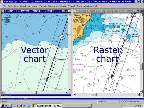
In Raster chart the entire nautical chart is saved in one layer – whereas in vector chart, information is saved in many layers.
In Raster chart customisation is not possible – whereas vector charts can be designed as per the requirements of the user.
Raster chart is direct copy of paper chart – whereas Vector chart is a computer generated chart.
Raster Chart appears cluttered – whereas in vector charts cluttering can be avoided.
In Raster chart information can be only added only, Whereas in vector chart information can be added as well as subtracted.
In Raster chart interrogation for information is not possible – in vector chart interrogation for information is possible.
In Raster chart Display Regeneration takes time – in case of Vector chart Display Regeneration is faster.
In Raster chart safety depth, Entering TSS, etc, alarm is not possible -whereas in Vector chart alarm is possible.
In Raster chart the colours and symbols are as per the paper chart – whereas in Vector chart symbols and colours are as per IMO publication guidelines. (the Inetrnational Maritime Organisation (IMO) Performance Standard requires that all IMO approved ECDIS follow the International Hydrographic Organisation (IHO) Colors & Symbols Specifications)
In Raster chart Scale of chart cannot be changed – whereas in Vector chart we can change scale.
Raster charts are simple and cheaper to produce and easily available – whereas Vector charts are costly and time consuming to produce.
Worldwide coverage is possible in Raster chart – in Vector charts worldwide coverage will take time.
Memory requirement is higher in case of Raster charts.
In Raster chart during look ahead / review other charts will be on different scale – whereas in Vector chart during ahead / review all charts will be on same scale.
Raster chart is a single layer, No info can be lost or ignored – whereas in Vector chart loss of info, or ignorance of a layer, is possible.
In Raster charts seamless chart is not possible – in Vector charts seamless chart is a possible feature.
For permanent correction in Raster nautical charts (RNC) the chart has to be replaced – in case of Vector nautical charts (VNC) only ENC Database is corrected.


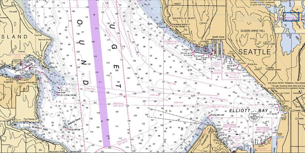
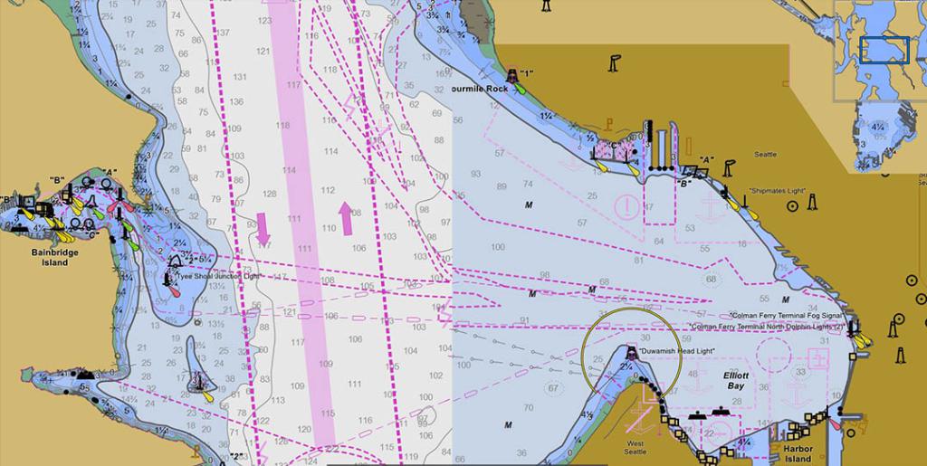
A Raster Chart is basically just a visual scan of a paper chart. It is a computer-based system which uses charts issued by, or under the authority of, a national hydrographic office, together with automatic continuous electronic positioning, to provide an integrated navigational tool. A vector chart is more complex. See: DIFFERENCES BETWEEN RCDS AND ECDIS (by IMO – International Maritime Organisation)
Raster data is produced by scanning a paper chart. This process produces an image that is an exact replica of the paper chart and which comprises a number of lines that are composed of a large number of coloured dots, or pixels. This technique does not recognize individual objects, such as a sounding, which limits its ability to conform to certain international guidelines. However, the use of what is termed a vector overlay, which can display specified user data such as waypoints and system data such as radar overlays etc., can overcome this deficiency. See more at: https://marinegyaan.com/what-are-raster-charts/
Vector Charts are the most common type of electronic Charts. They provide a computer-generated representation of a Chart, and contain all the information required (lot more additional information vs raster charts) for safe navigation.
Canadian Hydrographic Service (CHS): What is the difference between a raster chart and a vector chart?
Navigational charts are available in digital form as either a Raster Navigational Chart (RNC) or as a vector Electronic Navigational Chart (ENC). Both charts use navigation software to provide navigators with an electronic alternative to paper charts, resulting in safer navigation.
RNCs are simply an electronic image of a paper chart. They are digitized by scanning the paper chart and converting each line to a raster picture element or “pixel”. Beyond geo-referencing (positioning the scanned chart so that it appears in the right location with correct x and y coordinates), there is no intelligence or extra data in the raster image.
ENCs are “smart charts”, which means the user can click on different features, such as a light or buoy, to retrieve additional information not available in paper or raster charts. For example, a wharf appears only as an image on an RNC, but an ENC can identify it as a wharf and attach attributes to it such as height, length, age, ownership, number of berths, etc.
ENCs used on an Electronic Chart Display and Information System (ECDIS) and integrated with other data such as GPS position, radar, planned routes, heading, speed, and draught, assist mariners and alert them to sailing hazards, warnings, and dangerous situations. ENCs are powerful and flexible navigational tools that provide users with more control over the display of the chart. See more at: https://www.charts.gc.ca/charts-cartes/digital-electronique/raster-enc-eng.html
IMO SOLAS V/19 (SOLAS stands for: Safety of Life at Sea) outlines requirements for the types of charts ships are required to carry:
2.1 All ships irrespective of size shall have:
2.1.4 Nautical charts and nautical publications to plan and display the ship’s route for the intended voyage and to plot and monitor positions throughout the voyage. An electronic chart display and information system (ECDIS) is also accepted as meeting the chart carriage requirements of this subparagraph. Ships to which paragraph [2.10] applies shall comply with the carriage requirements for ECDIS detailed therein;
2.1.5 Back-up arrangements to meet the functional requirements of subparagraph 2.1.4, if this function is partly or fully fulfilled by electronic means*;
Footnote to regulation 2.1.4
*Paper nautical charts sufficient to meet the requirements of sub-paragraph .4 and regulation 27 may be used as a back-up arrangement for ECDIS. Other back- up arrangements for ECDIS are acceptable (see Appendix 6 to resolution MSC.232 (82), as amended.)
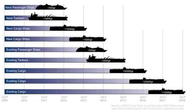
A majority of cargo ships, tankers, passenger ships, and mega yachts use electronic chart display and information systems (ECDISs). An amendment to SOLAS requires these vessels to use ECDIS as a primary means of navigation. By 2018, all such vessels will be required to use ECDIS. A graph of the ECDIS mandating timetable can be seen below.
It is not enough for a vessel to simply have an ECDIS on board. To be in compliance with SOLAS regulations and to pass port state inspections the ECDIS on a vessel must contain the appropriate electronic charts for the vessel’s intended voyage. There are two types of electronic charts that an ECDIS can display: Raster Navigational Charts (RNCs) and Electronic Navigational Charts (ENCs), otherwise known as vector charts. See more at: https://www.amnautical.com/blogs/news/17037716-ecdis-vector-charts-raster-charts
Raster Chart Display System RCDS
what are the advantages of raster charts?
what are raster charts in ECDIS


Find all top providers of Marine Navigation products & services for safe Maritime Voyage Planning