On April 13, the US federal government’s National Oceanic & Atmospheric Administration (NOAA) announced it will soon stop printing traditional lithographic (paper) nautical charts – while other forms of nautical charts, such as print-on-demand charts and electronic charting system versions (ENC) will continue to be produced.
Nautical charts provide hydrographical, nautical and topographical information to Mariners worldwide.
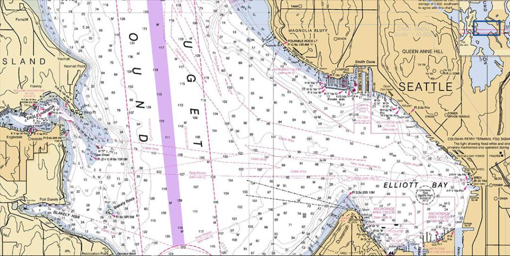
The amount of information provided on a nautical chart depends on the scale of the charts. The larger the scale, the more information is provided in the marine chart. Large scale nautical charts at a scale of 1:30.000 provide very detailed information about a specific maritime area and are preferred by seafarers for passage planning. On the other hand, small scale nautical charts, such as those at 1:2.000.000, offer little, non detailed information and are most appropriate for general maritime route planning. The largest scale nautical charts are frequently subjected to updates: Chart Corrections. This is only one of the numerous reasons why large scale marine charts should be used whenever possible.
What in summary does the “End of life of Nautical Paper Charts” mean?
Since 2020, National Oceanic and Atmospheric Administration (NOAA) in US, has begun phasing out raster charts (paper charts). But this includes too digital images of raster nautical charts and booklet charts. So, by January 2025, NOAA will no longer produce raster nautical chart products (both: paper Nautical Charts, which are the print out of raster nautical charts, and also digital raster Nautical Charts). This also means that the existing 5-digit raster chart numbers will be retired. The existing print-on-demand paper raster charts will also be going away. After 2025 only Digital Nautical Charts (electronic nautical charts – ENCs) will be produced.
What is the timeline for the “End of life of Nautical Paper Charts”?
As the re-scheming process advances, no equivalent raster charts for the new bigger scale ENC coverage will be developed. NOAA raster nautical charts will be phased out between 2020 and 2023. When a chart is marked for cancellation, the print-on-demand version is updated with a notation indicating that it is the last edition of the chart, and it will be discontinued 6 to 12 months later. The NOAA “List of Latest Editions” webpage and the Local Notice to Mariners (NtM) will be updated with the final notification of a chart’s cancellation.
Soon therefore, Mariners won’t be able to buy the NOAA’s nautical paper charts. But there is an alternative: printing your own, up to date, backup, nautical paper charts from the digital version of Nautical Charts (Vector Nautical Charts VNCs) – and at a fraction of the price.
What is the future of “Nautical Paper Charts”?
The use of paper nautical chart products based on ENC data will continue to be promoted by NOAA, either through the NOAA Custom Chart online tool or through third-party commercial providers supplying ENC-based chart products. The NOAA Custom Chart (NCC) is a prototype that is still being developed and is available online. Users can customise the scale and paper size of custom-made nautical charts, as well as the centred location. After that, the NCC creates a geospatially referenced Portable Document Format with chart notes on a separate PDF page. These PDFs can then be downloaded, viewed, and printed. Visit https://devgis.charttools.noaa.gov/pod to try out the NCC prototype.
What will happen to Local Notice to Mariners service offered?
The United States Coast Guard’s Local Notice to Mariners (LNM) is the principal way of communicating information about aids to maritime navigation, risks to navigation, and other essential information for mariners. Mariners have been allowed to make hand adjustments on paper nautical charts thanks to these notices. There will be no need for Section IV, “Chart Corrections,” in the Local Notice to Mariners once NOAA stops producing raster paper charts. It is unclear how updates to NOAA Custom Charts will be notified at this time. Because traditional charts and chart numbers will cease to exist in the United States in the not-too-distant future, other sections of the Local Notice to Mariners that now refer to chart numbers will have to rely on alternative methods of communication. Perhaps, instead of chart numbers, delineating inlets, bays, and harbors will become the new standard.
– – – – – – – – – – –
Raster charts are on their way out, and new Vector Charts (electronic nautical charts – ENCs) are on their way in.
By January 2025, NOAA expects to phase out all raster chart products in favour of vector charts, according to a timeline released in November 2019. NOAA produced a Draft National Charting Plan more than two years ago, which includes intentions to phase out raster charts. Following a public comment period, NOAA released its National Charting Plan in November 2017, which featured a focus on vector chart products. These two NOAA publications, taken together, describe the future of nautical charts.
The future of charts is a wide-ranging topic. NOAA’s plan to phase out all raster products, on the other hand, is gaining a lot of attention.
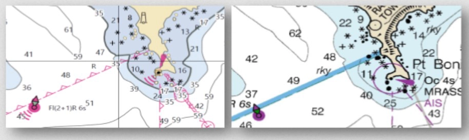
Currently, boaters can choose between Raster Navigation Charts (RNC) and Vector Electronic Navigation Charts (VEC) (ENC). Cartographers develop raster charts, which are digital or paper images of traditional nautical charts. The symbols, lines, and tints that make up a chart are formed by rows of colour pixels, or dots of ink, in the electronic image. Vector charts are digital representations of characteristics that are stored as pairs of latitude and longitude coordinates (as opposed to a matrix of pixels). Each feature’s records go into greater detail on its colour, form, purpose, and other characteristics.
Paper nautical charts, raster navigational charts, and booklet charts are all examples of NOAA raster chart products. NOAA’s only nautical vector product is electronic navigational charts. NOAA isn’t the only one who creates raster charts. For inland waters, the US Army Corps of Engineers publishes raster charts, whereas the Canadian Hydrographic Service produces both raster and vector charts for Canadian waters.
Why are Paper Nautical Charts (Raster Nautical Charts) going away?
Raster charts and raster chart electronic images (RNCs) have existed for a long time. More than 180 years ago, the Coast Survey prepared and published the first paper charts. Improved vector or electronic charts (ENCs) are now possible thanks to new methodologies, equipment, and technology, which is NOAA’s goal for the next few years. The database for showing ENCs was first generated in 1993, which is deemed obsolete by today’s standards and requires updating. It’s worth noting that the US government is taking proactive steps to upgrade the database so that more information can be displayed on vector charts. While the Army Corps of Engineers, the Canadian Hydrographic Services, and other foreign governments continue to provide raster charts, NOAA has determined that maintaining two types of chart products that serve essentially the same purpose is too time consuming and not cost effective; instead, NOAA would rather focus their efforts on producing more detailed ENC charts with new benefits. The idea is that ENCs are the most efficient way to convey updated navigational information, whereas raster chart products lag behind their ENC counterparts.
What are the pros and cons of Raster (Paper) Nautical Charts vs Digital (Vector) Nautical Charts
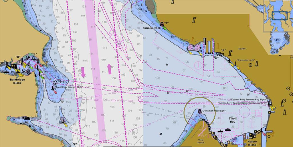
The visual appeal of raster charts, which are generated by cartographers, has grown in popularity among boaters. We like the elevation illustrations along the shoreline that illustrate mountains and other land features, as well as the raster maps’ more detailed sea depth statistics. When zooming in on raster charts, there is a limit because electronic images of raster charts are stored as rows and columns of colour pixels. When zooming in on raster charts, the image blurs and loses detail. ENCs, on the other hand, allow for endless zooming to achieve the required level of detail. Rather than a matrix of pixels, the vector chart database stores characteristics as pairs of latitude and longitude coordinates. While vector charts do not have the same visual appeal as raster charts, there is a bright future for ENCs and vector charts.
NOAA is rescheduling all ENCs into a consistent, rectangular, gridded configuration over the course of several years. As a result, a product suite of over 9,000 ENCs (also known as cells) will be available; many of these cells will be gathered at higher scales than the ENCs they will replace, offering more extensive coverage. The new, larger-scale reschemed ENC charts are being compiled to provide additional depth and coastline data. The new S-100 ENC data standards will provide seafarers with accurate information on tidal range and water flow.
Edge matching of data on adjacent cells of the same or similar chart scales will be another ENC feature enhancement. Previously, each ENC cell was kept in its own database, making rescheming ENCs problematic. All ENC data will now be stored in a single, unified database known as the Nautical Information System (NIS). Previously, ENCs were compiled using 131 different scales; during the rescheming process, this will be reduced to 20 or fewer standardised scales. These standardised scales will meet the International Maritime Organization’s (IMO) ENC scales, which are required for the new S-100 series of products.
The goal is to provide a gridded framework that can be readily segmented or extended based on geographic location, while also improving consistency and level of detail.
– – – – – – – – – – – – – – –
28 August 2020 – an overview of issues and recommendations regarding Paper Nautical Charts in the current and future marine environment by the International Hydrographic Organization & Nautical Cartography Working Group.
The Nautical Cartography Working Group NCWG (of the International Hydrographic Organization IHO) has prepared this overview of significant issues related to the “Future of the Paper Nautical Chart”. This report is not an exhaustive study of global paper nautical chart production, distribution, and usage practices. Many of the sections are presented from the perspective of only one or just a few Hydrographic Offices. Although these experiences are typical for many hydrographic offices, the conditions and practices in other offices could differ. A survey conducted by the NCWG provided an opportunity for all IHO member states to share their individual circumstances. This report introduces important paper chart related issues that may require the IHO, individual hydrographic offices, regulatory organizations, mariners and other stakeholders to think about paper charts differently and to take appropriate actions to prepare for the future of the paper chart. The report makes recommendations for further consideration and for the possible development of additional IHO nautical cartographic guidance.
Sales and use of Paper Nautical Charts has declined by about half from 2008 to 2018, while use of Electronic Navigational Charts (ENCs) has increased about seven fold during the same period. The effort required to maintain paper and associated digital raster chart formats is now becoming disproportionate when compared to the growing use of ENCs. Hydrographic offices are now exploring different ways to reduce the burden of paper chart production, such as decreasing the number of charts in their suite of paper/raster chart products, or developing ways to create raster chart products directly from ENC data. Some efforts are also being made to make use of ENCs, or products derived from ENCs, more attractive to mariners and recreational boaters.
Use of Paper and Electronic Charts – related regulations: the International Convention for the Safety of Life at Sea (SOLAS), Chapter V, Regulation 19, “Carriage requirements for ship borne navigational systems and equipment,” specifies that “All ships, irrespective of size, shall have nautical charts and nautical publications to plan and display the ship’s route for the intended voyage and to plot and monitor positions throughout the voyage. An electronic chart display and information system (ECDIS) is also accepted as meeting the chart carriage requirements of this subparagraph.” Regulation 19 also states that “An appropriate folio of paper nautical charts [still] may be used as a back-up arrangement for ECDIS.”
In July 2018, the International Maritime Organization (IMO) mandated requirement for most commercial vessels on international voyages to be fitted with an Electronic Chart Display and Information System (ECDIS) came into full effect. Some national maritime authorities now also allow commercial ships on domestic voyages to navigate entirely with ENCs. It is noteworthy that only seven member states of the 48 responding to the NCWG survey indicated that only paper charts will meet carriage requirements. Most indicated that either ENCs or paper charts were acceptable. Many recreational boaters have also embraced the use of electronic charts. Although many of these users still keep some paper charts as a back-up or to comply with local regulations, the sales of paper charts has diminished over the past decade while use of ENCs has increased significantly. This, however, varies by country.
The United Nations Convention on the Law of the Sea (UNCLOS) defines various maritime limits, over which coastal states have certain rights, such as Territorial Seas, Contiguous Zones, Exclusive Economic Zones, and the Continental Shelf. The convention states the need to publish these limits on charts and deposit them with the United Nations, but the convention does not specify whether the charts are to be paper or electronic. It may be time for more nations to start reporting their maritime limits on ENCs. This would also support the greater use of GIS technology to share information and identify inconsistencies.
Users of Nautical Charts: In addition to conventional nautical chart users, such as professional mariners on international or domestic voyages; and recreational boaters plying lakes, rivers, bays and coastal waters, there are a number of other users of nautical chart data that are more difficult to categorize or account for. In fact, it is even difficult to determine the proportion of chart sales attributed to professional mariners verses recreational boaters, much less others using charts for any number of purposes, such as vessel traffic safety, defence, environmental planning, maritime and ice-related delimitations, tourism planning, fisheries management and other non-navigational purposes.
Single Source Chart Production Database: Several hydrographic offices have made a transition to a single nautical chart production database, which is used to produce both ENC and paper nautical chart products. This is sometimes accompanied by a transition in the relative proportion of production skills required. More cartographers are involved in database operations, compilation and ENC encoding work, while fewer are supporting paper nautical chart product generation and distribution.
Chart Product Suite changes: ENC data can take some time for the initial data encoding, but can easily be published from a production database with little additional effort. Paper chart products usually require additional, manual cartographic “finishing” operations before they can be published. Some hydrographic offices are also cancelling some paper charts while maintaining the corresponding ENCs or creating new, larger scale ENC coverage without creating equivalent paper charts. A few hydrographic offices are planning for the eventual cancellation of all of their raster chart products. The difficulty of electronic navigational systems in providing a “big picture” overview of a large area may be mitigated by the introduction of larger display screens aboard ships. In the meantime, there is some evidence that the need for small-scale general and sailing charts may persist. The sales of all scales of paper charts is falling, but sales of smaller scale charts are decreasing at a slower pace.
International (INT) Charts: The original intent of the IHO international (INT) chart concept was to facilitate the provision of charts suitable for international shipping and consistent compliance with international specifications. INT charts also enable IHO member states who provide charts outside their own national waters to print facsimile charts with only minor modifications. However, an increasing number of hydrographic offices are now reluctant to produce INT charts and maintain INT schemes, preferring that their national charts be adopted in lieu of INT charts as long as they are already produced in accordance with S-4 specifications. The situation is very different from one charting region to another and the future of the INT chart concept itself is now in question, especially given that larger SOLAS vessels are now required to navigate with ECDIS and ENCs.
Print on Demand: Several hydrographic offices are now using a mix of traditional printing (usually offset lithography) and “print on demand” (POD) methods. Many have completely transitioned to POD. Traditional printing methods require warehousing large numbers of pre-printed charts that need to have corrections applied when they are sold. For hydrographic offices that maintain critical (Notice to Mariners) corrections on the POD version of charts in-between new numbered editions of nautical charts, the POD process prints and immediately distributes fully updated charts as each user orders one – even in the middle of new chart editions. POD makes chart distribution more efficient, but it is still tied to traditional paper chart production. Chart (or Product) on Demand has the potential to create customized paper charts directly from a database.
Printing Paper Charts from ENC Data “Chart on Demand”: A few hydrographic offices are developing an alternative to traditional paper chart production that enables users to specify the extent, scale, and paper size of their own customized paper chart product. Any “chart on demand” product would necessarily look different than a standard chart. A primary difference is that chart layouts look more like the standardized designs used on many national topographic maps series. Some methods currently create a ready-for-printing raster product from ENC data using the IHO S-52 presentation library (symbology specified for use in ECDIS), because there are already rules in S-52 for mapping ENC feature/attribute values to standard symbology. There are also efforts to provide a more traditional (IHO S-4 based) rendering, but there are difficulties to overcome, as discussed in the next section.
Portrayal of Raster Charts with S-57 Attributed Data: Some efforts have been made to use ENCs or other S-57 attributed data to automatically apply IHO S-4 (also called INT1) symbology and legends on raster chart products, but there is not yet a universal method of undertaking this process. Each of these efforts must currently be undertaken by individual hydrographic offices. Some useful future research and development efforts that could facilitate sharing resources to expedite this process could include:
• Creation of precise symbol shape, size, and color specifications (engineering drawings) for S-4 symbols.
• Creation of a naming convention for and a standard library of digital symbol graphic files for S-4 paper chart symbols, perhaps in the same Scalable Vector Graphics (SVG) format used for the symbols for the new S-101 ENC product.
• Adaptation of S-52 look-up tables to point to paper chart symbols enumerated in an S-4 symbol catalogue.
This could also make it easier for S-101 development efforts to prototype using more paper-chart-like symbols for the portrayal of ENCs, something that many ECDIS users have shown a preference for. Ongoing development of the S-101 ENC Product Specification should also keep in mind that in addition to supporting the portrayal of ENC data in ECDIS, consideration should be given to how ENC encoding can be optimized to support the symbolization and printing of paper nautical charts from ENC encoded data.
The Back-up use of Paper Charts: Some hydrographic offices are considering the development of a simplified version of standard paper nautical charts that would reduce the need for chart “finishing.” These simplified products would be intended primarily as a back-up for electronic navigational systems. Although there is not strong support among NCWG or IHO member states in general at this time, there may be a role for the IHO to help develop a specification, or at least guidelines, for a simplified raster chart product for back-up sometime in the future.
Productions of Raster Navigational Charts: Raster Navigational Charts (RNCs) – digital images of traditional paper nautical charts – were once used as an alternate data source in ECDIS for areas in which no ENCs existed. Complete ENC coverage is now widely available, so the need for RNC data in ECDIS is no longer a significant factor for hydrographic offices to consider. Some hydrographic offices have ceased RNC production altogether, others continue to produce RNC data or RNC based raster tiles to provide digital base map data for other non-ECDIS navigational systems. Production of an RNC in any given area requires the same initial effort needed to create a traditional “paper chart” image.
Raster Tile Products: some hydrographic offices produce tiled raster chart data that can be used with GPS enabled electronic chart systems or other chart plotter display systems to provide real-time vessel positioning. Tiles are also being used on third party nautical data integration websites.
Source: International Hydrographic Organization IHO – https://iho.int/en/miscellaneous-1
Read the full report “The Future of the Paper Nautical Chart”, final report by IHO & NCWG
– – – – – – – – – – – – – – –
What are the changes?
Starting April 13, the federal government will no longer print traditional lithographic (paper) nautical charts, but will continue to provide other forms of nautical charts, including print on demand charts and versions for electronic charting systems.
What are the reasons for this?
The decision to stop production of paper charts is based on several factors, including the declining demand for lithographic nautical charts, the increasing use of digital (electronic) marine charts, and federal budget realities.
What are the concerns due to end of life or paper charts?
“With the end of traditional paper charts, our primary concern continues to be making sure that boaters, fishing vessels, and commercial mariners have access to the most accurate, up-to-date nautical chart in a format that works well for them,” said Capt.
NOAA-certified Print-on-Demand partners will continue to sell up-to-date paper nautical charts. NOAA’s Office of Coast Survey, which creates and maintains the nation’s suite of over a thousand nautical charts of U.S. coastal waters, announced major changes ahead for mariners and others who use nautical charts. Starting 2025, the federal government will no longer print traditional lithographic (paper) nautical charts, but will continue to provide other forms of nautical charts, including print on demand charts and versions for electronic charting systems.
“Like most other mariners, I grew up on NOAA lithographic charts and have used them for years,” said Rear Admiral Gerd Glang, director of NOAA’s Office of Coast Survey. “We know that changing chart formats and availability will be a difficult change for some mariners who love their traditional paper charts, but we’re still going to provide other forms of our official charts.” Most mariners now use Print-on-Demand nautical charts that are up-to-date to the moment of printing.
Since 1862, those lithographic nautical charts available in marine shops and other stores have been printed by the U.S. government and sold to the public by commercial vendors. The decision to stop production is based on several factors, including the declining demand for lithographic nautical charts, the increasing use of digital and electronic charts, and federal budget realities.
“With the end of traditional paper charts, our primary concern continues to be making sure that boaters, fishing vessels, and commercial mariners have access to the most accurate, up-to-date nautical chart in a format that works well for them,” said Capt. Shep Smith, chief of Coast Survey’s Marine Chart Division. “Fortunately, advancements in computing and mobile technologies give us many more options than was possible years ago.” NOAA will continue to create and maintain other forms of nautical charts, including the increasingly popular Print on Demand (POD) charts , updated paper charts available from NOAA-certified printers. NOAA electronic navigational charts (NOAA ENC®) and raster navigational charts (NOAA RNC®), used in a variety of electronic charting systems, are also updated weekly and are available for free download from the Coast Survey website. NOAA will also announce a new product full-scale PDF (Portable Digital Format) nautical charts , available for free download on a trial basis online Electronic charts, layered with multi-faceted information, are increasingly popular with commercial pilots around the world.
The world of navigation is benefiting from advances in technology, Smith explained. He said that NOAA will consult with chart users and private businesses about the future of U.S. navigation, especially exploring the use of NOAA charts as the basis for new products.
“Customers frequently ask us for special printed features, such as waterproof charts, special papers, or chart books containing additional information,” he said. “We are investigating new opportunities for companies to fill these market niches, using the most up-to-date information directly from NOAA.” NOAA’s Office of Coast Survey is the nation’s nautical chartmaker. Originally formed by President Thomas Jefferson in 1807, Coast Survey updates charts, surveys the coastal seafloor, responds to maritime emergencies, and searches for underwater obstructions that pose a danger to navigation.
Follow Coast Survey on Twitter @NOAAcharts
Check out the NOAA Coast Survey blog at noaacoastsurvey.wordpress.com
for more in depth coverage of coast surveying and nautical charting.
Source: noaa.gov
– – – – – – – – – – – – – – –
NOAA has already started to cancel individual charts and will shut down all production and maintenance of traditional paper nautical charts and the associated raster chart products and services by January 2025.
Mariners and other users of nautical charts are encouraged to use the electronic navigational chart (NOAA ENC®), NOAA’s premier nautical chart product.
Read more information about the Future of NOAA Charts Four Raster Chart Products NOAA produces raster charts in four formats:
Paper nautical chart
Full-size nautical chart
Raster navigational chart (RNC)
The common and unique characteristics of each of these raster formats are described below, including information about how to obtain copies of each type.
Common Features of all NOAA Raster Charts, including Paper Charts just as NOAA electronic navigational chart (NOAA ENC®) cells do, all raster charts portray water depths, coastlines, dangers, aids to navigation, landmarks, bottom characteristics and other features, as well as regulatory, tide, and other information. All raster chart products are based on and have the same appearance as the “traditional” paper charts that Coast Survey has provided for U.S. waters since the early 19th century.
They contain all critical corrections published in notices to mariners since the last new edition of the chart was released, as well as any newly compiled routine changes (see the “Chart Updates” sidebar on the right).
The U. S. Government no longer prints paper copies of its raster nautical charts. However, NOAA provides digital images of its raster charts to NOAA certified chart agents , from whom the public may purchase NOAA paper nautical charts.
Certified chart agents ensure that the charts are printed at the proper scale and quality to meet U.S. Coast Guard (USCG) chart carriage requirements. In fact, only charts printed by a NOAA certified chart agent are accepted by the USCG as meeting chart carriage requirements for commercial vessels. No other raster chart format meets USCG carriage requirements.
Some NOAA certified chart agents offer additional premium services, such as printing charts on waterproof materials, and printing user overlays on charts.
NOAA paper charts fulfill IMO requirements for ECDIS backup.
To purchase a paper nautical chart, contact a NOAA certified chart agent These are full size Portable Document Format (PDF) images of NOAA paper nautical charts. PDFs may be viewed with free PDF readers such as Adobe Acrobat Reader . Most modern web browsers can open these documents with no additional software.
Most, but not all, charts may be printed at true chart scale on plotters that accommodate 36″ wide paper.
Paper plots of full-size nautical chart PDFs DO NOT meet USCG chart carriage requirements for commercial vessels. Only NOAA paper nautical charts printed by a NOAA certified chart agent, who will ensure that the charts are printed at the proper scale and quality, meet USCG chart carriage requirements.
Source: nauticalcharts.noaa.gov
– – – – – – – – – – – – – – –
Mariners have been urged to keep a set of backup paper charts as long as electronic charts have existed, just in case the electronics fail. Back in the day, you had to travel to a store that sold authentic NOAA charts and look over hundreds of colorful charts before spending (up to $20 or more) for each chart you required. Those days are long gone, or soon will be. The National Oceanic and Atmospheric Administration (NOAA) recently stated that it will no longer publish nautical charts, with the service being phased out over the next five years. According to NOAA, it now produces two types of charts that serve the same purpose, and it makes sense to phase out paper charts in favour of the electronic form.
The National Oceanic and Atmospheric Administration (NOAA) has been maintaining raster versions of over 1000 paper nautical charts for years. Raster charts are pixelated pictures of charts that can be printed by NOAA’s approved print-on-demand (POD) chart agents. These raster charts, which include the Booklet Charts that many recreational boaters rely on, will be phased out by January 2025.
NOAA also generates around 1200 electronic navigation charts (ENCs) in a variety of scales to help plan a cruise or locate an anchorage. ENC charts are vector charts, which means they’re made of digital data that can hold a lot more information and be scaled more quickly. When you zoom into an electronic vector chart, you can see more detail as you hone in on a specific location – raster charts can’t do that. ENCs will be converted into a uniform, rectangular gridded style, bringing the total number of digital nautical charts to around 9000, according to NOAA. Many of the older charts will now be at a bigger scale, giving seafarers a lot more information. Users could use a prototype of the online NOAA Custom Chart application (NCC) to create their own charts using the most recent NOAA ENC data starting a couple of years ago. As the end of paper charts approaches, that system is improving. One of the most significant benefits of ENCs is that they are current at the time of creation. When you bought paper charts that were even a few weeks old in the past, you had to manually update them with the most recent Local Notice to Mariners, which could take a long time depending on how old the charts were.
If you like getting new traditional paper charts for your navigation, you’ll be out of luck shortly. However, you’ll be able to utilise NOAA’s NCC to print your own compact charts at a fraction of the cost of typical charts, with the opportunity to change area and details to fit your needs. If you don’t want to print your own ENC charts, you can purchase them from suppliers. It’s now easier and less expensive than ever to augment your chartplotter.
– – – – – – – – – – – – – – –
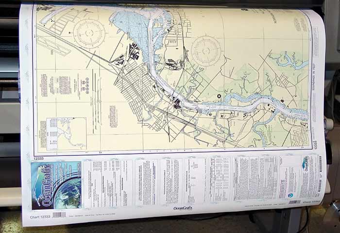
OceanGrafix, the first company to offer print-on-demand nautical charts, released a new white paper entitled, “Print-on-Demand Paper Charts: Why Serious Mariners Continue to Carry Paper Charts to Complement Digital Navigational Tools“. The paper addresses the importance of having an accurate paper chart on board and why recreational boaters should use paper charts in conjunction with today’s navigational technology.
– – – – – – – – – – – – – – –
UPDATE: on NOAA Coast Survey announced the release to the public of NOAA Custom Chart version 1.0 (source: NOAA – find NOAA’s News & Updates here)
On April 1, 2021, NOAA’s Office of Coast Survey released NOAA Custom Chart version 1.0, a dynamic map tool which enables users to create their own paper and PDF nautical charts derived from the official NOAA electronic navigational chart (NOAA ENC®), NOAA’s premier nautical chart product.
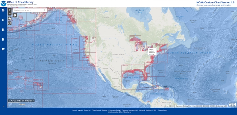
The online tool uses official NOAA ENC data to create nautical charts with customized scale and extent, which can then be downloaded as PDF files. The charts feature traditional chart components such as paper chart symbology – including NOAA-style symbols for aids to navigation and dangers to navigation, and a quality of data diagram. While these printable PDFs look a bit different from traditional paper charts, and (initially) will not meet carriage requirements for regulated vessels, NOAA Custom Chart utilizes the best available data, delivers an improved service for users, and ensures consistency between ENC and NOAA Custom Chart PDFs, resulting in the best quality chart regardless of the final format.
Read the NOAA announcement here and find out more at the NOAA Official website
The End of Traditional Paper Charts (article by International Hydrographic Review)
UKHO (UK Hydrographic Office) withdrawal from Paper Chart production – by end of 2026


Find all top providers of Marine Navigation products & services for safe Maritime Voyage Planning