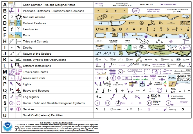
(* 來源: 美國國家海洋和大氣管理局 - 這 美國國家海洋和大氣管理局 (美國),美國科學和監管機構—— 紙質和電子海圖 ENC 上使用的符號、縮寫和術語)
查看紙上使用的符號的完整列表 海圖 (及其數字光柵圖像等價物)和用於描繪的相應符號 電子航海圖 (ENC) 數據 電子海圖顯示和信息系統 (ECDIS)。
https://www.nauticalcharts.noaa.gov/publications/docs/us-chart-1/ChartNo1.pdf
例子:
2019 年 4 月 15 日
由美國聯合編制
商務部——國家海洋和大氣管理局
國防部 - 國家地理空間情報局
用於在電子海圖顯示和信息系統 (ECDIS) 上顯示電子海圖 (ENC) 的符號系統已添加到美國第 1 號海圖中。
除了美國圖表 1 的傳統字母部分中顯示的 ECDIS 符號外,現在還有幾個專門的頁面專門用於提供有關 ECDIS 的重要細節。這些頁面通過 ECDIS 圖標進行區分,如本頁面左上角所示。 ECDIS 頁面也以斜體字列在目錄中。
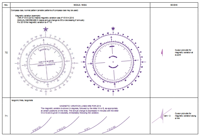
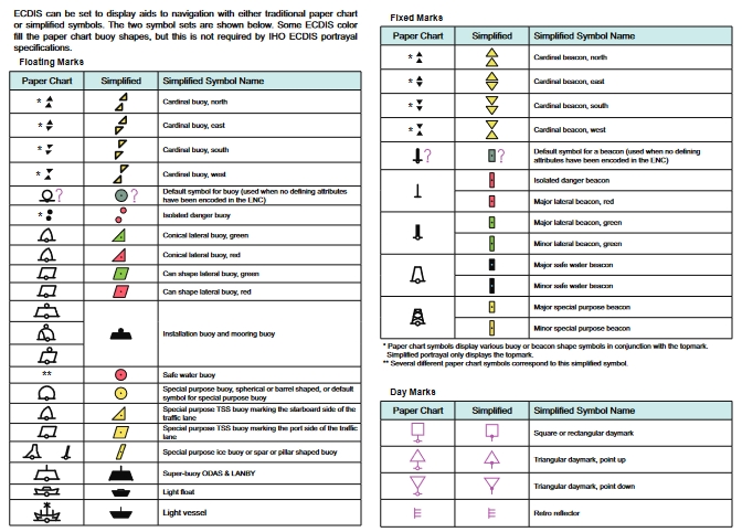
使用紙質海圖和 ENC 的一個主要區別是 ECDIS 能夠根據用戶設置和其他條件(例如船舶吃水)以不同方式顯示相同的特徵。一個重要的例子是,如果殘骸、岩石和其他障礙物位於或深於為船舶設定的安全等值線深度,則 ECDIS 會使用其傳統的“紙質海圖”符號顯示殘骸、岩石和其他障礙物。淺灘危險用左側所示的獨特 ECDIS“孤立危險”符號描繪。 (有關 ECDIS 安全等值線的更多信息,請參閱 ECDIS 深度描述頁面。)
與紙質海圖相比,ECDIS 提供的另一個優勢是使用戶能夠通過“光標選擇”獲得有關某個要素的更多信息。可以通過光標選擇獲得的一些特徵屬性值在整個美國圖表 1 中都有說明。如果特定值(例如高度、垂直間隙等)包含在 INT 符號描述中,則尤其如此。左側顯示的光標選擇圖標用於指示何時引用了光標選擇。
用戶可以通過光標選擇獲得許多其他屬性值,但未特別註明。這些包括但不限於目的、季節性、週期性、狀態、顏色、高度、結構類型以及特徵的視覺或雷達顯著性;浮標的形狀、顏色或顏色圖案;燈的特性;障礙物和殘骸的類別;雷達波長、無線電頻率、通信信道和呼號;存在 AIS 傳輸信號;有關引航服務的信息等等。
US Chart No. 1 是一個方便的指南 電子信息系統 用戶,但它不能替代強制性 ECDIS 培訓。
誠邀 ECDIS 用戶和開發者社區幫助改進美國圖表 1 中 ECDIS 符號和信息的呈現。請讓 NOAA 知道您希望在下一版中看到哪些其他信息。
有關美國第 1 號圖表的更正、評論或問題可通過 NOAA 海岸調查利益相關者參與和反饋網站 ASSIST 提交,網址為: www.nauticalcharts.noaa.gov/customerservice/assist,
或郵寄至:
美國國家海洋局,NOAA (N/CS2) 注意:US Chart No. 1
1315 East West Highway Silver Spring, MD 20912-3282
符號, 縮寫和術語
文檔部分和 ECDIS 頁面
簡介 5
原理圖 8
白天、黃昏和夜晚的調色板 9
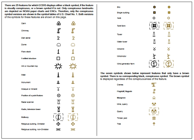
顯眼和不顯眼的特徵 28
ECDIS 深度描繪 47
ECDIS 69 中的路由措施示例
簡體和繁體紙質圖表符號 90
縮略語索引 111
索引 117
附錄 1,IALA 海上浮標系統 128
符號部分
一般的
地形
水文
導航 艾滋病 和 服務
查看完整文檔——紙質和電子海圖 ENC 上使用的符號、縮寫和術語)
在短時間內識別海圖中的七個重要危險符號,這些符號可能會在您的船體上裂開一個洞、損壞您的龍骨、彎曲螺旋槳軸、損壞螺旋槳或導致您擱淺.
今天海圖上使用了幾十種危險符號,但這裡有一些更常見的。了解這些“船舶殺手”,無論您選擇航行還是巡航,都能在世界水域中保持安全。
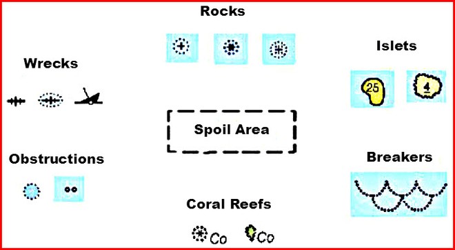
1. 岩石
注意基本的搖滾符號看起來像一個加號。這意味著一塊岩石一直在水面下。看起來像星號的符號表示岩石將在退潮時露出(變得可見)。角落帶有圓點的加號表示岩石位於地表之下,即使在退潮時也是如此。
2. Islets(小島)
小島——被稱為“小島”——在巴哈馬、加勒比海和太平洋很常見。在所有潮汐階段都可以看到被實線包圍的小島。一個數字表示漲潮時的最大高度(或圖表基準)。被波浪形波浪線包圍的小島隨著潮水覆蓋並揭開。在漲潮時,小島將被覆蓋。一個數字表示它在低潮位時露出水面的高度。
3.斷路器
當海洋膨脹遇到只有其高度一到兩倍的海底時,就會形成碎浪。例如,如果兩英尺的海浪穿過底部兩到四英尺深,它就會破裂。
斷路器對任何小型船隻都是危險的,因為它們會導致方向舵或螺旋槳失控。
遠離上圖所示的任何符號。您可能還會看到單獨使用的縮寫“Br”,沒有符號。
4. 珊瑚礁
世界上最受歡迎的巡航場地——巴哈馬、加勒比島嶼和太平洋環礁——也包含一些最危險的水域。仔細研究您的航海圖,並尋找靠近任何岩石或小島符號的“Co”縮寫。
5. 障礙物
在航海或電子海圖顯示上很容易錯過,障礙物可能會損壞螺旋槳、軸和龍骨。許多海圖僅使用縮寫“Obstn”來警告海員。圓圈周圍的點表示表面下潛伏著未知的危險。微小的封閉圓圈可能是殘破的樹樁、舊的打樁殘餘物或淹沒的桿子和柱子。
6. 沉船
魚骨和沈船插圖構成了最常見的沉船符號。沒有圓點的魚骨可以安全航行。製圖師將這些放在海圖上,以警告商業拖網漁船不要拖網,並警告船隻不要拋錨。給被圓點或沉船符號包圍的魚骨留出很大的距離,以免損壞船體。
7. 破壞區
比瘟疫更致命,識別、突出顯示並遠離虛線輪廓,如“破壞區”、“魚港”、“魚陷阱”或“垃圾場”。有沒有想過所有這些舊汽車和卡車、建築材料或垃圾都去哪兒了?現在你知道了!破壞區域從不顯示探測,因為深度一直在變化。
您需要知道的危險縮寫
熟悉帶有或不帶有上述符號的危險縮寫。研究這些,直到您一目了然:
Rk、R 或 Rks – 岩石或岩石
Hk 或 Wk – 綠巨人或沉船
Obstn – 水下障礙物
合作 – 珊瑚
犯規 – 犯規地面
這些額外的縮寫可以在任何危險符號旁邊找到,或者它們可能單獨存在。例如,“Shoal Rep”表示水手在該位置報告了淺水(“Rep”),但尚未對其進行調查。遠離導航圖上由這些縮寫標記的任何區域。
PA - 位置近似
PD – 持懷疑態度
ED——存在懷疑
代表 - 報告
SD——聽起來很可疑
現在您知道如何識別世界上任何航海圖上的七個危險組符號中的任何一個。使用這些圖表導航秘訣為您提供優勢,並在您選擇巡航的任何地方確保您的船員安全無恙。
了解有關海圖符號和縮寫的更多信息。下載免費出版物“海圖 1:海圖符號、縮寫和術語”, 這裡.
擁有 25 年以上經驗的 John Jamieson(約翰船長)向您展示了在全球範圍內更安全航行所需的嚴肅巡航技能。訪問他的網站 www.skippertips.com。訂閱免費且廣受歡迎的每週“約翰船長的每週航行提示”。了解如何即時訪問數百篇航海文章、視頻和電子書!
(來源:https://www.sail-world.com/Australia/Know-these-seven-danger-nautical-chart-symbols/-107197?source=google)
海圖符號和縮寫應用程序 iTunes 應用程序
海圖符號和縮寫應用程序 (谷歌播放商店)
贊助上市