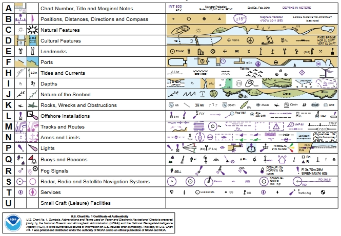
(* source: NOAA – the National Oceanic and Atmospheric Administration (USA), the American scientific and regulatory agency – Symbols, Abbreviations and Terms used on Paper and Electronic Nautical Charts ENCs)
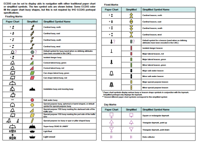
see a full list of symbols used on paper nautical charts (and their digital raster image equivalents) and the corresponding symbols used to portray Electronic Navigational Chart (ENC) data on Electronic Chart Display and Information Systems (ECDIS).
https://www.nauticalcharts.noaa.gov/publications/docs/us-chart-1/ChartNo1.pdf
examples:
April 15, 2019
Prepared in USA Jointly by
Department of Commerce – National Oceanic and Atmospheric Administration
Department of Defense – National Geospatial Intelligence Agency
Symbology for displaying Electronic Navigational Charts (ENCs) on Electronic Chart Display and Information Systems (ECDIS) has been added to U.S. Chart No. 1.
In addition to the ECDIS symbols shown in the traditional lettered sections of U.S. Chart No. 1, there are now several special pages devoted exclusively to providing important details about ECDIS. These pages are distinguished by the ECDIS icon, as shown in the top left corner of this page. The ECDIS pages are also listed in the table of contents in italic type.
One major difference in the use of paper charts and ENCs is the ability of ECDIS to display the same feature differently depending on user settings and other conditions, such as a ship’s draft. An important example is that ECDIS displays wrecks, rocks and other obstructions with their traditional “paper chart” symbols if they are at or deeper than the depth of the safety contour set for the ship. Dangers that are shoaler are portrayed with the unique ECDIS “isolated danger” symbol shown at left. (See the ECDIS Portrayal of Depths page for more information about the ECDIS safety contour.)
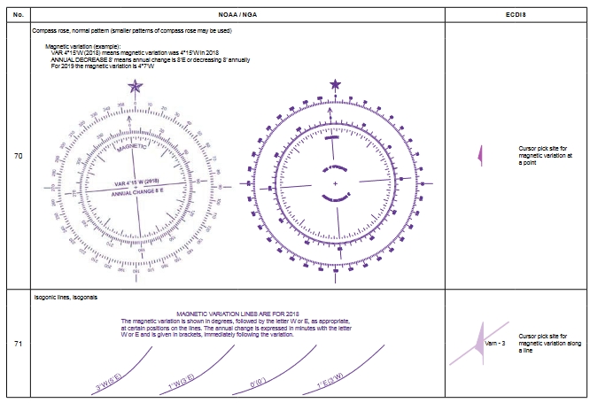
Another advantage that ECDIS provides over paper charts is enabling users to obtain more information about a feature through a “cursor pick.” Some feature attribute values that can be obtained by cursor pick are noted throughout U.S. Chart No. 1. This is especially true if a particular value, such as height, vertical clearance or the like is included in the INT symbol description. The cursor pick icon, shown at left, is used to indicate when a reference to a cursor pick is made.
There are many other attribute values that users may obtain through a cursor pick that are not specifically noted. These include, but are not limited to, the purpose, seasonality, periodicity, status, color, height, type of structure and the visual or radar conspicuousness of features; shape, color or color pattern of buoys; characteristics of lights; category of obstructions and wrecks; radar wave length, radio frequency, communication channel and call signs; the presence of AIS transmitted signals; information regarding pilotage services and many more.
U.S. Chart No. 1 is a handy guide for ECDIS users, but it is no substitute for mandated ECDIS training.
The ECDIS user and developer communities are invited to help improve the presentation of ECDIS symbology and information in U.S. Chart No. 1. Please let NOAA know what additional information you would like to see in the next edition.
Corrections, comments, or questions regarding U.S. Chart No. 1 may be submitted through ASSIST, the NOAA Coast Survey stakeholder engagement and feedback website at: www.nauticalcharts.noaa.gov/customerservice/assist,
or mailed to:
National Ocean Service, NOAA (N/CS2) Attention: U.S. Chart No. 1
1315 East West Highway Silver Spring, MD 20912-3282
SYMBOLS, ABBREVIATIONS AND TERMS
Document Sections and ECDIS Pages
Introduction 5
Schematic Layout 8
Day, Dusk and Night Color Palettes 9
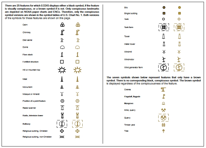
Conspicuous and Non-Conspicuous Features 28
ECDIS Portrayal of Depths 47
Examples of Routing Measures in ECDIS 69
Simplified and Traditional Paper Chart symbols 90
Index of Abbreviations 111
Index 117
Appendix 1, IALA Maritime Buoyage System 128
Symbol Sections
GENERAL
TOPOGRAPHY
HYDROGRAPHY
NAVIGATION AIDS AND SERVICES
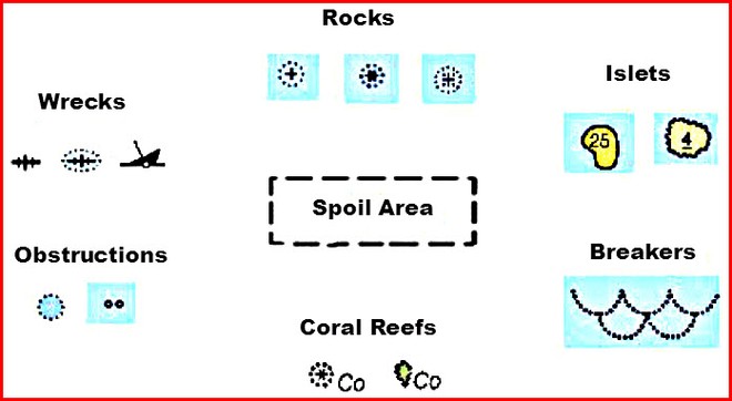
identify in short time the seven vital danger symbols in Marine Charts, these that could rip a hole in your boat’s hull, damage your keel, bend a propeller shaft, mangle a propeller, or cause you to go aground.
There are dozens of danger symbols used on nautical charts today, but here are some of the more common ones. Know these ‘ship killers’ to stay safer on the waters of the world wherever you choose to sail or cruise.
1. Rocks
Note how the basic rock symbol looks like a plus sign. This means a rock that’s beneath the water surface all the time. A symbol that looks like an asterisk means the rock will uncover (become visible) at low tide. A plus sign with dots in the corners means the rock lies just beneath the surface, even at low tide.
2. Islets (small islands)
Small islands–called ‘islets’–are common in the Bahamas, Caribbean, and Pacific. Islets surrounded by a solid line are visible at all tidal stages. A number indicates the maximum height at high tide (or charted datum). Islets surrounded by a wavy, squiggly line cover and uncover with the tide. At higher tides, the islet will be covered. A number indicates its height above water when uncovered at lower tidal stages.
3. Breakers
Breakers form when ocean swell meets a sea bottom that’s only one to two times their height. For example, if a two foot swell travels over a bottom two to four feet deep, it will break.
Breakers are dangerous to any small craft because they can cause loss of rudder or propeller control.
Stay clear of any symbol like that shown in the illustration above. You may also see the abbreviation ‘Br’ used alone without the symbol.
4. Coral Reefs
The world’s most popular cruising grounds–Bahamas, Caribbean islands, and Pacific atolls–also contain some of the most dangerous waters. Study your navigational chart with care and look for the ‘Co’ abbreviation close to any rock or islet symbol.
5. Obstructions
Easy to miss on a nautical or electronic chart display, obstructions can cause damage to propellers, shafts, and keels. Many charts use only an abbreviation ‘Obstn’ to warn mariners. Dots around a circle mean an unknown hazard lurks beneath the surface. Tiny enclosed circles could be broken stumps, old piling remnants, or submerged poles and posts.
6. Wrecks
Fish-bones and sunken-hull illustrations make up the most common wreck symbols. Fish-bones without dots are safe to sail across. Cartographers put these on charts to warn commercial fishing trawlers not to drag nets and to caution ships not to anchor. Give fish-bones surrounded by dots or sunken-hull symbols a wide berth to avoid hull damage.
7. Spoil Area
Deadlier than the plague, identify, highlight, and stay clear of dashed outlines with descriptions like ‘Spoil Area’, ‘Fish Haven’, ‘Fish Traps’, or ‘Dumping Ground’. Ever wonder where all those old cars and trucks, building material, or garbage goes? Now you know! Spoil areas never show soundings because depths change all the time.
Danger Abbreviations You Need to Know
Familiarize yourself with the danger abbreviations used with or without the symbols described above. Study these until you know them at-a-glance:
Rk, R or Rks – Rock or Rocks
Hk or Wk – Hulk or Wreck
Obstn – Submerged Obstruction
Co – Coral
Foul – Foul Ground
These additional abbreviations may be found alongside any danger symbol, or they may stand alone. For instance ‘Shoal Rep’ means that shallow water was reported (‘Rep’) at that position by a mariner, but it has not been surveyed. Stay clear of any area on your navigation chart marked by these abbreviations.
PA – Position Approximate
PD – Position Doubtful
ED – Existence Doubtful
Rep – Reported
SD – Sounding Doubtful
Now you know how to identify any of the seven danger group symbols on any sailing chart in the world. Use these chart navigation secrets to give you the edge and keep your crew safe and sound wherever you choose to cruise.
Learn more about nautical chart symbols and abbreviations. Download the free publication ‘Chart No. 1: Nautical Chart Symbols, Abbreviations and Terms’, here.
John Jamieson (Captain John) with 25+ years of experience shows you the no-nonsense cruising skills you need for safer sailing worldwide. Visit his website at www.skippertips.com. Sign up for the Free, highly popular weekly ‘Captain John’s Sailing Tip-of-the-Week’. Discover how you can gain instant access to hundreds of sailing articles, videos, and e-Books!
(source: https://www.sail-world.com/Australia/Know-these-seven-danger-nautical-chart-symbols/-107197?source=google )
Maritime Navigation Chart Symbols
The golden age of Maritime Maps
The sea chart : the illustrated history of Nautical Maps and navigational charts
NAUTICAL CHART SYMBOLS & ABBREVIATIONS app iTunes app
NAUTICAL CHART SYMBOLS & ABBREVIATIONS app (Google Play store)
Sponsored Listing


Find all top providers of Marine Navigation products & services for safe Maritime Voyage Planning