Testing Sep 2025
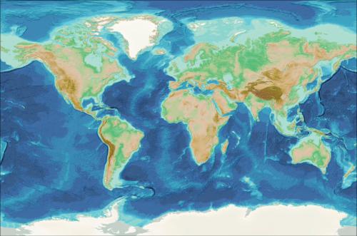
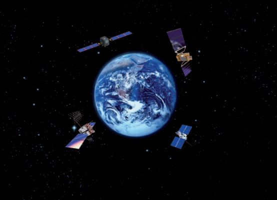
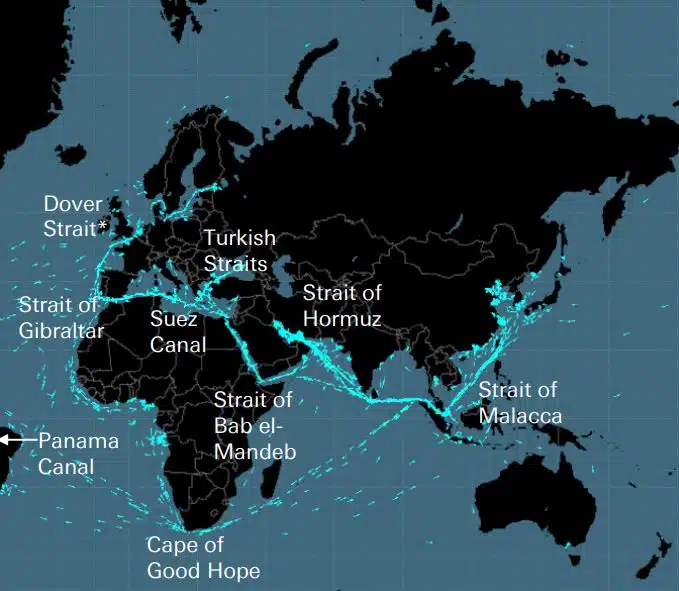
Cables, pipelines, roads, sea straits, air routes and satellites form the fragile network on which the global economy is built. These are invisible networks of enormous importance to the global supply chain and modern life, which, however, are only remembered when a war like the one in Ukraine or Israel threatens one of these strategic […]
DEEPSEA: next-generation voyage optimisation powered by Artificial Intelligence (AI) Use Artificial Intelligence (AI) Performance Routing to instantly accelerate your fleet’s decarbonisation trajectory, and decrease fuel costs. Performance Routing will make a major, quantifiable impact on your fleet’s fuel consumption and CII today, high–impact results from day one. “DeepSea Vessel Voyage Optimisation AI Solution reduces emissions, […]
World's most famous Luxurious Marinas: Which are the most luxurious and popular marinas worldwide? Portofino, Monaco, St. Tropez, Ibiza, St. Barts. One of the first images that comes to mind when we think of these places are their iconic marinas. Dignitaries, powerful people of wealth, glamorous Hollywood stars and all those who have made yachting […]
Fishing is changing for the good of the Earth - advanced bio-based plastic solutions (By Tassoula Eptakili - www.kathimerini.gr) Almost 12 million tons of plastic waste end up in the world's oceans every year. Sometimes they travel in the water, creating huge underwater garbage dumps, and sometimes they come ashore. The effects of mindless consumption […]
Google - Data Centers Through 2022, Google has strengthened its commitment in Greece to accelerate sustainable and inclusive development and digital transformation, further intensifying its substantial support to the country. With strategic initiatives, and with a focus on people, the technology company opened a new important chapter in Greece with the announcement of the creation […]
Lloyd’s List’s One Hundred People, ranking influence and power within shipping Individual actions still matter in shipping, even as shipowners’ power is waning. Yet this year’s defining moment has come from the EU, which has overtaken the IMO as the most influential force in the industry, by taking tangible action to address climate change IT […]
UKHO announced intention to end Paper Nautical Chart production (26 July 2022) (source: UK Hydrographic Office) The UK Hydrographic Office (UKHO) has announced on 26 July 2022 its intention to develop options for the withdrawal from global paper nautical chart production by late 2026 to increase focus on its digital navigation products and services. ("UKHO […]
Ever since people started building complicated things, they realized that there was a need for a measurement system . Originally the basis was the human body. Revolutionary France was to produce what evolved into the definitive International System of Units (International Measurement System) The Egyptians used cubits that were about 52,4 centimeters , but because […]
Arcadia Shipmanagement’s Aegean Myth was recognized by DNV as the first verified SEEMP III vessel Classification society DNV presented Arcadia Shipmanagement Co Ltd with a certificate recognizing their vessel Aegean Myth as the first ship globally to have a SEEMP III manual. The Ship Operational Carbon Intensity Plan or SEEMP Part III, is part of […]
From August 2022, the flying dolphins of Hellenic Seaways, which carried dozens, if not hundreds of millions of Greek and foreign passengers in Argosaronicos gulf over the past five decades, will go down in history. Associated in the perception of most as noisy but fast vehicles for summer and not only escapes, mainly in Argosaronicos, […]
(Marine Shipping Glossary terms are offered by Hellenic Shipping News) press CTRL + F in your web browser to pop up the Search Bar and type the term you want to find... Maritime Dictionary app in Google Play Maritime Dictionary App Marine (app) in google Play Shipping Dictionary (app) in Google Play Naval Terms Dictionary […]
Chart Corrections & Updates Old, non updated (since even few weeks) Nautical Charts should never be used for maritime navigation and voyage planning. The characteristics of a river, in particular, portrayed on a marine chart tends to change continuously, and artificial navigational aids at sea or shores may be altered at any time. As a […]
NOAA's Nautical Paper Charts (Raster Nautical Charts: both paper and digital Raster Charts) will soon not be produced any more (by 2025) On April 13, the US federal government's National Oceanic & Atmospheric Administration (NOAA) announced it will soon stop printing traditional lithographic (paper) nautical charts - while other forms of nautical charts, such as […]
Web Map services (comparison) Most popular Web Map services Google Maps Bing Maps MapQuest OpenStreetMap Here WeGo Apple Maps Yandex Maps Comparison list Feature Google Maps Bing Maps MapQuest OpenStreetMap Here WeGo Apple Maps Yandex Maps License Proprietary Proprietary Proprietary ODbL Proprietary Proprietary Proprietary Availability Full extra functionality Australia, Canada, China, France, Germany, Israel, Italy, […]
A catalog of free (not necessarily Open Source) Satellite Navigation (or "GPS") software for a wide range of devices. (Navigation software with free maps - often uses maps from OpenStreetMap project) Satellite Navigation Software- Non-free maps Name Company Type of device[5] Operating system 3rd-party GPS-able?[6] Software with maps? Follows streets? Open-source? Remarks Aqua Map[29] GEC […]
what are the abbreviations used in Nautical Charts (Admiralty Charts / Maritime Charts) Bottom Characteristics and Abbreviations Nouns Source Chart Noun Abbreviation Abbreviation Boulders Blds Blds Clay Cl Cy Coral Co Co Coralhead Cl Hd Cl Hd Gravel G G Grass Grs Grs Mud M M […]
Filipinos: major source of Seafarers for the global maritime sector - One third of the world's seafarers are Filipinos. In the 1970s, the number of seafarers in traditional maritime countries dropped, resulting in a transfer of supply to countries such as India, China, and the Philippines. The Philippines has developed to become a significant producer […]
A sophisticated new portal for nautical charts and publications has been launched that has no subscription or minimum contract term, and free updates and corrections. OpenC247.com responds to the growing demand for digital technologies in the maritime sector. The soft launch of the portal has attracted more than 150 registered users, from captains of super […]
European Digital Twin of the Ocean (European DTO) This tool will model the ocean and provide knowledge and understanding of the past and present and will create credible predictions of the ocean's future health. The ILIAD consortium will develop virtual representations of the sea that will integrate earth observing, modelling and digital infrastructures to provide […]
What is the Differences between VECTOR and RASTER Graphics? (right below its treated the difference Raster/Vector in regards to graphics - look further below for the difference between Vector Nautical Charts (VNC) and Raster Nautical Charts (RNC)) There is some confusion to many people when it comes to the differences between vector and raster graphics. […]
(* source: www.sailingissues.com - by Diederik Willemsen) Marine Navigation courses (FREE) Find advanced online course on marine navigation for offshore sailing. All though nowadays most sailors rely on maritime navigation and positioning equipment like the use of GPS / Galileo / GLONASS and Radars to navigate, by navigating by yourself is a lot more fun, Learn navigation to sail […]
(* source: NOAA - the National Oceanic and Atmospheric Administration (USA), the American scientific and regulatory agency - Symbols, Abbreviations and Terms used on Paper and Electronic Nautical Charts ENCs) Paper and Electronic Navigational Charts: Symbols, Abbreviations and Terms used on Marine Navigation Charts see a full list of symbols used on paper nautical charts […]
GLOSSARY of Nautical Charts, terms & abbreviations used in the maritime industry (* source: NOAA - the National Oceanic and Atmospheric Administration (USA), the American scientific and regulatory agency) An authoritative source for terms used in cartography (mapping), marine charting, and geodesy used in the nautical charting program. Terms and definitions are of specific cartographic […]
Find all top providers of Marine Navigation products & services for safe Maritime Voyage Planning