Bottom Characteristics and Abbreviations
| Nouns | Source | Chart | |
| Noun | Abbreviation | Abbreviation | |
| Boulders | Blds | Blds | |
| Clay | Cl | Cy | |
| Coral | Co | Co | |
| Coralhead | Cl Hd | Cl Hd | |
| Gravel | G | G | |
| Grass | Grs | Grs | |
| Mud | M | M | |
| Ooze | Oz | Oz | |
| Pebbles | P | P | |
| Sand | S | S | |
| Shells | Sh | Sh | |
| Shingle | Sn | Sn | |
| Silt | Silt | S i | |
| Stones | St | St | |
| Seaweed | Wd | Wd | |
| Adjectives | Adjective Broken Coarse Dark Fine Gritty Hard Large Light Rocky Small Soft Speckled Sticky | Source Abbreviation brk crs dk fne gty hrd lrg lt rky sml sft spk stk | Chart Abbreviation bk c dk f gty h lrg lt rky sml so spk sy |
| Colors | Color Black Blue Brown Gray Green Orange Red White Violet Yellow | Abbreviation bl bu br gy gn or rd wh vi yl |
SOURCE: Nautical Chart Manual
(by the National Oceanic and Atmospheric Administration (NOAA) – National Ocean Service)
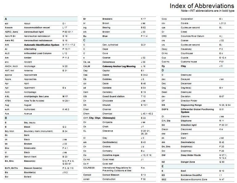
INDEX OF ABBREVIATIONS
(Section V of Chart No. 1)
Abbreviation …….. Meaning…………………………… Symbol
Index of Abbreviations
(Note – INT abbreviations are in bold type)
| A | Br | Breakers | K 17 | Corp | Corporation | E v | ||
| abt About | D i | br | Brown | J az | cov | Covers | L 21.2 | |
| Accom Accommodation vessel | L 17 | brg | Bearing | B 62 | cps | Cycles per second | B j | |
| AERO, Aero Aeronautical light | P 60–61.1 | brk | Broken | J 33 | Cr | Creek |
| Aero R Bn | Aeronautical radiobeacon | S 16 | CRD | Columbia River Datum | H j | |||
| Aero RC AIS | Aeronautical radiobeacon $XWRPDWiF ,GHQWifiFDWiRQ 6\VWHP | S 16 S 17.1–17.2 | Bu C C | Blue Can, cylindrical | P 11.4 Q 21 | crs c/s | Coarse Cycles per second | J 32 B j |
| Al | Alternating | P 10.11 | C | Cape | Cswy | Causeway | F 3 | |
| ALC | Articulated Load Column | L 12 | C | Cove | Ct Ho | Courthouse | E o |
| Am | Amber | P 11.8 | c | Coarse | J 32 | Cup | Cupola | E 10.4 | |
| anc | Ancient | Ca, ca | Calcareous | J 38 | Cus Ho | Customs house | F 61 | ||
| ANCH, Anch | Anchorage | N 20 | CALM | &DWHQDU\ $QFKRU /HJ 0RRUiQJ | L 16 | &\ | &OD\ | J 3 | |
| ANT, Ant | Antenna | E 31 | Cap | Capitol | E t | D | |||
| approx | Approximate | Cas | Castle | E 34.2 | D | Destroyed | |||
| Apprs | Approaches | Cb | Cobbles | J 8 | dec | Decayed | J an | ||
| Apr | April | cbl | Cable | B 46 | Dec | December | |||
| Apt | Apartment | E s | cd | Candela | B 54 | Deg | Degree(s) | B n | |
| Arch | Archipelago | Cem | Cemetery | E 19 | Destr | Destroyed | |||
| ASL | Archipelagic Sea Lane | M 17 | CG | Coast Guard station | T 10 | dev | Deviation | B 67 | |
| ATBA | Area To Be Avoided | M 29.1 | Ch | Chocolate | J ba | DF | Direction Finder | ||
| Aug | August | Ch | Church | E 10.1 | DG | Degaussing Range | N 25, Q 54 | ||
| auth | Authorized | K 46.2 | Chan | Channel | DGPS | Differential Global Positioning | S 51 | ||
| Ave | Avenue | Chem | Chemical |
L 40.1–40.2
CHY, &K\, &K\V &KiPQH\(V) E 22
B Bay, bayou
Cir Ck
Cirripedia Chalk
J ae J f
| Bdy Mon Boundary mark (monument) B 24 Bk Bank bk Black J as bk Broken J 33 Bkw Breakwater F 4.1 bl Black J as BM Bench Mark B 23 |
| 6\VWHP Di Diatoms J aa DIA, Dia Diaphone R 11 Dir Direction light P 30–31 |
CL Clearance D 20–21, 26, 28
Discol dist
Discolored K e
Distant
Cl Clay J 3 dk Dark J bd
cm Centimeter(s) B 43 dm Decimeter(s) B 42
Cn Cinders J p Dn, Dns Dolphin(s) F 20
Co Company E u Dol Dolphin(s) F 20
| DW Deep Water Route M 27.1, DZ Danger Zone N 12.4 Q 50 E E East B 10 |
Co Coralline Algae J 10, K 16
Co Hd Coral Head J i
Bn, Bns
Beacon(s)
M 2, P 4–5,
BnTr, BnTrs Bo
Bol
Beacon tower(s) Boulder(s) Bollard
Q 80–81
P 3, Q 110
J 9.2
Co rf COLREGS
Consol
Coral reef
International Regulations for Preventing Collisions at Sea
Consol Beacon
N a
S 13 ED
Existence Doubtful I 1
constr Construction F 32 EEZ Exclusive Economic Zone N 47
FISH Fishing N 21 H Helicopter T 1.4 Jul July
| Fl | Flashing | P 10.4 | h | Hard | J 39 | Jun | June | ||
| fl Fla | Flood Flare stack | H q L 11 | h HAT | Hour Highest Astronomical Tide | B 49 H 3 | K K | Kelp | J u | |
| fl\ | Flinty | J ao | Hbr Mr | Harbormaster | F 60 | kc | Kilocycle | B k | |
| fm, fms | Fathom(s) | B 48 | HHW | Higher High Water | H b | kHz | Kilohertz | B h | |
| fne | Fine | J 30 | Hk | Hulk | F 34, K 20–21 | km | Kilometer(s) | B 40 | |
| Fog Det Lt | Fog detector light | P 62 | Ho | House | kn | Knot(s) | B 52 | ||
| Fog Sig | Fog Signal | R 1 | hor | +RUi]RQWDOO\ GiVSRVHG | P 15 | L | |||
| FP | Flagpole | E 27 | Hor CL | Horizontal clearance | D 21 | L | Lake, loch, lough | ||
| FPSO | Floating Production, Storage DQG 2IflRDGiQJ 9HVVHO | L 17 | Hosp hr | Hospital Hour | E g, F 62.2 B 49 | L Fl La | /RQJ-flDVKiQJ Lava | P 10.5 J l | |
| Fr Fs, FS Fsh stks | Foraminifera Flagstaff Fishing stakes | J y E 27 K 44.1 | hrd ht HW | Hard Height High Water | J 39 H p H a | Lag LANBY | Lagoon Large Automatic Navigational %XR\ | Pf | |
| FT, ft | Foot, Feet | B 47, D 20 | HWF&C | High Water Full & Change | H h | LASH | Lighter Aboard Ship | ||
| Fu | Fucus | J af | Hz | Hertz | B g | LAT | Lowest Astronomical Tide | H 2 | |
| G | Lat | Latitude | B 1 | ||||||
| G | Gravel | J 6 | IALA | International Association of | Q 130 | Ldg | Landing | F 17 | |
| G | Green | P 11.3, Q 2 | Lighthouse Authorities* | Ldg | Leading Lights | P 20.3 |
G Gulf IHO International Hydrographic Le Ledge
GAB, Gab Gable E i
GCLWD Gulf Coast Low Water Datum H k Gl Globigerina J z
Organization
illum Illuminated P 63
IMO International Maritime Organization
LLW Lower Low Water H e
Lndg Landing for boats F 17
LNG /iTXifiHG 1DWXUDO *DV
*Now known as the International Association of Marine Aids to Navigation and Lighthouse Authorities. The organization, formerly called the International Association of Lighthouse Authorities/Association Internationale de Signalisation Maritime (IALA/AISM), continues to use IALA as an abbreviation for its full name.
| Lt, Lt(s) Light(s) P 1 MR Marine Reserve N 22 P Pebbles J 7 Ltd Limited E r MRCC Maritime Rescue and P Pillar Q 23 LW LWD LWF&C M M Low Water Low Water Datum Low Water Full and Change 0XG, PXGG\ H c H d H i J 2 Ms MSL Mt Mth Coordination Center Mussels Mean Sea Level Mountain, Mount Mouth J s H 6 (P) PA Pass Pav PD Preliminary (NTM) Position approximate Passage, Pass Pavilion Position doubtful B 7 E p B 8 MTL N Mean Tide Level H 1 M m Nautical mile(s) Medium (in relation to sand) B 45 J 31 Pk PLT STA Peak Pilot station T3 m m Ma Meter(s) Minute(s) of time Mattes B 41 B 50 J ag N N NE North Nun Northeast B 9 Q 20 B 13 Pm PO Po Pumice 3RVW RIfiFH Polyzoa J m F 63 J ad mag Magnetic B 61 NGA National Geospatial-Intelligence Agency pos, posn Position Magz Magazine E l NM Nautical miles(s) B 45 Post Off 3RVW RIfiFH F 63 Maintd Maintained P 65 NMi Nautical mile(s) B 45 Priv, priv Private P 65, Q 70 man 0DQXDOO\ DFWiYDWHG P 56, R 2 No Number N 12.2 Prod well Production well L 20 Mar March NOAA National Oceanic and Atmospheric PROHIB Prohibited N 2.2 Mc Megacycles B l Administration PSSA 3DUWiFXODUO\ 6HQViWiYH 6HD $UHD N 22 Mds Madrepores J j NOS National Ocean Service Pt Pteropods J ac MHHW Mean Higher High Water H 13 Nov November 3\O 3\ORQ D 26 MHLW Mean Higher Low Water H 14 Np Neap tide H 17 Q MHW Mean High Water H 5 NT Net Tonnage Q Quick P 10.6 MHWN Mean High Water Neaps H 11 NTM Notice to Mariners QTG Service producing DF signals S 15 MHWS Mean High Water Springs H9 NW Northwest B 15 Quar Quarantine F e Mi min Nautical mile(s) Minimum B 45 K 46.2 NWS SIG STA National Weather Service signal station T 29 Qz R Quartz J g min Mk Minute(s) of time Mark B 50 Q 101 O Obs Spot R Coast radio station providing QTC service S 15 Observation spot B 21 Ml Marl J c OBSC, Obscd Obscured P 43 R Radio Station S 15 MLHW MLLW Mean Lower High Water Mean Lower Low Water H 15 H 12 Obstn Oc Obstruction Occulting K41 P 10.2 R R, r Red 5RFN, 5RFN\ P 11.2 J 9.1, K b |
Example icons of abbreviations and symbols that are used in Marine Charts below:
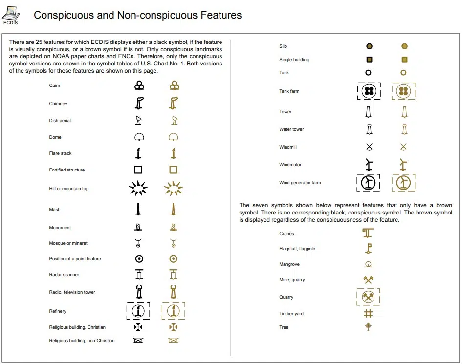
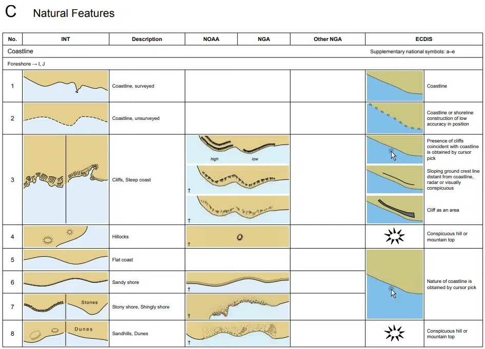

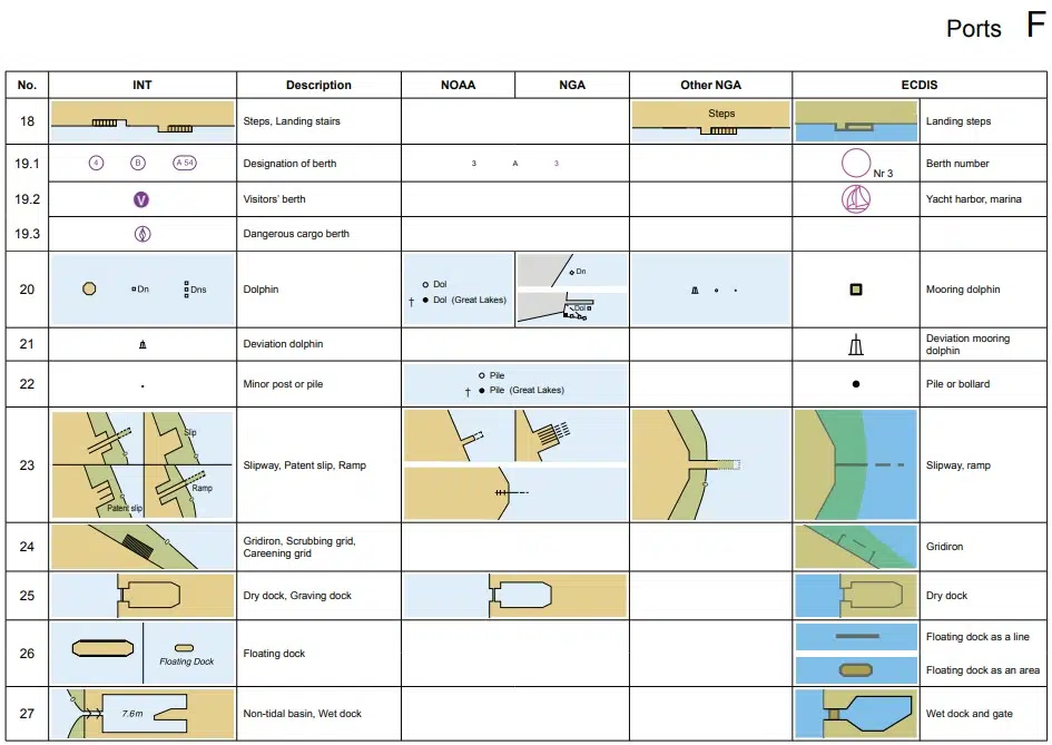
see the full document with all the Abbreviations & Symbols used on Nautical Charts at: https://www.nauticalcharts.noaa.gov/publications/docs/us-chart-1/ChartNo1.pdf
Sponsored Listing


Find all top providers of Marine Navigation products & services for safe Maritime Voyage Planning