4月13日,美國聯邦政府的國家海洋與大氣管理局(美國國家海洋和大氣管理局) 宣布將很快停止打印傳統的平版(紙質)海圖——而其他形式的海圖,例如 按需打印圖表 和 電子製圖 系統版本(ENC) 將繼續生產。
海圖提供 水文, 航海的 和 地形 向全世界的水手提供信息。
海圖上提供的信息量取決於海圖的比例。比例越大,海圖中提供的信息就越多。比例為 1:30.000 的大型海圖提供了有關特定海域的非常詳細的信息,並且是海員首選的航路規劃。另一方面,小比例的海圖,例如 1:2.000.000 的海圖,提供的信息很少、不詳細,最適合一般的海上航線規劃。最大規模的海圖經常更新: 圖表更正.這只是盡可能使用大型海圖的眾多原因之一。
概括地說,“海圖報廢”是什麼意思?
2020年以來,國家海洋和大氣管理局(美國國家海洋和大氣管理局) 在美國,已開始逐步淘汰柵格圖表(紙質圖表)。但這包括光柵海圖和小冊子海圖的數字圖像。所以, 到 2025 年 1 月,美國國家海洋和大氣局 將不再生產光柵海圖產品(包括:紙質海圖,即光柵海圖的印刷品,以及數字光柵海圖)。這也意味著現有的 5 位光柵海圖編號將被淘汰。現有的按需打印紙質光柵海圖也將消失。僅 2025 年後 數字海圖 (電子海圖 – ENC) 將產生。
“海圖報廢”的時間表是什麼?
隨著重新計劃過程的推進,將不會為新的更大比例尺的 ENC 覆蓋範圍開發等效的光柵圖。 NOAA 光柵海圖將在 2020 年至 2023 年之間逐步淘汰。當海圖被標記為取消時,按需打印版本會更新一個符號,表明它是海圖的最後一個版本,並將停止使用 6到 12 個月後。 NOAA“最新版本列表”網頁和 當地海員通告 (NtM) 將根據圖表取消的最終通知進行更新。
因此,很快,Mariners 將無法購買 NOAA 的航海紙質海圖。但還有另一種選擇:從數字版航海圖打印您自己的最新備份航海紙圖(矢量海圖 VNC) – 而且價格只是其中的一小部分。
“航海紙圖”的未來是什麼?
NOAA 將繼續推廣使用基於 ENC 數據的紙質海圖產品,無論是通過 NOAA 自定義圖表 在線工具或通過提供基於 ENC 的圖表產品的第三方商業供應商。 NOAA 自定義圖表 (NCC) 是仍在開發中的原型,可在線獲取。用戶可以自定義定制海圖的比例尺和紙張大小,以及居中位置。在那之後, NCC 創建一個地理空間參考的便攜式文檔格式,並在單獨的 PDF格式 頁。然後可以下載、查看和打印這些 PDF。訪問 https://devgis.charttools.noaa.gov/pod 試用 NCC 原型。
會發生什麼 到 本地海員服務通知 提供?
美國海岸警衛隊的 當地水手通告 (LNM) 是傳達有關海上航行輔助信息、航行風險和其他海員基本信息的主要方式。由於這些通知,海員們被允許在紙質海圖上進行手動調整。一旦 NOAA 停止製作光柵紙質海圖,就不需要在給海員的地方通知中的第 IV 節“海圖更正”。目前尚不清楚如何通知 NOAA 自定義海圖的更新。由於傳統海圖和海圖編號在不久的將來在美國將不復存在,因此現在引用海圖編號的地方海員通告的其他部分將不得不依賴其他通信方法。或許,描繪入口、海灣和港灣而不是海圖編號將成為新標準。
——
光柵圖即將推出,新的矢量海圖(電子海圖 - ENC)也即將推出。
根據 2019 年 11 月發布的時間表,到 2025 年 1 月,NOAA 預計將逐步淘汰所有柵格圖表產品,轉而使用矢量圖。NOAA 兩年多前製定了國家製圖計劃草案,其中包括逐步淘汰柵格圖表的意圖。經過公眾意見徵詢期後,NOAA 於 2017 年 11 月發布了其國家製圖計劃,其中重點關注矢量圖產品。這兩份 NOAA 出版物共同描述了海圖的未來。
圖表的未來是一個廣泛的話題。另一方面,NOAA 逐步淘汰所有光柵產品的計劃引起了廣泛關注。
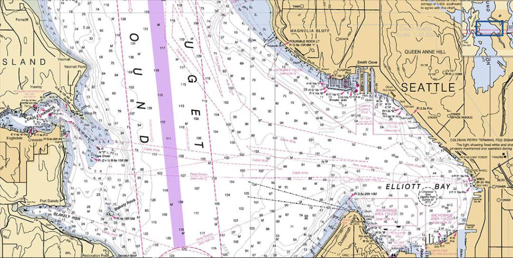
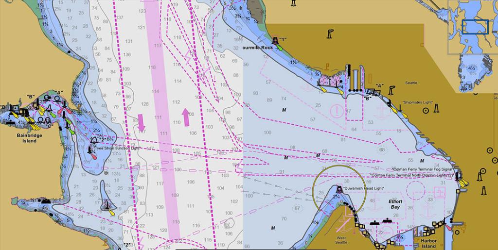
目前,划船者可以在光柵導航圖 (RNC) 和矢量電子導航圖 (VEC) (ENC) 之間進行選擇。製圖師開發光柵圖,它是傳統海圖的數字或紙質圖像。構成圖表的符號、線條和色調由電子圖像中的彩色像素行或墨點組成。矢量圖是特徵的數字表示,存儲為緯度和經度坐標對(與像素矩陣相反)。每個特徵的記錄都對其顏色、形式、用途和其他特徵進行了更詳細的描述。
紙質航海圖、光柵航海圖和小冊子海圖都是 NOAA 光柵海圖產品的示例。 NOAA 唯一的航海矢量產品是電子航海圖。 NOAA 並不是唯一創建光柵圖的機構。對於內陸水域,美國陸軍工程兵團發佈光柵圖,而加拿大水文局為加拿大水域製作光柵圖和矢量圖。
為什麼紙質海圖(光柵海圖)會消失?
光柵海圖和光柵海圖電子圖像(RNC)已經存在很長時間了。 180 多年前,海岸調查局準備並出版了第一張紙質海圖。得益於新的方法、設備和技術,改進的矢量或電子海圖 (ENC) 現在成為可能,這是 NOAA 未來幾年的目標。用於顯示 ENC 的數據庫於 1993 年首次生成,按照今天的標準,該數據庫已過時,需要更新。值得注意的是,美國政府正在採取積極措施升級數據庫,以便在矢量圖上顯示更多信息。雖然陸軍工程兵團、加拿大水文服務部和其他外國政府繼續提供光柵圖,但 NOAA 已確定維護兩種基本服務於相同目的的海圖產品既費時又不划算;相反,NOAA 寧願將精力集中在製作具有新優勢的更詳細的 ENC 海圖上。這個想法是 ENC 是傳達更新導航信息的最有效方式,而光柵海圖產品落後於其 ENC 對應產品。
光柵(紙質)海圖與數字(矢量)海圖的優缺點是什麼
由製圖師生成的光柵圖的視覺吸引力在划船者中越來越受歡迎。我們喜歡沿海岸線展示山脈和其他陸地特徵的高程圖,以及柵格地圖更詳細的海深統計數據。放大柵格圖表時存在限制,因為柵格圖表的電子圖像存儲為彩色像素的行和列。放大光柵圖時,圖像會模糊並丟失細節。另一方面,ENC 允許無限縮放以達到所需的細節水平。矢量圖數據庫不是像素矩陣,而是將特徵存儲為緯度和經度坐標對。雖然矢量圖沒有光柵圖那樣的視覺吸引力,但 ENC 和矢量圖有著光明的未來。
NOAA 將在幾年內將所有 ENC 重新安排為一致的矩形網格配置。因此,將提供超過 9,000 個 ENC(也稱為單元)的產品套件;這些單元中的許多單元將以比它們將取代的 ENC 更高的規模聚集,從而提供更廣泛的覆蓋範圍。正在編制新的、更大規模的重新設計的 ENC 海圖,以提供額外的深度和海岸線數據。新的 S-100 ENC 數據標準將為海員提供有關潮差和水流的準確信息。
相同或相似圖表比例的相鄰單元格上的數據邊緣匹配將是另一個 ENC 功能增強。以前,每個 ENC 單元都保存在自己的數據庫中,這使得重新設計 ENC 成為問題。現在,所有 ENC 數據都將存儲在一個統一的數據庫中,稱為航海信息系統 (NIS)。以前,ENC 使用 131 種不同的尺度進行編譯;在重組過程中,這將減少到20個或更少的標準化規模。這些標準化秤將符合國際海事組織 (IMO) 的 ENC 秤,這是新 S-100 系列產品所需的。
目標是提供一個網格化框架,可以根據地理位置輕鬆分割或擴展,同時提高一致性和詳細程度。
——
2020 年 8 月 28 日——國際水文組織和航海製圖工作組對當前和未來海洋環境中有關紙質海圖的問題和建議的概述。
這 航海製圖工作組 NCWG (國際海道測量組織 IHO)準備了這份與“紙質海圖的未來”。本報告並非對全球紙質海圖製作、分發和使用實踐的詳盡研究。許多部分都是從一個或幾個水道測量局的角度介紹的。儘管這些經歷對許多人來說都是典型的 水文辦公室,其他辦事處的條件和做法可能有所不同。一項調查由 工作組 為所有人提供了機會 國際水文學組織 會員國分享他們的個人情況。本報告介紹了與紙質海圖相關的重要問題,這些問題可能需要 IHO、各個水文辦公室、監管機構、海員和其他利益相關者以不同的方式思考紙質海圖,並採取適當的行動為紙質海圖的未來做準備。該報告提出了進一步考慮和可能製定額外的 IHO 航海製圖指南的建議。
銷售和使用 紙質海圖下降 從 2008 年到 2018 年減少了大約一半,而使用 電子海圖 (ENC) 同期增長了約七倍。與越來越多地使用 ENC. 水文辦公室 現在正在探索減少紙質海圖製作負擔的不同方法,例如減少其紙質/光柵海圖產品套件中的海圖數量,或開發直接從 ENC 數據創建光柵海圖產品的方法。還正在努力利用 ENC 或 ENC 衍生產品,對海員和休閒划船者更具吸引力。
使用紙質和電子海圖——相關規定: 國際公約 海上人命安全 (SOLAS),第五章,第 19 條,“船載導航系統和設備的運輸要求”,規定“所有船舶,不論大小,均應有海圖和航海出版物,以規劃和顯示船舶預定航次的航線,並繪製並監控整個航程中的位置。一種電子海圖顯示和信息系統(電子信息系統)亦被接納為符合本項的航圖運輸規定。”第 19 條還規定,“一張適當的紙質海圖 [仍然] 可用作 ECDIS 的備份安排。”
2018 年 7 月,國際海事組織 (IMO) 強制要求大多數國際航行的商船配備電子海圖顯示和信息系統 (ECDIS) 的要求全面生效。一些國家海事當局現在還允許國內航行的商船完全使用 ENC 導航。值得注意的是,在對 NCWG 調查作出答复的 48 個成員國中,只有 7 個表示只有紙質海圖才能滿足運輸要求。大多數人表示可以接受 ENC 或紙質海圖。許多休閒划船者也接受了電子海圖的使用。儘管這些用戶中的許多人仍然保留一些紙質海圖作為備份或遵守當地法規,但紙質海圖的銷量在過去十年中有所減少,而 ENC 的使用卻顯著增加。但是,這因國家/地區而異。
這 聯合國海洋法公約 (聯合國海洋法公約) 定義了各種海洋界限,沿海國在這些界限上享有某些權利,例如 領海、毗連區、專屬經濟區, 和 陸架.公約規定需要在海圖上公佈這些限制並交存聯合國,但公約沒有具體說明海圖是否 紙質或電子.現在可能是更多國家開始報告其對 ENC 的海上限制的時候了。這也將支持更多地使用 GIS 技術來共享信息和識別不一致之處。
海圖用戶:除了傳統的海圖用戶,例如國際或國內航行的專業海員;以及在湖泊、河流、海灣和沿海水域航行的休閒划船者,還有許多其他海圖數據用戶更難以分類或說明。事實上,甚至很難確定歸因於專業海員和休閒划船者的海圖銷售比例,更不用說其他出於各種目的使用海圖的人了,例如船舶交通安全、國防、環境規劃、海事和與冰相關的劃界、旅遊規劃、漁業管理等非航海用途。
單一來源圖表生產數據庫: 一些水文辦公室已經過渡到一個單一的海圖製作數據庫,該數據庫用於製作 ENC 和紙質海圖產品。這有時伴隨著所需生產技能的相對比例的轉變。更多的製圖師參與數據庫操作、編譯和 ENC 編碼工作,而較少支持紙質海圖產品的生成和分發。
Chart Product Suite 更改:ENC 數據可能需要一些時間來進行初始數據編碼,但可以輕鬆地從生產數據庫中發布,而無需額外的工作。紙質海圖產品通常需要額外的手動製圖“整理”操作才能發布。一些水道測量辦公室也正在取消一些紙質海圖,同時維護相應的 ENC 或創建新的、更大比例尺的 ENC 覆蓋範圍而不創建等效的紙質海圖。一些水道測量辦公室正計劃最終取消其所有光柵海圖產品。通過在船上引入更大的顯示屏,可以減輕電子導航系統在提供大面積“大圖”概覽方面的困難。與此同時,有一些證據表明,對小比例尺總圖和航海圖的需求可能會持續存在。所有比例尺的紙質海圖銷量都在下降,但較小比例尺的海圖銷量下降速度較慢。
國際 (INT) 圖表:IHO 國際 (INT) 海圖概念的初衷是促進提供適用於國際航運並始終符合國際規範的海圖。 INT 海圖還使 IHO 成員國能夠在本國水域以外提供海圖,只需稍作修改即可打印傳真海圖。然而,越來越多的水道測量辦公室現在不願意製作 INT 海圖和維護 INT 方案,只要它們已經按照 S-4 規範製作,他們更願意採用他們的國家海圖來代替 INT 海圖。一個圖表區域與另一個圖表區域的情況非常不同,INT 圖表概念本身的未來現在受到質疑,特別是考慮到更大的 SOLAS 船隻現在需要導航 電子信息系統 和 ENC.
按需打印: 幾個水文局現在正在使用傳統印刷(通常是膠印)和“按需印刷”(POD)方法的混合。許多人已經完全過渡到 POD。傳統的打印方法需要存儲大量預先打印的圖表,這些圖表在出售時需要進行更正。對於在新編號的海圖版本之間對 POD 版本的海圖進行重要(通知水手)更正的水文辦公室,POD 流程會在每個用戶訂購一張時打印並立即分發完全更新的海圖——即使是在新海圖的中間圖表版本。 POD 使海圖分發更加高效,但它仍然與傳統的紙質海圖製作相關聯。按需圖表(或產品)具有直接從數據庫創建定製紙質圖表的潛力。
從 ENC 數據打印紙質圖表 “按需圖表”:一些水文局正在開發一種替代傳統紙質海圖製作的方法,使用戶能夠指定他們自己定制的紙質海圖產品的範圍、比例和紙張尺寸。任何“按需圖表”產品看起來都必然與標準圖表不同。主要區別在於圖表佈局看起來更像是許多國家地形圖系列中使用的標準化設計。一些方法目前使用 IHO S-52 表示庫(指定用於 ECDIS 的符號系統)從 ENC 數據創建可打印的柵格產品,因為 S-52 中已經有將 ENC 特徵/屬性值映射到標準的規則符號學。還努力提供更傳統的(基於 IHO S-4)渲染,但有一些困難需要克服,如下一節所述。
使用 S-57 屬性數據描繪光柵圖: 已經做出了一些努力來使用 ENC 或其他 S-57 屬性數據在柵格圖表產品上自動應用 IHO S-4(也稱為 INT1)符號系統和圖例,但目前還沒有一種通用的方法來執行此過程。目前,這些工作中的每一項都必須由各個水文辦公室進行。可以促進共享資源以加快這一進程的一些有用的未來研究和開發工作可能包括:
• 為 S-4 符號創建精確的符號形狀、大小和顏色規範(工程圖紙)。
• 為 S-4 紙質海圖符號創建一個命名約定和一個標準的數字符號圖形文件庫,可能採用與新 S-101 ENC 產品符號相同的可縮放矢量圖形 (SVG) 格式。
• 修改 S-52 查找表以指向 S-4 符號目錄中列舉的紙質海圖符號。
這也可以使 S-101 開發工作更容易使用更多類似紙質圖表的符號來描繪 ENC 電子信息系統 用戶已表現出偏好。 S-101 ENC 產品規範的持續開發還應記住,除了支持在 ECDIS 中描繪 ENC 數據外,還應考慮如何優化 ENC 編碼以支持紙質海圖的符號化和打印。 ENC 編碼數據。
紙質海圖的備份使用: 一些水文局正在考慮開發簡化版的標準紙質海圖,以減少海圖“整理”的需要。這些簡化的產品將主要用作電子導航系統的備份。雖然沒有強烈的支持 工作組 或 IHO 目前的一般成員國,IHO 可能會發揮作用,幫助制定規範,或至少指導方針,用於簡化光柵海圖產品,以便在未來某個時候進行備份。
光柵導航圖的製作: 光柵海圖 (RNC)——傳統紙質海圖的數字圖像——曾經被用作 ECDIS 中不存在 ENC 的區域的替代數據源。完整的 ENC 覆蓋範圍現已廣泛可用,因此 ECDIS 中對 RNC 數據的需求不再是水文辦公室需要考慮的重要因素。一些水文辦公室完全停止了 RNC 生產,其他辦公室繼續生產 RNC 數據或基於 RNC 的柵格圖塊,以為其他非 ECDIS 導航系統提供數字底圖數據。在任何給定區域製作 RNC 所需的初始工作量與創建傳統“紙質圖表”圖像所需的初始工作量相同。
光柵瓷磚產品: 一些水文辦公室製作平舖的柵格海圖數據,這些數據可與支持 GPS 的電子海圖系統或其他海圖儀顯示系統一起使用,以提供實時船隻定位。瓷磚也被用於第三方航海數據集成網站。
來源: 國際水文組織 IHO – https://iho.int/en/miscellaneous-1
閱讀完整報告“紙質海圖的未來”,IHO 和 NCWG 的最終報告
——
有哪些變化?
從 4 月 13 日開始,聯邦政府將不再印刷 傳統平版印刷(紙質)航海圖, 但將繼續提供其他形式的海圖,包括按需打印海圖和電子海圖系統版本。
造成這種情況的原因是什麼?
停止生產紙質海圖的決定基於幾個因素,包括對平版海圖的需求下降、數字(電子)海圖使用的增加以及聯邦預算的現實。
由於壽命終止或紙質圖表有什麼問題?
“隨著傳統紙質海圖的終結,我們的主要關注點仍然是確保划船者、漁船和商業海員能夠以最適合他們的格式獲取最準確、最新的海圖,”船長說。
NOAA 認證的按需打印合作夥伴 將繼續銷售最新 紙質海圖. NOAA 的海岸調查辦公室負責創建和維護全國一千多張美國沿海水域航海圖,它宣布了海員和其他使用航海圖的人即將面臨的重大變化。從 2025 年開始,聯邦政府將不再印刷傳統的平版(紙質)海圖,但將繼續提供其他形式的海圖,包括按需印刷海圖和電子海圖系統版本。
“與大多數其他海員一樣,我是在 NOAA 平版圖表上長大的,並且多年來一直使用它們,”NOAA 海岸調查辦公室主任、海軍少將 Gerd Glang 說。 “我們知道改變海圖格式和可用性對於一些喜歡傳統紙質海圖的海員來說將是一個艱難的改變,但我們仍將提供其他形式的官方海圖。”大多數海員現在使用打印時最新的按需打印海圖。
自 1862 年以來,那些可在海洋商店和其他商店買到的平版海圖已由美國政府印刷並由商業供應商出售給公眾。停止生產的決定基於幾個因素,包括對平版海圖需求的下降、數字和電子海圖的使用增加以及聯邦預算的現實。
“隨著傳統紙質海圖的終結,我們的主要關注點仍然是確保划船者、漁船和商業海員能夠以最適合他們的格式獲取最準確、最新的海圖,”海岸調查局海圖部門負責人謝普·史密斯上尉說。 “幸運的是,計算和移動技術的進步為我們提供了比幾年前更多的選擇。” NOAA 將繼續創建和維護其他形式的海圖,包括日益流行的按需打印 (POD) 海圖、NOAA 認證打印機提供的更新紙質海圖。 NOAA 電子航海圖 (NOAA ENC®) 和光柵航海圖 (NOAA RNC®) 用於各種電子海圖系統,每週更新一次,可從海岸調查網站免費下載。 NOAA 還將發布新產品全尺寸 PDF(便攜式數字格式)海圖,可在線免費下載試用 電子海圖具有多方面的信息,越來越受到全球商業飛行員的歡迎。
史密斯解釋說,導航世界正在受益於技術的進步。他表示,NOAA 將與海圖用戶和私營企業就美國航海的未來進行磋商,特別是探索使用 NOAA 海圖作為新產品的基礎。
“客戶經常要求我們提供特殊的印刷功能,例如防水圖表、特殊紙張或包含附加信息的圖表冊,”他說。 “我們正在調查公司利用直接來自 NOAA 的最新信息來填補這些市場利基的新機會。” NOAA 的海岸調查辦公室是美國的航海圖表製作者。海岸調查最初由托馬斯·杰斐遜總統於 1807 年成立,它更新海圖、調查沿海海底、應對海上緊急情況並尋找對航行構成危險的水下障礙物。
跟隨 海岸調查 在推特上 @NOAAcharts
查看 NOAA 海岸調查博客 在 noaacoastsurvey.wordpress.com
更深入地了解海岸測量和航海圖。
來源: noaa.gov
——
NOAA 已經開始取消個別海圖,並將在 2025 年 1 月之前停止傳統紙質海圖及相關光柵海圖產品和服務的所有生產和維護。
鼓勵海員和其他海圖用戶使用電子海圖(NOAA ENC®),NOAA 首屈一指的海圖產品。
閱讀有關 NOAA 圖表未來的更多信息 四種柵格圖表產品 NOAA 以四種格式製作柵格圖表:
紙質海圖
全尺寸海圖
光柵導航圖 (RNC)
下面描述了每種柵格格式的共同和獨特特徵,包括有關如何獲取每種類型的副本的信息。
所有 NOAA 柵格圖的共同特徵,包括紙質海圖,就像 NOAA 電子航海圖 (NOAA ENC®) 單元所做的一樣,所有柵格圖都描繪了水深、海岸線、危險、導航設備、地標、底部特徵和其他特徵,以及如監管、潮汐等信息。所有光柵海圖產品均基於“傳統”紙質海圖並具有相同的外觀, 海岸調查 自 19 世紀初以來一直為美國水域提供服務。
它們包含自上一個新版海圖發布以來在海員通知中發布的所有重要更正,以及任何新編譯的例行更改(參見右側的“海圖更新”側邊欄)。
美國政府不再打印其柵格海圖的紙質副本。但是,NOAA 向 NOAA 認證的海圖代理提供其光柵海圖的數字圖像,公眾可以從他們那裡購買 NOAA 紙質海圖。
經過認證的海圖代理確保以適當的比例和質量打印海圖,以滿足 美國海岸警衛隊 (USCG) 圖表運輸要求。事實上,只有由 NOAA 認證的海圖代理打印的海圖才能被 USCG 接受為滿足商船的海圖運輸要求。沒有其他柵格圖表格式符合 USCG 運輸要求。
一些 NOAA 認證的海圖代理提供額外的優質服務,例如在防水材料上打印海圖,以及在海圖上打印用戶疊加層。
NOAA 紙質海圖滿足 IMO 對 ECDIS 備份的要求.
要購買紙質海圖,請聯繫 NOAA 認證的海圖代理。這些是 NOAA 紙質海圖的全尺寸便攜式文檔格式 (PDF) 圖像。可以使用免費的 PDF 閱讀器(例如 Adobe Acrobat Reader)查看 PDF。大多數現代網絡瀏覽器無需其他軟件即可打開這些文檔。
大多數(但不是全部)圖表可以在可容納 36 英寸寬紙張的繪圖儀上以真正的圖表比例打印。
全尺寸海圖 PDF 的紙質繪圖不符合 USCG 對商船的海圖運輸要求。只有由 NOAA 認證的海圖代理打印的 NOAA 紙質海圖才能確保以適當的比例和質量打印海圖,滿足 USCG 海圖運輸要求。
來源: 航海圖.noaa.gov
——
只要電子海圖存在,水手們就被敦促保留一套備用紙質海圖,以防電子設備出現故障。過去,您必須前往出售正宗 NOAA 圖表的商店並查看數百張彩色圖表,然後才能為您需要的每張圖表消費(最高 $20 或更多)。那些日子已經一去不復返了,或者很快就會過去。美國國家海洋和大氣管理局 (NOAA) 最近表示將不再發布海圖,該服務將在未來五年內逐步淘汰。根據 NOAA 的說法,它現在生產兩種用於相同目的的海圖,逐步淘汰紙質海圖以支持電子形式是有意義的。
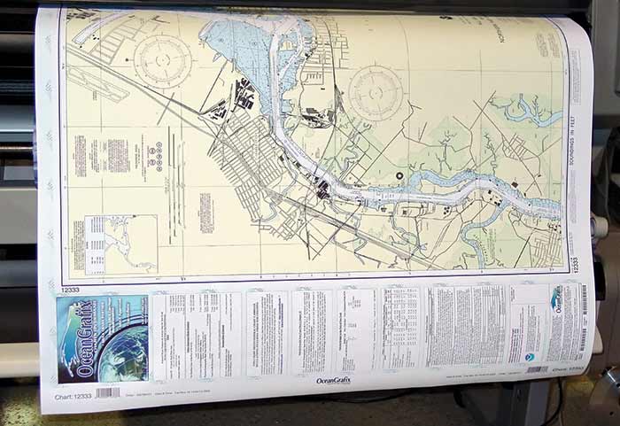
美國國家海洋和大氣管理局 (NOAA) 一直在維護 1000張紙質海圖 多年。光柵海圖是海圖的像素化圖片,可由 NOAA 批准打印 按需打印 (POD) 圖表代理.這些柵格圖表,其中包括 小冊子圖表 許多休閒划船者所依賴的,將在 2025 年 1 月被淘汰。
NOAA 也會在周圍生成 1200 個電子海圖 (ENC) 以各種規模幫助計劃巡航或定位錨地。 ENC 海圖是矢量圖,這意味著它們由數字數據組成,可以保存更多信息並且可以更快地縮放。當您放大電子矢量圖時,您可以在查看特定位置時看到更多細節——光柵圖無法做到這一點。 ENC 將被轉換為統一的矩形網格樣式,從而使 數字海圖到 9000 左右,根據 NOAA。許多較舊的圖表現在將具有更大的比例,為海員提供更多信息。用戶可以使用在線原型 NOAA 自定義海圖應用程序 (NCC) 使用幾年前開始的最新 NOAA ENC 數據創建自己的圖表。隨著紙質圖表即將結束,該系統正在改進。 ENC 最顯著的好處之一是它們在創建時是最新的。當您購買過去幾週前的紙質海圖時,您必須使用最新的本地水手通知手動更新它們,這可能需要很長時間,具體取決於海圖的年齡。
如果您喜歡為您的導航獲取新的傳統紙質圖表,那麼您很快就會不走運。但是,您將能夠利用 NOAA 的 NCC 以典型圖表的一小部分成本打印您自己的緊湊圖表,並有機會更改區域和細節以滿足您的需求。如果您不想打印自己的 ENC 海圖,可以從供應商處購買。現在,增強您的海圖儀比以往任何時候都更容易且更便宜。
——
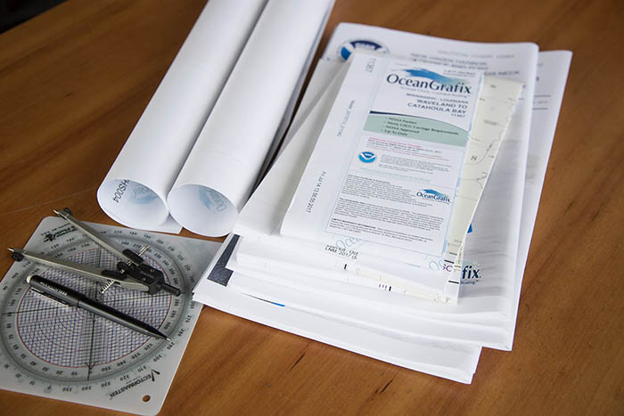
OceanGrafix,第一家提供按需打印海圖的公司,發布了 新的白皮書 題為“按需打印紙質海圖:為什麼認真的水手繼續攜帶紙質海圖來補充數字導航工具“。該論文闡述了在船上擁有準確紙質海圖的重要性,以及為什麼休閒划船者應結合當今的導航技術使用紙質海圖。
——
更新: 在 NOAA海岸調查 宣布向公眾發布 NOAA 自定義海圖 1.0 版 (來源:美國國家海洋和大氣局—— 在此處查找 NOAA 的新聞和更新)
2021 年 4 月 1 日,美國國家海洋和大氣局海岸調查辦公室發布 NOAA 自定義海圖 1.0 版, 一個動態地圖工具,使用戶能夠創建自己的 紙質和 PDF 海圖 源於 NOAA 官方電子海圖(NOAA ENC®),NOAA 首屈一指的海圖產品。
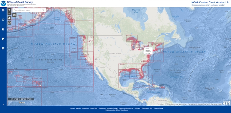
在線工具使用官方 NOAA ENC 數據以創建具有自定義比例和範圍的海圖,然後可以 下載為 PDF 文件.這些圖表具有傳統的圖表組件,例如紙質圖表符號系統 - 包括用於導航和導航危險的 NOAA 樣式符號,以及數據圖表的質量。雖然這些 可打印的 PDF 看起來有點不同 傳統紙質圖表, 和(最初) 將不符合受管制船隻的運輸要求, NOAA 自定義海圖利用最佳可用數據,為用戶提供改進的服務,並 確保 ENC 和 NOAA 自定義海圖 PDF 之間的一致性, 導致 最佳質量圖表 無論最終格式如何。
閱讀 NOAA 公告在這裡 並在 NOAA 官方網站
傳統紙質海圖的終結 (國際水文評論文章)


